|
Sources of the Bow—The
Little Fork Pass—Magnificence of the Scenery—Mount Murchison—Camp on the
Divide—A High Mountain Ascent—Future of the Bow Lakes—Return down the
Bow—Search fora Pass—Remarkable Agility of Pack-Horses—The “ Bay" and
the “Pinto " —Mountain Solitudes—Mount Hector—Difficult Nature of
Johnston Creek—A Blinding Snow-Storm—Forty-Mile Creek—Mount Edith Pass.
A FINE trout stream
entered the lake near our camp. This was, in fact, the Bow River. It
held a meandering course a short distance before entering the lake,
through a level meadow, or rather an open region, thickly grown over
with alder bushes and other shrubby plants.
We were delayed at this
camp by a period of unsettled weather with occasional storms and strong
winds, so that three days were required to finish our explorations. At
length, on the 24th of August, we broke camp, and followed the Bow
valley northwards towards the source of the river. The valley preserves
its wide character to the head of the pass, and is unusual among all the
mountain passes for several reasons. The ascent to the summit is very
gradual and constant, the valley is wide, and the country is quite open.
In about two hours we came to the summit, and, after a long level reach,
the slope insensibly changed and the direction of drainage was reversed.
This was a most
delightful region. The smooth valley bottom sloped gradually upward
toward the mountains on the east and west, and insensibly downward
toward the valleys north and south, thus making an extensive region with
gentle slopes curving in two directions, which in some way impresses the
mind with a sense of quiet grandeur and indefinite liberty. But chiefly
this region of the divide is made charming by a most beautiful
arrangement of the trees. There are no forests here, nor do the trees
grow much in groves or clumps, but each tree stands apart, at a long
interval from every other, so that the branches spread out symmetrically
in every direction and give perfect forms and beautiful outlines.
Between are smooth meadows, quite free of brush, but crowded with
flowering plants, herbs, and grasses, so that the general impression is
that of a gentlemans park, under the control and care of a landscape
gardener, rather than of the undirected efforts of nature.
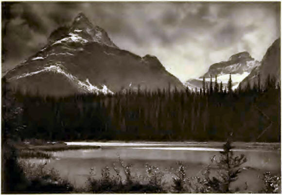
I shall never forget
the first view we had into the valley of the Saskatchewan. Approaching a
low ridge at the south side of the valley, suddenly there is revealed a
magnificent panorama of glaciers, lakes, and mountains, unparalleled
among the Canadian Rockies for its combination of grandeur and extent.
To the south,-one beholds the end of an immense glacier, at the
termination of which there are two great arched caverns in the ice. From
out these issue two roaring glacial streams, the source of the
Saskatchewan River, or at least of its longest tributary called the
Little Fork. Lofty mountains hem in this glacier on either side, only
revealing a portion of the vast neve which may be seen extending
southward for six or seven miles.
To the north and, as it
were, at our feet, though in reality a thousand feet below, lay a large
and beautiful lake with irregular outlines. This lake reaches several
miles down the valley of the Little Fork, which here extends northward
so straight and regular, that the view is only limited at the distance
of thirty miles by the long range of mountains on its east side. Dr.
Hector, who came through this region in the fall of 1858, comments on
the magnificent extent and grandeur of this view.
Through a notch in a
mass of mountains to the north, there appeared the extreme summit of
Mount Murchison, a very sharp and angular rock peak, which the Indians
regard as the highest mountain of the Canadian Rockies. According to
some rough angles taken by Dr. Hector, this mountain has an altitude of
13,500 feet. In Palliser’s Papers a sketch of- this mountain, as seen
from the summit of the Pipestone Pass, makes the rock peak much more
sharp and striking in. appearance even than that of Mount Assiniboine,
or of Mount Sir Donald in the Selkirks.
We continued our
journey over the pass and descended into the valley of the Little Fork
for several miles. The trail was very good, though the descent was
remarkably steep. We camped by a small narrow lake, in reality merely an
expansion of the Little Fork. Behind us was an area of burnt timber, but
southward the forests were in their primeval vigor and the mountains
rose to impressive heights above. The weather became rather dubious, and
during the night there was a fall of rain, followed by colder weather,
so that our tent became frozen stiff by morning.
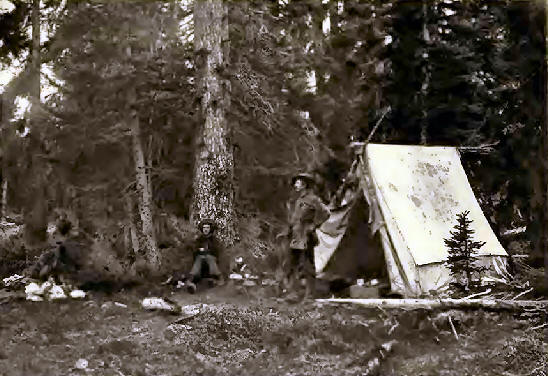
It seemed best to
return the next day to the summit of the pass, where everything
conspired to make an ideal camping place. Accordingly, the men packed
the horses and we located our camp on the crest of the divide, 6350 feet
above sea-level. The tent was pitched in a clump of large trees
surrounded on all sides by open meadows, where one could wander for long
distances without encountering rough ground or underbrush. Near the camp
a small stream, and several pools of clear water, were all easily
accessible.
The next day I induced
Peyto to ascend a mountain with me. He was not used to mountain
climbing, and had never been any higher than the ridge that we were
compelled to cross when we were walking around Mount Assiniboine, which
was less than 9000 feet in altitude. The peak which I had now in view
lay just to the northeast from our camp on the pass. It appeared to be
between 9000 and 10,000 feet high, and offered no apparent difficulties,
on the lower part at least. We left camp at 8:30 a.m. and passed through
some groves of spruce and balsam, where we had the good fortune to see
several grouse roosting among the branches of the trees. Peyto soon
brought them down with his six-shooter, in handling which he always
displays remarkable accuracy and skill. Many a time, when on the trail,
I have seen him suddenly take his six-shooter and fire into a tall tree,
whereupon a grouse would come tumbling down, with his neck severed, or
his head knocked off by the bullet.
A hawk scented our game
and came soaring above us so that we had to hide our birds under a
covering of stones, as of course we did not care to take them with us up
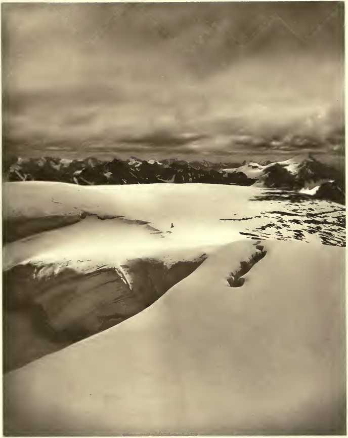
the mountain. We found not the slightest difficulty in the ascent till
we came near the summit. The atmosphere was remarkably clear, and some
clouds high above the mountains rendered the conditions very good for
photography. At an altitude of 9800 feet we came to the summit of the
artte which we were climbing, and saw the highest point of the mountain
about one-third of a mile distant, and considerably higher. Fortunately,
a crest of snow connected the two peaks, and with my ice-axe I knocked
away the sharp edge, and made a path. In a few minutes we were across
the difficult part and found an easy slope rising gradually to the
summit. We reached it at 11130, and found the altitude 10,125 feet. The
view from the great snow dome of this unnamed mountain was truly
magnificent. The Waputehk Range could be seen through an extent of more
than seventy-five miles, while some of the most distant peaks of the
Selkirks must have been more than one hundred miles from where we stood.
To the east about ten miles was the high peak of Mount Hector, almost
touching the clouds.
In the northern part of
the Waputehk Range we saw some very high peaks, though the clouds
covered everything above 11,000 feet. There seemed to be a storm in that
direction, as snow could be discerned falling on the mountains about
thirty miles distant. The general uniformity of height, and the absence
of unusually high peaks, a characteristic feature of the Canadian
Rockies, were very clearly revealed from this mountain.
Peyto was overwhelmed
with the magnificent panorama, and said that he now appreciated, as
never before, the mania which impels men to climb mountains. The storm
which we saw in the west and north passed over us toward evening, in the
form of gentle showers. On the next day, however, the weather was
perfectly clear and calm.
On the 26th of August
our horses were packed and our little procession was in motion early in
the morning, and we were wending our way down the Bow River. I cannot
take leave of this region, however, even in imagination, without a word
in regard to the unusual attractiveness of this part of the mountains.
In the first place
there are magnificent mountains and glaciers to interest the
mountaineer, and beautiful water scenes, with endless combinations of
natural scenery for the artist; moreover, the streams abound in brook
trout* and the lakes are full of large lake trout, so numerous as to
afford endless sport for fishermen. The botanist, the geologist, and the
general lover of science will likewise find extensive fields of inquiry
open to him on every side.
The time of travelling
required by us to reach the Upper Bow Lake was about nine hours, and
this was with heavily laden pack-horses. Hitherto, only those con-nected
with the early explorations, or the railroad surveys, have visited this
lake, but I cannot look forward to the future without conjuring up a
vision of a far different condition of things. In a few years, if I
mistake not, a comfortable building, erected in a tasteful and artistic
manner, will stand near the shores of this lake on some beautiful site.
A steam launch and row-boats or canoes will convey tourists and
fishermen over the broad waters of the lake, and a fine coach road will
connect this place with Laggan, so that passengers may leave Banff in
the morning and, after a ride of two hours by railroad, they will be
transferred to a coach and reach the Upper Bow Lake in time for lunch !
If a good road were constructed this would not be impossible, as the
distance from Laggan is only about twenty miles, and the total ascent
iooo feet.
With such visions of
the future and the more vivid memory of recent experiences in mind, we
took leave of the beautiful sheet of water, and continued on our way
down the Bow valley. It was not our purpose, however, to return to
Laggan directly, for Wilson had planned an elaborate route, by which
some of the wilder parts of the mountains might be visited. This route
would lead us over a course of about eighty or one hundred miles through
the Slate Mountains and Sawback Range, and eventually bring us to Banff.
We were to follow a
certain stream that enters the Bow from the north, but as we were now,
and had been for many days, outside the region covered by Dawson’s map,
it was impossible to feel certain which stream we should take. On our
way up the Bow River, Peyto had made exploring excursions into several
tributary valleys, but in every case these had proved to be hemmed in by
precipitous mountain walls, and guarded at the ends by impassable cliffs
or large glaciers.
The second day after
leaving the lake we came to a large stream which had not been examined
hitherto. Though we were far from certain that this was the stream that
had been indicated by Wilson, it seemed best to follow up the valley and
see where we should come out. After ascending an exceedingly steep bank,
we found easy travelling in a fairly open valley. One fact made us
apprehensive that there was no pass out of the valley. There was no sign
of a trail on either side of the stream, and none of the trees were
blazed. Indian trails exist in almost every valley where an available
pass leads over the summit, and where there are no trails the
probability is that the valley is blind, or, in other words, leads into
an impassable mountain wall. The valley curved around in such a manner
that we could not tell what our prospects were, but at about two o’clock
we reached a place far above timber line,—a region of open moors,
absolutely treeless,—surrounded by bare mountains on every side.
Our tent was pitched in
a ravine near a small stream. Immediately after lunch, Peyto and I
ascended 1000 feet on a mountain north of the valley with the purpose of
discovering a pass. From this point we saw Mount Hector due south, and
the remarkable mountain named Mount Molar, nearly due east. Three
possible outlets from the valley appeared from our high elevation. Peyto
set off alone to explore a pass toward the north, in the direction of
the Pipestone Pass, while I made an examination of a notch toward the
east. Each proved impossible for horses, if not for human beings. The
third notch lay in the direction of Mount Hector, and together we set
out to examine it. A walk of about two miles across the rolling uplands
of this high region brought us to the pass. It was very steep, but an
old Indian trail proved that the pass was available for horses. The
trail appeared more like those made by the mountain goats than by human
beings, for it led up to a very rough and forbidding cliff, where loose
stones and long disuse had nearly obliterated the path. We spent some
time putting the trail in repair, by rolling down tons of loose stones,
and making everything as secure as possible.
The next morning was
threatening, and gray, watery clouds hung only a little above the summit
of the lofty pass, which was nearly 8000 feet above sea-level. I started
about an hour before the outfit, as I desired to observe the horses
climbing the trail. I felt considerable anxiety as they approached. All
my photographic plates, the result of many excursions and mountain
ascents in a region where the camera had never before been used, were
placed on one of the horses, for which purpose one of the most
sure-footed animals had been selected. In case of a false step and a
roll down the mountain side, the results of all this labor would be
lost. The horses, however, all reached the summit in safety.
These mountain
pack-horses reveal a wonderful agility and sagacity in such difficulties
as this place presented. In fact, the several animals in my pack-train
had become old friends, for they had been with me all summer. Peyto, as
packer, always rode in the saddle, for the dignity of this office never
allows a packer to walk, and besides, from their physical elevation on a
horse’s back they can better discern the trail. A venerable Indian
steed, long-legged and lean, but most useful in fording deep streams,
was Peytos saddle-horse. The bell-mare followed next, led by a
head-rope. The other horses followed in single file, and never allowed
the sound of the bell to get out of hearing. There were two horses in
the train that were endowed with an unusual amount of equine
intelligence and sagacity. The larger of the two was known as the “Bay,”
and the other was called “Pinto,” the latter being a name given to all
horses having irregu1ar white markings. These animals were well
proportioned, with thick necks and broad chests, and, though of Indian
stock, they probably had some infusion of Intelligence of Pack Horses.
Spanish blood in their veins, derived from the conquest of Mexico.
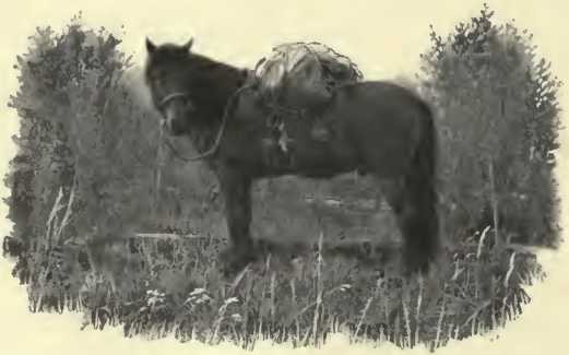
The Pinto was
remarkably quick in selecting the best routes among fallen timber, or in
avoiding hidden dangers, but the Bay was far more affectionate and fond
of human company. In camp, all the horses would frequently leave the
pasture and visit the tent, where they would stand near the fire to get
the benefit of the smoke when the flies were thick, or nose about in the
hope of getting some salt. On the trail, it was always very interesting
to watch the Bay and Pinto. They would unravel a pathway through burnt
timber in a better manner than their human leaders, and would calculate
in every case whether it were better to jump over a log or to walk
around it. But one day I was surprised to see the Bay jump over a log
which measured 3 feet 10 inches above the ground. With a heavy, rigid
pack this is more of a feat than to clear a much greater height with a
rider in the saddle. Sometimes when the trail was lost we would put the
Pinto ahead to lead us, and on several occasions he found the trail for
us.
The summit of the pass
revealed to us one of those lonely places among the high mountains where
silence appears to reign supreme. We were in an upland vale, where the
ground was smooth and rolling, and carpeted with a short growth of grass
and herbs. On either side were bare cliffs of limestone, unrelieved by
vegetation or perpetual snow. Here no birds or insects broke the silence
of the mountain solitude, no avalanche thundered among the mountains,
and even the air was calm and made no sound in the scanty herbage. All
was silent as the desert, or as the ocean in a perfect calm. The dull
tramp of our horses, and the tinkling of the bell, were the only sounds
that interrupted the death-like quiet of the place. It is said that such
places soon drive the lost traveller to insanity, but in company with
others these lonely passes afford a delightful contrast to the life and
motion and sound of lower altitudes.
As we advanced and
commenced to descend, the north side of Mount Hector began to appear. It
was completely covered with a great ice sheet and snow fields. Mount
Hector is a little more than 11,000 feet in altitude, and gives a good
example of how the exposure to the sun affects the size of glaciers in
these mountains. On the south and west sides of Mount Hector there is
almost no snow, while the opposite slopes are flooded by a broad glacier
many miles in area, and brilliant in a covering of perpetual snow.
At the tree line a
trail appeared, and led us in rapid * descent to the valley. The scenery
on all sides was magnificent. Many waterfalls came dashing down from the
melting glaciers of Mount Hector and joined a torrent in the valley
bottom. The great cliffs about us, and the lofty mountains, visible here
and there through avenues in the giant forest trees, were illumined by a
brilliant sun, ever now and again breaking through the clouds. About
eleven o’clock we stopped to have a light lunch, as was our custom on
all long marches. Peyto loosed the girdle of the horses, slipped off the
packs, and turned the animals into a meadow near by. Meanwhile our cook
cut firewood and made a large pot of tea, which always proved the most
acceptable drink when a long march had made us somewhat weary. These
brief rests of about forty minutes in the midst of a day’s march always
proved very beneficial to men and horses.
A long straight valley
led us southwards for many miles. In every clear pool or stream, trout
could be seen darting about and seeking hiding-places, though we had no
time to stop and catch them. At about one o’clock we reached the
Pipestone Creek and obtained a view of Mount Temple and other familiar
peaks about fifteen miles to the south.
We camped near the
stream in a meadow, not far from the Little Pipestone Creek. As the
march of this day had brought us back to the region covered by the map,
we had little apprehension of losing our way in the future.
The next day we
followed up the Little Pipestone . Creek and enjoyed a fine trail
through a dense forest. We camped near the summit of a pass south of
Mount Macoun, which I partially ascended after lunch. The rugged peak
named Mount Douglas lay due east, and presented some very large and fine
glaciers.
Our camp was on a
little peninsula jutting out into a lake, with water of a most brilliant
blue color. The sunset colors this evening were heightened by the
presence of a little smoke in the atmosphere, which gave a deep copper
color to the western sky, while the placid lake appeared vividly blue in
the evening light.
The following day,
which was the first of September, we continued south over a divide and
into the valley of Baker Creek, which we followed for several hours, and
then took a branch stream which comes in from the east, and finally
camped in a high valley. We were now in the Sawback Range, where the
mountains are peculiarly rugged, and the strata thrown up at high
angles. The weather was giving evidence of an approaching storm, and
before we had made camp the next day in Johnston’s Creek, rain began to
fall.
Hitherto the nature of
the country since leaving the Upper Bow Lake had been such as to render
the travelling very easy and delightful, but from this point on, we met
with all sorts of difficulties. In the lower part of Johnston’s Creek,
and in the valley of a tributary which comes in from the northeast, the
trail was covered by fallen timber, and our progress was very slow and
tedious. Moreover, the weather now became very bad, and we were caught
near the summit of a pass between Baker Creek and Forty-Mile Creek in a
heavy snow-storm, so that the trail was soon obliterated and the
surrounding mountains could not be seen. Fearing that we might lose our
bearings altogether, Peyto urged forward the horses at a gallop, so that
we might get over the pass before the snow gained much depth.
The descent into the
valley of Forty-Mile Creek was very steep, and we camped among some
large trees with several inches of snow on the ground. The next day we
urged our horses on again and followed down the valley of Forty-Mile
Creek. In some parts of the valley we found absolutely the worst
travelling I have anywhere met with in the Rockies. The horses were
compelled to make long detours among the dead timber, and the axe was
frequently required to cut out a passage-way. Frequent snow showers
swept through the valley, and, though very beautiful to look at, they
kept the underbrush covered with damp snow and saturated our clothes
with water.
In the afternoon we
reached the summit of the Mount Edith Pass, and once more caught- sight
of the Bow valley and the flat meadows near Banff. A fine wide trail or
bridle-path, smooth and hard, led us down toward the valley. The
contrast to our recent trails was very striking. We walked between a
broad avenue of trees, each one blazed to such an extent that all the
bark had been removed on one side of the tree, and some were practically
girdled. This was very different from our recent experience where we had
only found a small insignificant axe-mark on some dead tree, about once
in every quarter mile, or often none at all during hours of progress.
On the fifth of
September we reached Banff late in the evening, and found that the
valley was free of new snow by reason of its lower altitude. We had been
out for twenty-three days and had covered, in all, about one hundred and
seventy-five miles. |


