|
Canadian Pacific Railway
Company.
TRANSPORTATION has been
a serious problem in Canada from the beginning, as was necessarily the
case in a country of such enormous area. In early times, when France was
in possession, the immigrant followed the rivers. First of all, however,
he crossed the Atlantic in vessels of 200 to 400 tons, the voyage
lasting two or three months, with scurvy or typhus usually raging on
board. On entering the St. Lawrence the ships anchored at nightfall; the
charts of the river were imperfect, and there were no lights, except
here and there a kettle of blazing pine-knots hung on a tree outside a
King’s post. If he did not join the fur-traders, the new settler began
clearing the forest in some seigniory, for a feudal land tenure, based
on the Custom of Paris, existed down to 1854. As may be seen to this
day, the French Canadian farms were very narrow and very long, this mode
of subdivision giving every holder a frontage on the river, bringing the
people closer together, brightening their social life and affording them
better protection against the Iroquois. The St. Lawrence and its
affluents were the channels of such primitive trade as was carried on in
the interior. Commercial intercourse with the British and Dutch Colonies
to the south was prohibited, although many a package of beaver was
conveyed down Lake Champlain or the Kennebec and bartered for English
goods. Vessels built at Quebec with the aid of bounties, carried lumber
and flour to the French West Indies and Acadia, but the chief export
trade, that in peltries, was done with Franco.
In those times the
maritime nations of Europe were seeking a short route to Asia. Jacques
Cartier, Champlain. and many others supposed from what the Indians told
them that, if they sailed up the St. Lawrence to the middle of the
Continent, they would meet waters flowing the other way, down which they
could sail into the Oriental seas. So sure were they that this would
turn out to be the true North-West passage, that when some of them got
to Laehine, a few miles west of Montreal, they fancied they were on the
high road to China and accordingly gave it that name. Two centuries
later it has become possible to reach China via Canada, not, however, by
the St. Lawrence, but by rail as tar as Vancouver. Although France has
lost her North American Empire, the names of her missionaries and
explorers will live forever in the history of the Continent. They
discovered the Mississippi, Lake Superior and the Red River of the
North; established posts where Chicago, Detroit and other Western
American cities now stand, for, as one of them said, they had a
remarkable instinct for good situations, and did much then, and later,
for the Canadian North-West. We owe not a little to those intrepid men,
who sallied forth into the wilderness with 110 selfish motives, but with
the object of extending the King’s dominions and promoting the glory of
God.
When the colonisation
of Upper Canada commenced under British rule, the immigrant in his
Western journey still followed the water routes, for there were as yet
no roads. The canoe or Durham boat containing his worldly effects had to
be dragged by oxen through forty miles of rapids between Montreal and
Kingston, or, where that was impossible, portages had to be made through
the forest. The cost of procuring fresh supplies and of shipping produce
to market was enormously enhanced by the difficulties of moving them up
and down rivers in their natural condition. It soot: became apparent
that, if the country was to make any substantial progress, it would be
necessary to build canals at various points on the St. Lawrence and its
principal tributaries. The local advisers of the Imperial Government
favoured the project, and, though they may have attached more importance
to its military than to its commercial aspect, Canadians are greatly
indebted to them for the impulse they gave and the substantial aid they
furnished to the movement. Between 1820 and 1850 the main rivers were
tolerably well equipped with canals, locks and dams, most of which have
since been enlarged, to meet the growth of traffic. The Lachine Canal
was the first to be built, but the most important was the Welland. Many
of the United Empire Loyalists who came to Canada at the close of the
American Revolution, entered by way of Niagara, and gradually pushed
their settlements into the Western Peninsula of the Province. Their
surplus supplies could not be conveyed to Montreal within a shorter
period than six weeks to two months. (It may be interesting to recall
that the ocean rate on general merchandise from Liverpool to Montreal
was £1. 2. per ton. while for the next 400 miles westward, by the St.
Lawrence, it was £6. 12. 9.) The Peninsula was extremely fertile, and
whole colonies of settlers were flocking in from the United Kingdom. But
unless a canal were cut through Canadian soil from Lake Erie to Lake
Ontario, a distance of 27 miles, to overcome the obstacle to navigation
presented by the Falls of Niagara, it was clear that its trade with
England would be diverted from the St. Lawrence route to the Erie Canal
and the Port of New. York, a state of affars which might entail serious
political consequences. The construction of the Welland canal saved the
situation, and it soon became a formidable competitor to the Erie canal
for the traffic of the Western States.
Such in a few words,
was the origin of the Canadian canal system. The canals on the St.
Lawrence from Montreal to Lake Erie are, all told, 70 miles in length.
Those on the Ottawa, Rideau and Richelieu rivers and Lake Champlain are
not so long. It is not easy to ascertain the first cost of these canals,
but the total expenditure on their construction, reconstruction and
upkeep, together with that on inland harbours, has exceeded
$100,000,000. Tolls were abolished some years ago. In the United Kingdom
the canals were built by private capital, and some have passed under the
control of the railways. The construction of the Welland canal was
undertaken by private capital, but, fortunately for us and fortunately
too for the shareholders, the company had to abandon the project. All
our canals without exception are now owned and operated by the Dominion
Government For seven months of the year they render good service in
keeping down rail rates, besides transporting a considerable tonnage of
the bulkier kinds of freight. The “all-water route” from the head of
Lake Superior by the Welland canal to Montreal usually determines the
rate on wheat from the Canadian West to the seaboard, just as the Erie
canal does for grain from Buffalo to New York.
The ‘‘all-water route"
via the St. Lawrence has not, however, altogether fulfilled its earlier
expectations. It obtained a large share of the traffic of the Western
States thirty or forty years ago when the wheat-belt of the continent
lay round Lake Erie and Lake Michigan, and the grain was carried East by
small sailing vessels, which traversed the Welland and lower canals at
their leisure and had nothing to fear from the railways of the day. Such
conditions no longer prevail. The wheat-belt has extended to the
Canadian North-West, Minnesota and the Dakotas, and the present output
there and elsewhere, in the West is far in excess of the output of
former times. There are now 40,000,000 people in the States bordering on
or served by the Great Lakes. An immense traffic has arisen between Lake
Superior and Lake Erie, the former sending down wheat, iron ore, lumber,
and other commodities, and taking back coal and general merchandise.
Before the recent depression, over 50,000,000 tons of freight , valued
at $550,000,000, passed through the locks at the Soo in a single season,
that of 190f). The Welland and St. Lawrence canals have a depth of 14
feet, whereas between Lake Erie and Lake Superior there is a 20 or
21-foot channel, which has en abled the United States companies to
create a vast fleet of steam vessels, most of which are beyond the
capacity of the Welland. Although Canadian vessels are excluded from the
inland or coasting trade of the United States, our own fleet on the
Upper Lakes is growing rapidly; but many of our vessels are also too
large for this canal. Some carry wheat to the Lake Erie end of it and
“lighter,’ ’since boats carrying more than 75,000 bushels cannot get
through without “lightering,” whilst the larger vessels sail to Georgian
Bay ports, transfer their cargo to the elevators, and steam back to Fort
William or Port Arthur. The grain is transported from the elevators by
Canadian railways to the ocean steamers at Montreal. In like manner,
United States steam vessels, of which many are of the tonnage of a
modern ocean steamer, run from Duluth and Chicago to Buffalo, and turn
over their grain, not to the Erie canal any longer, but to the railways,
which haul it to New York, Boston, or Baltimore. Finally, a great deal
of grain, from Canada and the United States, is now carried to the
seaboard from the place of production in the West by “all-rail.” This
has been rendered possible by the improvement of road-beds and the
employment of more powerful locomotives and more capacious cars. When
business on the Upper Lakes is slack, as was the case recently, Canadian
vessel owners on our “all water route,” reduce the rates to Montreal to
so low a figure that a deluge of United States export grain goes to that
port, with the result that protests are heard from New York. A natural
water-way such as that of the St. Lawrence can never become a negligible
factor in transportation. It is worth noting, also, that the Canadian “
water-and-rail” routes to Montreal are, or can be made, considerably
shorter than the United States “water-and-rail" route to New York. Our
Georgian Bay ports are much nearer Duluth and Chicago than Buffalo is,
while the rail journey from them to Montreal by a new branch of the
Canadian Pacific Railway will be 80 miles less than that from Buffalo to
New York
The State of New York
is enlarging the Erie canal to allow of its admitting 1,000-ton barges,
and various canal schemes of a more ambitious character are talked of in
the United States. The Canadian Government contemplates deepening the
Welland canal. This, however. would not be of much avail unless the
canals below Prescott were also deepened. Meanwhile the Georgian Bay
Canal project, estimated to cost $100,000,000, is receiving support in
various quarters, notably from the districts where the money would be
spent. Whatever the next few years may bring forth, the Cana; dian
people will make any reasonable sacrifice to ensure the transport of
Canadian traffic by Canadian routes. Manifestly it is their interest to
do so. The old Roman said that no estimate could be formed of the future
wealth of a district that possessed fifteen miles of olives and vines.
But what shall be said of the future of a region like the Canadian West,
which, with a present population of a million, has still 250,000,000
acres of black loam uncultivated? In another generation it will contain
more people than all the rest of Canada, and in time to come, probably
more than there are to-day in the Three Kingdoms. The possibilities of
the West are so great that one can hardly exaggerate the importance of
adopting a liberal policy, which shall retain the traffic all the way
from the wheat-field to Europe in Canadian and British channels.
No sooner had the early
canals been completed than it became necessary to undertake the
construction of railways in Upper and Lower Canada. The canals had
developed in some degree the basins of the rivers and lakes. The
introduction of the locomotive enabled settlers not only to enter Upper
and Lower Canada, but to pass into the vaster regions beyond. Our
neighbours in the United States began to build railways in 1830. and,
private capital being scarce, the Federal, State and Municipal
Governments, during the next forty years, voted liberal aid in money,
land and guarantees. Canada followed their example, and, in proportion
to population and resources, carried that form of paternalism to a
greater length. The Imperial Government gave initial assistance by
guaranteeing a loan of $7,500,000. Canada’s credit in England was not
good, for, after one or two local railways had been built, a rebellion
broke out over the question of Responsible Government. Moreover the
abandonment by England of the policy of Protection, which included the
preferential treatment of Colonial exports, dislocated our trade for a
time. One of the first railway surveys was that carried out by Captain
Yule of the Royal Engineers, who laid down a line between Quebec and St.
Andrew’s, in New Brunswick, through territory belonging at that time to
the British Crown. Unhappily, in 1842, the Ashburton Treaty —Lord
Palmerston styled it the Ashburton Capitulation-—deprived Canada of the
Aroostook District, brought the northern boundaryof the State of Maine
to within a few miles of the St. Lawrence, and, when the time came for
building the Intercolonial Railway, necessitated a circuitous route to
Halifax and St. John At first the Canadian Parliament was disposed to
establish Government ownership of railways, owing to the difficulty of
enlisting private capital; but British money was found for the
construction of the Grand Trunk, and Government ownership remained in
abeyance for a time.
The history of the
Grand Trunk Railway is well known in England and Canada. The original
prospectus, issued in 1853, promised a return of 11>2 per cent, per
annum on the share capital, besides the stated interest on the bonds.
Canada and Canadians were blamed for the misfortunes of the road, but
soma of these were unavoidable. There was in England and another in
Canada, but as the actual control was exercised from London, 3,000 miles
away, it is not surprising that there was a good deal of waste in
construction. The cost of bringing in materials for a pioneer road was
excessive in those days, and the Canadian Government did not grant as
much financial assistance to the enterprise as had been expected. Before
the line was completed the panic of 1857 occurred. Wheat, which during
the Crimean War of 1854-56 had realised $2.50 per bushel at Toronto,
dropped to half that figure, and there was a tremendous collapse in land
values. Immigration fell off and remained at a low ebb for a long time,
the Western and North-Western States, with their free prairie
homesteads, being more attractive, even to the native Canadian, than the
bush lands of Canada. The original line of the Grand Trunk was fairly
well constructed, but the small, wood-burning locomotives and light iron
rails were badly fitted for the Canadian winter. Subsequently the
Canadian Board became involved in politics. In 1862 the General Manager
stated in a letter to the Government that the cost of the original line
had been .£12,000,000 sterling, of which the Canadian Government had
subscribed over £3,000,000. He added, however, that the company had
afterwards been forced by political pressure to spend probably more than
£3,000,000 “ in constructing parts of the system, which, though of
benefit to Canada, are, commercially, entirely worthless and only drags
upon the paying portions of the railway.” Parliament blundered in fixing
upon a gauge of 5 feet 6 inches, when most of the United States roads
had a gauge of 4 feet 8^2 inches. As a consequence of this through
traffic had to be transferred from one car to another at the
international frontier. This was a painful chapter of railway history,
and, in consequence, Canadian credit suffered in England for years.
Portland in Maine was selected as the winter terminus, simply because
there was no access by rail to the Canadian ports of St. John and
Halifax, and, by the Ashburton Award the short all-British route to them
had been lost. It may be added that it was the Ashburton Award which,
years afterwards, obliged the Canadian Pacific to cut across Maine on
its journey to St. John rather than follow the longer route on British
soil; and it is owing to the Ashburton Award that the Grand Trunk
Pacific is unable to reduce the distance between Quebec and Moncton, as
traversed by the Intercolonial, by more than 30 miles. If, as a recent
English writer puts it, “both the Canadian Pacific and the Grand Trunk
proper desert the British flag shortly after leaving Montreal for the
Atlantic seaboard in winter,” it is only fair to indicate on whose
shoulders the responsibility really lies.
The east - and - west
direction of Canadian lines is imposed on them by the configuration of
the country, and, in some measure, it may be suspected, by the American
tariff, which taxes all Canadian products bound south save those going
in bond. The Grand Trunk was carried east and west that it might serve
the settled districts in the St. Lawrence Valley, and connect Chicago
and the Western States with Montreal and Portland. The Intercolonial
joins the cities on the St, Lawrence to. the ports of the Maritime
Provinces, and hence could not run otherwise than east and west, whilst
the Canadian Pacific was built as a national work expressly to connect
the newer Provinces in the West with the older ones in the East. At the
present time United States roads are running spurs from south to north
into the Canadian North-West and British Columbia for the purpose of
diverting traffic to United States ports, but so far they have not
accomplished much. In his famous report of 1S39, Lord Durham recommended
the establishment of the bonding privilege between Canada and the United
States, which' was brought about some years later. Railway traffic in
both countries is left free to follow the most economical route. Goods
for Canadian use reach Canada from Europe by New York or Boston; a
portion of the surplus grain and package freight of the Western States
is shipped to Europe by way of Montreal; the Canadian Pacific takes
products of the Pacific States to the Atlantic or to New England, and,
contrariwise, carries New England wares to the Pacific States; while
American railways handle shipments from Eastern to Western Canada. All
this intercommunication goes on without interference from the Customs
officers on either side of the boundary, who merely see that the bonded
cars are properly sealed. When this arrangement—excellent for both
countries— grew up about 1855, it was predicted that henceforth Canadian
roads would all run from north to south in. order to meet the American
roads at the boundary, but the prophecy was not fulfilled. At that time
there was reciprocity of trade with the United States to the extent of a
free interchange of natural products. The treaty was abrogated by
Congress in 1866, and Canada forthwith set about building up trade with
the United Kingdom through the use of Canadian railways and Canadian
ports, which involved the carrying of Canadian produce from west to east
and of British golds from east to west. The heavy American tariff on
Canadian productions has fired us with the ambition to be commercially
as well as politically independent of the United States, and has
contributed as much as any other single agency to our recent closer
union with Britain.
After the Grand Trunk
came the Intercolonial, which, viewed as an experiment in Government
ownership and operation, has been disappointing. True, the road is
handicapped by its roundabout route and by being exposed to water
competition at almost every point. Its rates in general are low, its
special rates on Nova Scotia iron and steel bound west being probably
less than cost of haul; while the bulk of its local traffic consists of
coal, lumber and other rough commodities in the transportation of which
there is little profit. The capital account now stands at 887,500,000,
and no interest has ever been paid upon it. The system is 1,450 miles
long. The Government has also 267 miles of road in Prince Edward Island,
making over 1,700 miles in all under its control. The Island line has
never paid operating expenses; its capital account is $8,000,000. On
both roads politics play a vicious part, and the Government, in despair,
is contemplating their lease to a company railway or the transfer of the
management to a commission.
After the Intercolonial,
the Canadian Pacific was constructed. The construction of a line from
the Atlantic to the Pacific Ocean had been the dream of enthusiasts for
years, but did not take bodily form till British Columbia and the
North-West were admitted into Confederation. The Federal Government
tried its hand at building the road, but in 1881 made a contract with
the present Company, which completed the work. Instead ,of dwelling on
the success of the Canadian Pacific Company, a word may be said on the
development of the West. Burke, in one of his speeches on the American
Colonies, spoke of their export of a few thousand quarters of
breadstuffs to England as the splendid act of “this child of your old
age, which, with a true filial piety, with a Roman charity, has put the
full breast of its youthful exuberance to the mouth of its exhausted
parent.” At that time the American Colonies had been settled for more
than a century. This year, with an average harvest, the Canadian West,
which really was not opened till the completion of the Canadian Pacific
24 years ago, will export, principally to England, not less than
15,000,000 quarters of wheat, to say nothing of other grains, and
probably 150,000 head of cattle. In 18S8 the City of Winnipeg received
and transmitted by rail 110,000 tons of goods. In 1908 the total
exceeded 2,500,000. This takes no account of the traffic in grain and
other articles passing through Winnipeg en route to other points east
and west, but relates solely to the trade and manufactures of Winnipeg
itself. In 1889 the traffic on the Central division of the Canadian
Pacific, which extends from Lake Superior to Swift Current, through the
larger portion of the wheat-belt, was less than 350,000 tons, whereas
last year it exceeded 10,000,000. Before the Canadian Pacific was built
it cost six shillings, in English money, to transport a bushel of wheat
from Winnipeg to Liverpool. Now it costs nine-pence, although the haul
by rail, the Great Lakes and the Atlantic, is 4,500 miles long. The
Canadian Pacific has over 5,000 miles of completed road in the West, and
the Canadian Northern, Great Northern, and Grand Trunk Pacific about
2,000 more. In the older districts no farmer is situated more than 12 or
15 miles from a railway. Man for man, the mileage is greater than in
Minnesota, Dakota, or any other portion of the United States; and rates
on wheat and other commodities are as low or lower than those to and
from corresponding American points.
This incomparable
region is receiving 150,000 immi grants a year even in these
comparatively dull times, the number from the United States, who came in
1908, exceeding 60,000. Since 1898, when the rush from the United States
began in earnest, neighbours in the South have invested $ 300,000,000 in
lands, stores, mines, cattle-ranches, lumbering and elevators in the
Provinces of Alberta and Saskatchewan. British Columbia is also becoming
populated, although it must be borne in mind that its area is enormous,
Its coal, gold-copper and silver-lead mines are prospering, its lumber
trade has grown to formidable proportions, and its fisheries are the
richest in Canada, the annual catch being now worth more than that of
Nova Scotia. Fruit-growing is becoming an important industry, and, when
Vancouver Island is properly settled, is likely to expand to great
dimensions. The Canadian Northern Railway has a large mileage west of
Lake Superior, and some day, no doubt, will reach both oceans. The Grand
Trunk Pacific will soon have to be added to the list of transcontinental
railroads. The Government is building the section, 1,800 miles long,
between Moncton in New Brunswick, and Winnipeg, and will lease it to the
Company, while the Company is constructing from Winnipeg westward to
Prince Rupert on the Pacific coast. It has been recently stated in
England that a controlling interest in the Canadian Pacific is held in
the United States. As a matter of fact such holdings of Canadian Pacific
securities are very small indeed, the bulk being owned in England,
Germany and Holland
The earliest statistics
of railway operations in Canada go back to 1875, and a few figures may
be given to show the progress made since that date, premising that the
mileage increased from 5,0U0 in 1876 to 21,000 in 1906. In 1908 it was
23,000:—
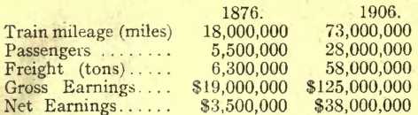
It will be agreed, that
is a very satisfactory advance in the space of 31) years. The progress
made by the railways from 1900 to 1906 was so remarkable as to lead one
of our public men to declare that if the Nineteenth Century belonged to
the United States, the Twentieth belongs to Canada. The aggregate
capital cost uf Canadian railways down to 1908, counting the subsidies
granted by the Federal, Provincial and Municipal authorities, and the
expenditure on Government railroads, has been $1,600,000,000 ; and, in
addition, land grants have been voted to the total amount of 50,000,000
acres. So far the railways, as a whole, have not yielded any large
return to the investor. The net earnings in 1908 were only sufficient to
pay a dividend of 3.20 per cent on the stock and bond issues of the
company roads. The lines built and operated by the Government yielded
nothing. A better condition of things may be looked for as population
increases and the extensive natural resources are turned to account
Synchronising with the
development of the railroads, it became necessary to deepen the St.
Lawrence between Quebec and Montreal. This work has occupied 60 years.
The depth of water at the shallowest part was, in the earlier days of
navigation, 11 feet Ocean vessels bound for Montreal had to be
“lightered” at Quebec, while those outward-bound from Montreal loaded
only a portion of' their cargo, the remainder being taken to Quebec in
tow-barges. A uniform depth of 30 feet has now been obtained throughout
the 170 miles of river, and the channel has b^en widened. The cost of
this undertaking has been about $10, U00,000,and the quantity of
material removed by the dredges amounts to 45,000,000 cubic yards. The
result is that Montreal, which is 1,000 miles from the open Atlantic,
250 from salt water and 80 above the nearest tidal influence, has been
transformed into a port capable of accommodating all but the very
largest ocean vessels. We are vain enough to think that this work is in
a measure comparable to the deepening of the Clyde from Greenock to
Glasgow. The Allan Company began carrying the mails between England and
Canada in 185G, and in the intervening half-century has rendered
splendid service The Imperial Government has paid a postal subsidy to
the Cunard Line almost uninterruptedly since 1840, but has paid nothing
to the Allans or to any other Canadian steamship line operating on the
Atlantic, beyond the mere sea postage collected on mail matter 'going
from England to Canada. Long ago the Canadian Government felt some
jealousy that Britain should help the Cunard Line whoss vessels sail to
New York, rather than the Allans, who were doing so much for the St.
Lawrence trade. This seeming neglect may, however, have been a blessing
in disguise. At any rate, thrown upon our own resources, we have
succeeded in dissipating the bad name of the St. Lawrence route among
navigators and insurance men, and in making Montreal one of the chief
ports of North America. Its ocean-going tonnage, in and out, in 1908 was
4,000,000 ton. The Canadian Pacific “Empresses” and the Allan turbine
steamers, which now carry the mails, are among the finest vessels
afloat. The contrast between them and the tiny, high-pooped barks of
Jacques Cartier’s day sums up the progress of ship-building in the last
300 years. Ocean freight rates from Montreal are as low as those from
New York and Boston. Steamers conveying perishable articles are
furnished with an admirable system of cold storage, which is under
Government supervision, while the moderate temperature of the northern
route, in summer, attracts shipments of meats from United States. The
ocean traffic from St. John is growing rapidly, and Quebec, though for
the present eclipsed by Montreal, will some day become the great port of
the St. Lawrence, Since 1867, when Confederation took place, the total
tonnage of sea-going shipping entered and cleared at Canadian ports,,
has risen from 4,000,000 to 17,000,000 tons register.
The Imperialist who
wishes to traverse the Empire can now travel continuosly under the
British flag. The Canadian Pacific and Allan steamships will convey him
from England to Halifax, St. John, Quebec or Montreal, whence he may
journey across the continent by a Canadian Pacific express train to
Vancouver. Here he finds “All-Red” steamers sailing to Japan and Hong
Kong, whence he may proceed in other “All-Red” vessels to India or South
Africa, or may travel back to England through the Suez Canal.
In conclusion, it is
manifest that Canada has made up her mind to be true to herself and yet
to remain affectionately attached to Britain. An American poet tells of
the little flower which guided the hunter on the plains:—
“See how its leaves all
point to the north, as true as the magnet—
“It is the compass
flower, that the finger of God has suspended "Here on its fragile stalk,
to direct the traveller’s journey
“Over the sea-like,
pathless, limitless waste ot the desert.”
And an English writer,
commenting on these lines, has expressed himself in terms with which, I
am sure, the great majority of the people of Canada agree:—-“So it must
be with all Canadians. Their hearts, differ as men may on political or
social or religious questions, are true to their North-Land—a land of
great rivers and inland seas, of illimitable prairies and lofty
mountains, of rich sea-pastures and luxuriant wheatfields—a land of free
government and free speech—a goodly heritage with which they can never
part to & foreign Power.” |


