|
In attempting to give a
narration of such incidents regarding the pioneers of the county of Bruce
as the author has succeeded in gathering, the reader is asked to bear in
mind the fact that they who have a right to be so entitled should properly
be referred to under several widely divergent classes. Of these the first
were the early fur traders, to be followed by explorers, Indian
missionaries and the hardy fishermen, who were profitably engaged in their
calling at the Pishing Islands years before a surveyor had even entered
this part of the province. The work of these venturesome men was largely
past when the pioneers who formed the vanguard of progress and
civilization entered the "Queen's Bush," and made the first permanent
settlements in the county. This latter class of pioneers were the men who
cleared the forest, opened up roads, established schools, formed the
various municipalities within the county and started the wheels of its
many industries; men characterized by an enthusiasm, fortitude and
industry that made them the peers of any that ever made a clearing and a
settlement in a Canadian forest.
Ruins of what evidently
were forts erected by fur traders are to be seen at Cape Croker, Stokes
Bay, Bed Bay and Southampton. Many are the surmises about these ruined
forts. Of what nationality were they who erected them, and when and why
abandoned? To these and kindred questions no certain reply can be given.
Some assert that they were Hudson Bay Company forts, but satisfactory
proof that such was the case has not been met with by the writer. Canada
was not ceded by the French to Great Britain until 1763. Before that date
it is incredible to think that the Hudson Bay Company's factors were
venturesome enough to erect trading posts on French territory. If erected
since that date, surely these forts would have been known and referred to
in the records of the War of 1812, when vessels of both the English and
American navies sailed on Lake Huron. These and other reasons, such as the
finding of small relics of apparently French origin near the sites of
these ruins, lead to the supposition that the forts were erected by French
traders. Lacking positive evidence, any view, however, is only conjecture.
The following facts about the early fur
traders at Saugeen were given by Joseph Longesen., to Joseph Normandin,
an old voyageur, who as a boy lived at Goderich at the time of its
settlement, but who removed to Penetanguishene in 1837, and then to
Killarney. Normandin's age is uncertain, except that he was born prior to
1820. He related these incidents to Fred Lamorandiere, the Indian
interpreter at Cape Croker, to whom the author is indebted for them, and
which are here given in a form but slightly changed from the recital as
received: "One Pierre
Piché, in the year 1818, came from Lower Canada to Mackinaw to take part
in the adventures and profits of the fur trade. He engaged with one Dr.
Mitchell, of the military post of Michilimackinaw, as it was then called.
(The Indian name of that island was "Mishi Mikinac," meaning a "great
turtle.") Having heard of the richness of the Saugeen country in furs he
went there to establish a trading post. It was on the flat, on the south
side of the Saugeen River, that he built for himself a house and store,
and completed the establishment by taking to himself a wife from the tribe
of Indians residing in that vicinity. He received his supply of goods for
trading through Dr. Mitchell, and afterwards from his sons George and
Andrew. The Mitchells resided first at Mackinaw, but when that was ceded
to the United States, they moved to Drummond Island, and when that, too,
became American territory, to Penetanguishene. Piché was a man of great
strength and bravery, and on account of these qualities he succeeded in
obtaining and keeping control of the best part of the fur trade in the
vicinity of Saugeen. He had many competitors, however, who obtained their
supplies from W. S. Gooding, of Goderich, Joseph Longe, sen., [Joseph
Longesen, died about 1858 or 1859, and was said to have attained the
age of nearly a century. A number of his descendants reside at
Southampton.] who supplied these facts, being one of them. On Piché's
death, about 1828, his business was taken up by Edward Sayers; he in turn
was succeeded by Achille Cadotte and Registe Loranger; the latter had been
a clerk in Mitchell's store at Penetanguishene. He came to the Saugeen
trading post with his bride, Adelaide Lamorandiere, remaining there until
the breaking out of the rebellion in 1837. The competition to purchase
furs was keen, and many were the 'ruses de guerre' used by the traders to
get ahead of a competitor; consequently men good for a long, fast tramp
through the woods to visit the various Indian camps were in demand. Among
those so employed were A. M. McGregor (afterward Capt. Achille Cadotte),
Louis and Sam Thibeau, Thader Lamorandiere and Joseph Longejun."
Besides the traders mentioned by Mr.
Lamorandiere in the above narrative, there were others who came later into
the field, and were well known by many settlers in Bruce. These men made
Goderich their headquarters, from which point they visited, either by boat
in summer or by dog-train in winter, the various Indian camps in Bruce or
on the Manitoulin Island, returning with large quantities of furs, maple
sugar, and other products of the forest and lake. Among the last of these
traders were Hugh Johnston, of Goderich, and William Rastall, who finally
settled at Kincardine. For a number of years after taking up his residence
at Kincardine, Mr. Rastall each fall visited the Indians at Saugeen,
returning before the ice broke up in the spring, bringing his purchases
with him, packed on toboggans drawn by dogs. In trading with the Indians
traders made a practice of paying them the price asked for their
commodities, without any beating down; payment was always in goods, but
the trader took care that the price he received for his goods was
proportionate to that asked for the furs he had purchased.
Of those who were merely explorers, the first
to be mentioned is Capt. H. W. Bayfield, R.N., who made a hydrographic
survey of Lake Huron and its shores in 1822. His chart of the same has
been in use by navigators of the lake to the present day. An examination
of this chart shows the changes which have taken place in the names of
places as well as in the spelling, as for example, "Saugeen" we there find
spelled "Saugink," and Tobermory bears the name of Collins' Harbor.
In 1844 the Government sent out a party to
explore the Saugeen River, at the head of which was Col. Casimir S.
Gzowski, at that time holding a position in the Department of Public
Works. Accompanying him were Mr. James Webster, of Fergus, afterwards
Registrar of the county of Wellington, and Mr. Thomas Young, Crown Lands
Agent at Arthur. Going north, probably by way of the Garafraxa Road, until
they reached the Saugeen River, they followed its course in a canoe,
making notes as they journeyed. From these notes Mr. A. Wilkinson marked
the course of the river in a wonderfully accurate manner, in the sketch
map of the "Queen's Bush" referred to in the preceding chapter. The author
has searched both at Ottawa and Toronto in various governmental
departments in an endeavor to obtain a copy of Col. Gzowski's report, but
unsuccessfully, much to his regret, as it must have contained a
description of part of the county of Bruce as seen for the first time by a
white man. It was in
1848 that the first geological survey was made of that part of the
province in which the county of Bruce lies. The survey party engaged in
this work seem only to have coasted along the lake shore front of the
county, without extending their researches beyond. A letter received by
the author from Dr. Bell, Director of the Geological Survey of Canada,
given in a footnote, covers all that is necessary to record about this, or
the subsequent survey made by himself of the geological features of the
county. In 1834 the
Rev. Thomas Hurlburt, [Rev. Mr. Hurlburt's ministerial activities extended
from 1828 to 1872. The greater part of his work during this period was
among the Indians. His death occurred April 14th, 1873. Mrs. Hurlburt was
a daughter of the Rev. Ezra Adams, and was an aunt of Mrs. (Rev.) D. A.
Moir, late of. Walkerton, and was also related to J. H. Adams, banker, of
Hanover.] of the Wesleyan Methodist Church, was appointed to commence a
mission among the Indians residing at the mouth of the Saugeen. During the
six previous years Mr. Hurlburt had labored as a missionary at the Indian
[Footnote
"Geological Survey of Canada,
"Robert Bell, M.D., D.Sc. (Cantab.), LL.D., F.R.S. I.S.O.,
"Acting Deputy Head and Director,
"Ottawa, September 15th, 1904.
"Dear Sir,—In reply to your
question I beg to say that the eastern shore of Lake Huron was not
surveyed or examined by Sir W. E. Logan himself, but by the assistant
provincial geologist, Mr. Alexander Murray, in 1848. His delineation of
the geological boundaries in the county of Bruce was only tentative, and
on my examination of that county in 1863 I established these boundaries
much more accurately, and as they are now represented on our geological
maps. The contours of these boundaries are of some geologic interest, as
showing what must be the general geological structure under the waters of
the eastern part of Lake Huron, which is important in connection with
anticlinals and the occurrence of petroleum in south-western Ontario. The
corrected geology of the county of Bruce is described very briefly by Sir
William Logan in the ' Geology of Canada, 1863.'
" Yours truly,
" Robert Bell,
" Acting Director.
"In Mr. Murray's report for
1848 (published in 1849) he does not mention 'county of Bruce,' but
speaks of Pt. Douglas, Maitland River, 'Saugeen' River, Cape Hurd,
etc."] Reserve at
Muncey, in the township of Caradoc, obtaining there a training that stood
him in good stead in opening the mission at Saugeen. As an assistant Mr.
Hurlburt had a native Indian local preacher named David Sawyer. [David
Sawyer, born in 1811, was the eldest son of the Head Chief of the Credit
or Mississagua band of Indians. He was converted to Christianity from
paganism when about fourteen years of age, and was appointed a local
preacher in 1829. In 1849 the Indians of Saugeen and Newash asked him to
reside among them, to act as their agent in transacting business with the
government, and become one of their band, which he did. His name appears
as one of the chiefs who signed the treaty of October 13th, 1854,
surrendering the Bruce Peninsula to the Crown.] Their outfit consisted of
a few necessary household and farming utensils, with such provisions as
were requisite, all placed in a cart, to which were yoked an ox and a cow.
With this novel team they made their way through a hundred miles of bush
to Goderich, the rest of their journey being made in a sail boat, while
the cattle were driven along the beach to Saugeen. The missionaries met
with encouraging success in their work, and in 1835 reported a
congregation of fifty-nine members. Mr. Hurlburt's stay at Saugeen
extended over three years. While there he had a son born to him, who
without doubt was the first white child born in Bruce. This mission
prospered in its work, and the great majority of the band are at this day
members, or adherents, of the Methodist Church. The following are the
names of the missionaries, successors to Mr. Hurlburt, who during the
first thirty years of the mission labored in this field: Rev. Gilbert
Miller (1838), Wm. Herkimer (1839-40 and 1850), Thomas Williams (1840).
George Copway (1843-5), J. K. Williston (1846-9, 1856-1862), James
Hutchinson (1851-2), Peter Jacobs (1853-5).
The earliest attempt to develop the natural
resources of the county of Bruce is to be credited to Capt. Alexander
MacGregor, of Goderich, [Father of Capt. A. Murray MacGregor, whose name
appears elsewhere in this history.] who in 1831, when sailing among the
group of islands now known as the Fishing Islands, discovered that the
locality was teeming with fish. He soon established himself on one of the
islands and commenced to gather in the harvest of its adjacent waters.
Capt. MacGregor's greatest difficulty in taking advantage of this source
of wealth of nature's providing, was to dispose of the immense quantities
of fish that could be secured, as the number seemed unlimited. Some time
about 1834, when in Detroit, Capt. MacGregor entered into a satisfactory
contract with an American company, to catch and deliver in storehouses a
quantity of fish of not less than three thousand barrels annually, the
company at the same time agreeing to take as many more as he could secure.
The price to be paid was one dollar per barrel, the company undertaking to
clean, cure and pack all fish so delivered. The fish caught were
principally white fish and herring, the catches of which were generally
made by a seine, and were so large as almost to surpass belief. The
process of securing the fish was conducted in a manner somewhat as
follows: A man to watch for the approach of a shoal of fish would be
stationed on a tree so situated that he might obtain a good outlook over
the nearer part of the lake. The shoal when sighted seemed like a bright
cloud moving rapidly through the water. The announcement of its approach
filled each member of the camp of fishermen with a spirit of excitement
and energetic activity. The large row-boat, the stern piled high with the
seine, which for hours had been lying idly awaiting a sudden call like
this, was then hurriedly manned. Under the lusty strokes of its crew it
sped rapidly forward, guided by signals from the man on the outlook, the
net was quickly dropped so as to encircle the shoal. The hauling of the
net to shore then began. When the fish commenced to feel the pressure from
the narrowing of the net, the scene was one long to be remembered. There
in a small area were entrapped thousands and thousands of fish, sufficient
possibly to fill five hundred to a thousand barrels. [In those early days
and for some time after, before these waters had been over-fished, catches
as large as these were not unfrequent.] The water in that circumscribed
space seemed to be fairly alive as the fish in their efforts to escape
rushed madly about, causing its agitated surface to glitter with the sheen
of their silvery sides. All their efforts were futile; the seine was drawn
closer to shore, and soon the fish were thrown out on the beach, this
process being accomplished by a man standing bare-legged in the midst of
the net-imprisoned fish, scoop in hand, who soon transferred them from
their native element to land, where they formed a splendent mass, flapping
and gasping life away. At times the catch was so large that the landing of
the fish was extended over three days, so that none be lost through
inability of the curers to handle so many. At other times, when the supply
of barrels, or salt was running low, the net was opened to let a portion
of the catch escape.
The establishing of such an extensive fishing business required the
erection of permanent buildings for the storage of supplies, for the
barrels of salted fish, and for the residence of the number of men engaged
in the enterprise. As Capt. MacGregor had the business running upon a most
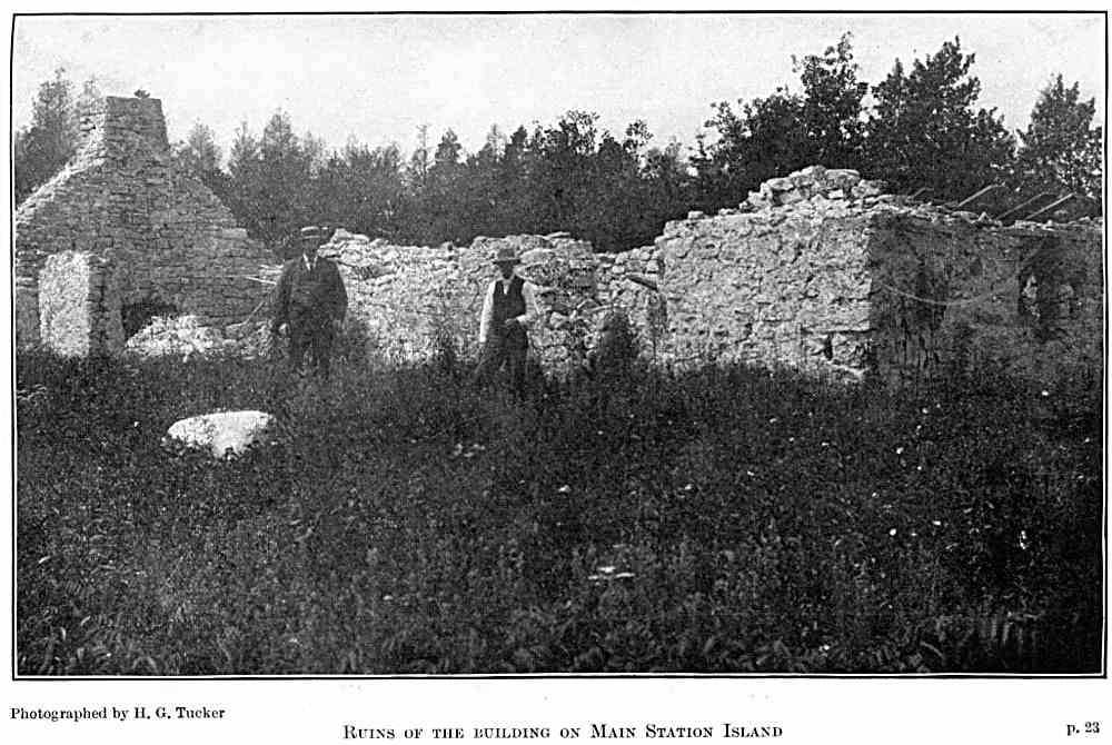
satisfactory financial basis, he creeled on Main Station Island a
substantial stone building, measuring 57 x 18 feet externally, whose
massive walls, now in partial ruin, evidence the character of the masonry
of those days. An effort has been made by some writers to associate these
ruins with the presence of the French in this part of the province in the
seventeenth century. The arguments urged in support of this view may apply
to the remains of the forts mentioned in the first part of this chapter,
but as regards the ruins on Main Station Island, the writer has the word
of Capt. A. Murray MacGregor, that he, as a boy, visited the Island
shortly after the buildings had been erected by his father, Capt.
Alexander MacGregor. The author also has conversed with several persons
who remember when the roof on the building was extant. Statements such as
these, definite and clear, must assure the reader that these ruined walls
are the remains of the first permanent building erected in the county of
Bruce, and that to Capt. Alexander MacGregor belongs the credit of having
erected them. [The question should be considered settled by what is said
in the following extract from the report of Alex. Murray, Assistant
Provincial Geologist, when referring to his survey of this part of the
province in the year 1848, he says: "With the exception of a building
which was raised some years ago by a fishing company at Gaheto, or Pishing
Islands, there is not a single dwelling on any part of the coast all the
way (from the Saugeen River) to Cape Hurd."]
The financial success met with by Capt.
MacGregor in his contract with the Detroit company was so great that a
feeling of envy was developed among, his fellow townsmen, combined with a
desire to participate in his fortunate discovery and grasp the profits
thereof. This was manifested by certain representations made to the
government to the effect that Americans were obtaining an undue advantage
by the exclusive contract they had obtained in these fisheries in Canadian
waters. As the result of these representations, a lease was granted to a
company, conferring to it the sole right of fishing at these islands.
Among the promoters of the company we find the names of W. S. Gooding, Dr.
William Dunlop, Dr. Hamilton, and others, of Goderich. As a result of the
granting of these exclusive privileges, Capt. MacGregor was compelled to
give up the fishing-industry he had developed and begin work anew
elsewhere. The search for fishing grounds equally as good was, however, in
vain. He first tried the vicinity of Tobermory, than Cape Croker. With the
latter place his name will be forever associated in the local appellation
bestowed of "MacGregor's Harbor." Finally he tried the fisheries in the
neighborhood of the Manitoulin Islands. But none of these proved as
remunerative as his first discovery. This pioneer of the fishing
industries of the county of Bruce lies buried near the mouth of the White
Fish River, a stream that flows into the North Channel, Manitoulin
Islands. The "Niagara
Fishing Company" was the name borne by the company above referred to. For
some reason it did not meet with the same success as had rewarded the
labors of Capt. MacGregor, so in 1848, having found a purchaser in the
persons of Capt. John Spence and Capt. Wm. Kennedy, of Southampton, the
company disposed of its property and privileges for the sum of eight or
nine hundred pounds. These two men jointly carried on the fisheries at the
Islands for several years, until Capt. Kennedy was called away, in 1852,
to engage in a polar expedition.

The first permanent settlers to take up land
in the county of Bruce did so in the year 1848. Less than a dozen
locations were made in the whole county in that the first year of actual
settlement. They who then became settlers well deserve the name of
pioneers. Miles and miles of forest lay between them and the most ordinary
comforts of civilized life; over these long and weary miles every pound of
the necessary supplies of food had to be carried until, after months of
hard labor and much privation, these stout-hearted men had brought their
land into a condition to produce something on which they could subsist
while the work of underbrushing, chopping, logging and clearing the land
went on. To fully appreciate what these and most of our pioneers have
endured, it would be necessary to call upon your imagination and picture
yourself in their place. Let us try to follow one of these stalwart men as
he leaves some outpost of civilized life and starts out into the bush, in
search of a location on which he may settle, clear a few acres of land,
erect a shanty, and thereby establish a squatter's claim to the lot of his
choice. Before he starts he carefully prepares the pack he has to carry.
This contains a supply of provisions, a few necessary cooking and eating
utensils, a blanket, an axe, and possibly an auger and a chisel; some, in
addition to these necessaries, took also a gun. After a weary tramp
through the woods along a surveyor's "blaze," a spot that seems somewhat
near the ideal he is looking for is reached. The land, he notes, is
covered with heavy hardwood timber, a safe indication that the ground on
which it grows is good; the soil, exposed where some ancient monarch of
the forest had stood, but now fallen and uprooted, seems all that could be
desired, and a spring flowing clear and cool fairly captivates him. Here
his search ceases. After securing his provisions in the hollow of some
tree, so they may be safe from rain or the depredations of wild animals,
he proceeds to do some underbrushing, and erect a shack or shanty, which
has to be made of timber of such a size that he unaided can lift it into
place. Cutting the logs into suitable lengths and notching each one for
the corners, he erects after much hard work his shanty. A narrow opening
is made for a doorway; planks split from cedar logs are made into a door.
The chinks between the logs are filled with splints and stuffed with moss
or clay. The roof is covered with elm bark. His bed of hemlock boughs is
placed in one of the corners. The table is made by driving four crotched
sticks into the earthen floor, on which rest, supported by cross-pieces, a
couple of split or hewed planks. With a block of wood for a seat, his
furniture is complete. The cooking, if it is summer, is carried on out of
doors, gipsy fashion; what is done is of the simplest—flour mixed with
water and a little salt is made into bannocks or scones, which are baked
in a frying pan. These and a cup of tea are the common articles of his
fare. Dwelling in such a structure, for the word "house" is hardly
applicable to it, the hardy backwoodsman proceeds with the work of making
a clearing, persevering thereat until want of provisions compels him to go
back to the settlement for a fresh supply. Only those who have experienced
it know the intense feeling of loneliness that oppresses the solitary
backwoodsman, dwelling alone in the bush—no one to speak to, or ask for
the most trivial assistance, the sound of a human voice is longed for, but
vainly. Inanimate nature in the forest gives forth sounds in the minor
key, both soft and soothing; the ringing sound of the axe as it makes the
white chips fly is cheery; the rush and crash of some giant of the forest
as it falls before the blows of the woodsman is exciting, yet these voices
of the backwoods fail to dispel the sense of loneliness which is one of
the most trying experiences of pioneer life. Individual instances of
hardships endured and of difficulties overcome by pioneers will be given
in relating the settlement of various localities within the county.
Therefore, without further ado for the present, we will pass on to
consider the disputed topic, to whom belongs the distinction of being the
first pioneer settler in the county.
Kincardine and Southampton are the only
localities in the county to claim that the initial settlement of Bruce was
made within their borders. As to which had precedence we leave the reader
to judge, after a consideration of the most reliable data that the author
has been able to collate.
Shortly after the opening of navigation in
1848, Capt. Murray MacGregor conveyed from Goderich in his sailing vessel,
and landed at the mouth of the Penetangore River, the two pioneer settlers
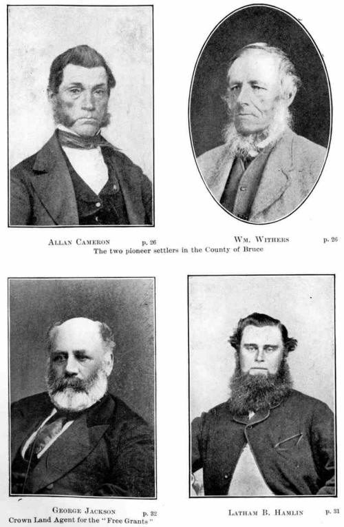
of that locality, with their effects. These two men were William Withers,
an Englishman, and his brother-in-law, Allan Cameron. [Owing to his dark
complexion his name was generally prefixed by the early settlers with the
distinguishing title of "Black," or "The Black Prince." ] On a spot a
little south of where the Kincardine railway station now stands, these two
men erected a small log house, which for a year or two did duty as a
tavern, kept by Cameron; subsequently it was used as a store by John
Keyworth, and as such may be remembered by many who traded in Kincardine
during the "fifties." Foreseeing the demand that there would be for lumber
as soon as settlers commenced to take up land, Mr. Withers commenced the
construction of a mill-dam, which he placed across the river about where
it touches the east side of Huron Terrace Street, [At what is marked in
original plan of the town as 'Mill Block No. 1.''] in the town plot of
Kincardine. Here he erected a frame saw mill, at the raising of which
assistance was rendered by Indians and the few settlers who had taken up
land in the vicinity. Mr. A. P. Brough, in his report of survey, refers to
this mill as "a substantial, well-framed building, which was in full
operation in the summer of 1849." When Mr. Withers erected his mill and
dam he neglected to secure permission from the Crown to do so; this
oversight resulted unfortunately for himself, he being forced, at a
considerable loss, to remove his newly erected mill from the site where
first erected to one on his farm (lot 3, con. 2, S.D.R., Kincardine), just
outside the townplot, the exact date of his doing so the author being
unable to find out. [In the Crown Lands Department records is a copy of a
letter to J. Clark, C.L., agent at Goderich, dated 14th February, 1850, to
the following effect: "You will also warn the person who contemplates
purchasing Mr. Withers' interest in the Mill-site, that when open for sale
the unauthorized occupation of the land will confer no rights to
pre-emption."] Mr. Withers had further difficulty in regard to cutting
timber on Crown lands. The lands in Penetangore and vicinity were not
offered for sale by the Crown until August, 1851, so that any timber cut
by him prior to that date was cut on Crown lands, [Extract from letter of
the Commissioner of Crown Lands to H. Clark, C.L., agent at Goderich,
dated September 29th, 1848: "I take this opportunity of informing you that
the road leading to Lake Huron, through the now townships in the north of
the Huron District, will not be carried through this year, and it is not
the intention of the Government to offer for sale at present the Crown
Lands in that section of the province."] and subject to Crown dues, which
the Crown Lands Agent at Goderich was told (Dec. 14th, 1848) to take steps
to collect or have the timber seized.
The first settlement at Southampton was made
by Capt. John Spence and Capt. William Kennedy. The former of these was a
native of the Orkney Islands; the latter was a well educated half-breed.
Both of these men had been in the employ of the Hudson's Bay Company, from
which service they had retired in 1847 and taken up their residence at
Kingston. Learning of the profitableness of the Lake Huron fisheries and
of the opportunities for trading in furs, in the spring of 1848 they left
Kingston westward bound, for the purpose of investigating for themselves
as to the truth of what they had heard; travelling via Toronto and Lake
Simcoe, at Rama they purchased a canoe from the Indians, in which they
journeyed down the Severn River to the Georgian Bay and thereon to Owen
Sound; from this point they travelled on foot by the Indian trail to the
mouth of the Saugeen River, arriving there in June, 1848. Satisfied with
the location and their prospects there, they returned to Owen Sound to
obtain supplies; with these they loaded their canoe and in it proceeded to
follow the coast line until the head of Colpoy's Bay was reached. Being
old Hudson's Bay Company voyageurs, the necessary portage to Boat Lake was
expeditiously made, the sail down Rankin and Sauble Rivers safely
accomplished, and it took but a short time to paddle over the waters of
Lake Huron to the Saugeen. Close to its mouth they pitched their tent and
in it resided all that summer. Before winter set in they erected a log
house, which served Capt. Spence and family as a residence for many years.
The stay of Capt. Kennedy in Southampton extended over only some four
years. In 1852, at the request of Lady Franklin, he went out in charge of
a party in search of her husband, Sir John Franklin, the Arctic discoverer
and navigator. In 1850 Capt. Spence brought his wife to his new home at
Southampton, where they continued to reside until the death of Capt.
Spence on October 13th, 1904. Mrs. Spence, surviving her husband, is
to-day one of the oldest living of the early female settlers of the county
of Bruce. Early in
the fall of 1848 John C. Digman, a German by birth, settled in Kincardine
Township, on lot 3, first concession north of the Durham Road, he being
the pioneer settler on the free grant lands. The date of his settlement
shows that he must have acted promptly after the issuing of the offer of
the Crown. How long Mr. Digman resided on the lot he located the writer is
not able to say, certainly long enough to have the Crown patent issued to
him, the date of which is December 4th, 1851. Some time after that he
returned to the county of Waterloo, from whence he originally came.
The next settler on the Durham Road was John
Beatty, a young Scotchman. He was accompanied by his sister, Miss Beatty,
who is entitled to the distinction of being, in all probability, the first
woman to undertake the hardships of the bush in the county of Bruce. The
facts here related concerning Mr. and Miss Beatty have been supplied by
Major William Daniel, who, when he settled in Kincardine Township in
October, 1848 (on lot 23, con. 1, N.D.R.), found that they were his
nearest neighbors. The Beattys had come on foot from Owen Sound, each
carrying a pack. Their route had been by the Indian trail (known later as
the "Gimby trail") to the mouth of the Saugeen, thence by the beach to
Kincardine. They pitched their tent towards the rear of lot 14, con. 1,
S.D.R., on the bank of the creek, it being the attraction that decided
them to locate there. "When the stock of provisions in our two camps were
almost exhausted," the Major goes on to relate, "I shared my last loaf
with them and started for my father's home in Waterloo for further
supplies, expecting to find my neighbors on my return. Beatty had arranged
with a man who was going to Goderich for the purchase of a supply of
flour. The man to whom the commission was entrusted made other use of the
money, consequently no flour was forthcoming. As winter was at hand, the
outlook for the Beattys was alarming. Feeling discouraged and
disheartened, they decided to forsake bush life and return to Owen Sound.
A young man named Dick Eaton, who was employed by Wm. Withers as ox
teamster, accompanied them on their journey, which was over the same route
they had so laboriously travelled not many weeks previously. The weather
was cold; through the streams to which they came they waded, carrying Miss
Beatty, except at the Saugeen, over which they were ferried by Indians in
a canoe. Eaton unfortunately cut his foot with an axe, and had to be left
in charge of the Indians." During the summer of 1848 the small settlement
at Kincardine was increased by the incoming of some dozen other settlers,
who took up land either at the town plot, on the free grants, or on the
lake shore to the north of the town. Among these were Donald, Alexander
and John McCaskill, James and Alexander Munroe, Anthony Copp, Alex. McKay,
George McLeod, Wm. Dowell and Patrick Downie. The last-mentioned opened a
tavern on the site of the Rightmeyer Salt Block. During the fall of this
year a steamer laden with supplies for the Bruce Mines was burnt somewhere
out in the lake. The wreckage from it, consisting of flour and provisions,
drifted ashore, and proved a perfect godsend to those early pioneers, who
that winter had to purchase from their slender means all their supplies in
Goderich, added to which was the time and labor of bringing these over the
intervening thirty-six miles, absolutely devoid of anything that might be
called a road for most of the distance.
Early in the year 1849 settlers in increased
numbers took up lands in the vicinity of Kincardine, of whom quite a
number survive. One of these is Elijah Miller. The 6th February of that
year is the day when he, then but a boy, first saw Kincardine. He, with
his father, mother, uncle and aunt, were driven over the ice from Goderich
by Capt. Thomas Dancey. To him it seemed that nothing was to be seen but
woods everywhere. The clearings that had been made were so small and
scattered that the forest appeared to have lost nothing of its unbroken
vastness. Mr. Miller, sen., settled on lot 12, con. 1, N.D.R. That winter
he made a small clearing and thereon raised a small crop the following
summer. Capt. Duncan
Rowan is another "forty-niner," who when alive was ever ready to speak of
pioneer days. He reached Kincardine on February 18th, 1849, accompanied by
his brother John and his sister, afterwards Mrs. McLeod.[The mother of
Angus McLeod, one of Canada's noted professional bicyclists. His mile with
flying start in 1 minute 46 and a fraction of seconds still stands as a
record on Canadian tracks.] They put up for the night at Patrick Downie's.
There they learned of Stoney Island, three miles farther north, as a place
where small vessels might find a haven. This, to one possessing the
instincts and training of a sailor, was attractive; in addition, good
farming land was to be had in the adjacent Lake Range, already surveyed.
Appreciating these advantages the party decided that on some of these farm
lots they would settle. Next day they yoked their oxen and journeyed on to
the spot that they had decided upon. Before long they had erected near the
beach, a log house, the site of which can be identified by the ruins of
the chimney. It was a familiar sight to all who passed up and clown on the
Beach Road in the "fifties.''
In the roll of the early pioneers of the
county the names of those who settled in the township of Huron must not be
forgotten, the date of their settlement being as early as many of those
already referred to. The survey of the first concession and the Lake Range
in that township in 1847, as mentioned in a previous chapter, had prepared
the way for those desirous of taking up land. An exactness as to date of
settlement is possible respecting the township of Huron not to be had so
authoritively in the case of other townships, as it is based upon a report
made by E. R. Jones, P.L.S., who after completing the survey of that part
of the township untouched by A. Wilkinson, made a list of all settlers on
the Lake Range, giving the date of settlement and extent of improvements
made up to the date of his report, Sept. 11th, 1851. From this report we
learn that in October, 1848, Louis Lizars settled on lots 47 and 48, Lake
Range, and was followed in the May of 1849 by Abraham Holmes, Wm. Blair,
Peter Wanamaker, James Donnelly and David Walden. The fall of the same
year added to the number of settlers in the persons of Joseph and
Christopher R. Barker, John Emmer-ton, Thomas and Elisha Barnes. The
foregoing names and dates are beyond dispute, but it is said that Louis
Bellemore, a French-Canadian, was the first to locate in Huron, and the
summer of 1848 is given as the time when he "squatted" on lot 19, beside
Pine River, where he made some improvements and kept a tavern. In the
following spring he sold his squatter's rights to David Walden and moved
to lot 36, and at the time of E. R. Jones-' report, he had made a clearing
thereon of thirteen acres in extent. [Bellemore at one time had been in
the employ of the Hudson's Bay Company, and had married the daughter of an
Indian chief. The sign of the tavern which he kept had painted thereon, in
rather rude artistic style, a bottle and a glass, with the motto, "A
French Tavern."] Among the foregoing names that of (Capt.) Abraham Holmes
deserves more than a passing mention. He owned and sailed a dug-out canoe
of unusual size, having a carrying capacity of five barrels of flour in
addition to its crew of two men, who, using oars and sails, brought many a
settler with their effects from Goderich to Penetangore. For several years
this vessel sailed regularly on this route.
Other pioneers took up land in Huron in 1849,
besides those on the lake shore. The first concession received its first
settlers in October of that year, who located near what is now Lochalsh,
Duncan McRae, Finlay McLennan and Alex. McRae, with their families,
coining in at that time. One cannot but admire the courage of these men
and women in taking up land miles back from the lake, in the midst of the
bush. If severe hardships fell to the lot of those who had the advantage
of water transit to reach their base of supplies, how much more severe
must have been the hardships endured by these families. It is pleasing to
be able to record that "Big" Duncan McRae is still living, and has passed
his jubilee on the same farm lot.
The rapidity with which the county of Bruce
was settled may be largely attributed to the offer made by the government
of a free grant, to actual settlers, of a fifty acre farm lot [806 lots in
all were so offered in the townships in the county of Bruce.] on either of
the first two concessions north or south of the Durham Road. This was
accompanied with the promise that this road would be cleared and opened up
by the Government. The third concessions were at first intended to be held
for sale to those who had obtained a grant. This intention was not,
however, adhered to. The prospect of purchasing additional land had the
effect of inducing many to locate on the second concessions, doing so
under the condition that they were to open up the road between the second
and third concessions unaided by the government; and until this was
satisfactorily done they could not obtain the patent to their grant.
The notice that the "free grants" were open
for location was made in August, 1848, and renewed in June, 1849. The mode
of taking up these grants and the conditions attached before a patent from
the Crown thereto could be obtained, are given in Appendices D and E, but
will here be related in a more detailed manner.
A personal application [The applicants were so
numerous in the summer of 1849 and 1850 that they could with difficulty
find accommodation in Durham, and were glad to sleep anywhere, as long as
they had a roof over their heads.] to the Crown Lands Agent at Durham, the
late Mr. George Jackson, [George Jackson, although residing at Durham, was
closely connected with the early days of Bruce and Walkerton. His name was
also well known to all settlers along the length of the Durham Road. The
few condensed particulars of his life here given are, therefore, quite in
order. George Jackson was born at Hutton, Yorkshire, England, in December,
1809. He came to Canada in 1844. The appointment of Crown Land Agent (see
Appendix E) for the Free Grants in Bruce and Grey was conferred upon him
in August, 1848. He was elected member of parliament in 1854 for the
county of Grey, being the first representative from that county. With the
exception of two parliaments, he continued to represent that constituency
until 1882. Mr. Jackson exercised discretion and judgment in allotting
settlers their free grants in Bruce, and was much respected and admired by
both friends and opponents. He died March 6th, 1885.] was necessary. Mr.
Jackson gave to each applicant a list consisting of certain lots not taken
up. These lists did not contain many lots, and were drawn out as far as
possible with a view of preventing two men inspecting and selecting the
same lands. Mr. Jackson also planned to have people of a congenial type
settle in close proximity; in this he was assisted by those whom he had
acting in the sense of sub-agents, from whom the land-seekers were
instructed to receive directions as to the locality of the lots on their
lists. In Kincardine Township Allan Cameron and Thomas Harris so acted,
and in Brant Thomas Adair and William Johnston—who received his sobriquet
of "King Johnston" in consequence from the hands of Mr. Jackson, a title
that clung to him for life. The applicant started off from Durham with the
list in his pocket and in his pack a supply of provisions sufficient to
last until his return to the clearings. Striking out along the Durham
Line, which at the first was only a blazed path through the woods, after a
good four hours' tramp he would reach the Saugeen River just west of the
county line, [This part of the Durham line was chopped, but not logged,
during the summer of 1849. ] at Buck's Crossing, where the village of
Hanover now stands. If the water were low he could wade across the river,
otherwise he had to follow up the stream in a northerly direction for
about a mile to where the mill-dam was afterwards erected. There a jam of
driftwood had formed, over which he crossed. This jam continued to be thus
used until the government had constructed a bridge on the line of the
Durham Road, in the fall of 1850. The land-seeker now entered upon a weary
march pursuing his search for a suitable lot, sleeping at nights in the
open when distant from any settler's shanty, or meeting with a warm and
kindly hospitality if he were so fortunate as to reach one. At last,
having made his selection, he returned to Durham, to have it registered to
him. From one to three month's grace were allowed before he commenced to
fulfil the conditions and make the improvements required by the Crown.
These stipulated continuous settlement, the clearing of twelve acres in
not less than four years, and the erection of a dwelling house of at least
18 x 24 feet in dimensions. These terms complied with, a patent to the
land was granted by the Crown. Conditions so easy were in many cases
performed long before the four years' limit of time expired, as is
instanced in Kincardine Township, where to settlers on the "free grants"
patents to the number of a dozen or more were issued in the year 1851. It
is possible, however, that politics were at the bottom of this early issue
of patents, as in those days a voter was liable to be called upon to
produce his title deeds when he tendered his vote for a member of
parliament; and it has been asserted, by parties who should know, that
only those men who were known to vote right received their patents early.
The first notice of the opening of the "free
grants" was issued by Crown Land Agent George Jackson, as already stated,
in August, 1848. This action on his part seems to have been premature, as
we find that the Commissioner of Crown Lands wrote to him under date of
October 12th, 1848, notifying him, "That neither location tickets can
issue, nor sales be confirmed, until the surveys are completed and the
Department be in a position to make records." This was followed, June
13th, 1849, by another letter instructing him to make returns of locations
on the Durham Road " in the township of Brant, the surveys of which are
completed," in order that location tickets may be issued. Also, "That to
comply with the statute passed at last session (12 Vic, chap. 31., sec.
4.), to suspend for the present the sale on the third Ranges of the 150
acres adjoining the free grants of 50 acres." The notice of the opening of
the "free grants" seems to have been renewed on the receipt of this last
letter. During the interval a number of squatters had settled upon the
free grant lots, and seem to have succeeded in having their names entered
as locatees in anticipation of the Departmental regulations. The first
were those in Kincardine Township, already referred to. Early in the
spring of 1849 intending settlers commenced to flow into Brant. The first
to do so was Joseph L. Lamont, [Mr. Lamont must share the honor of being
the pioneer of Brant with his wife, nee Elizabeth Jasper, who was the
first white woman to enter the township, although not the first to enter
to reside there permanently (that honor belongs to Mrs. James Bacon).
While still Miss Jasper she paid her father a visit, while he was engaged
in making a clearing on his lot, and to do so had to cross the Saugeen on
ox-back.] Thomas Weir and John Brown. This was early in May, 1849. On
presenting themselves at Mr. Jackson's office he told them that as they
were the first prospectors they might select any lots they thought best.
They spent three days in the bush engaged in making their selections.
Returning to Mr. Jackson to register the lots chosen, they met Thomas
Jasper and Abraham Buck, who formed the second contingent of would-be
settlers, preparing to leave and do as they had done, select a farm lot in
the bush. These two did not go as far into the woods as the first party
had done, Mr. Jasper selecting lands but a short distance west of the
county line, while Buck took up a lot just east of it. His name is
associated with what is now the village of Hanover, the locality at first
bearing the name of "Buck's Crossing," and, after the erection of the
bridge, as "Buck's Bridge." The next party of prospectors to enter Brant
consisted of William Johnston, Charles Nelles and James Purdy. These men
followed almost immediately those already mentioned, the date when their
lots [Johnston, in his own name and that of his sons, took up lots 5, 6
and 7, on both concessions, north and south of the Durham Road. Nelles, in
like manner, took up lots 1 and 2, concession 1, S.D.R., and Purdy, lots 1
and 2, concession 1, N.D.R.] were allotted to them being May 22nd, 1849.
Purdy did enough work on his lots that spring to ensure his claim, then
returned to the settlements, where he died during the summer. His lots
were taken up for a second time that fall by George Neely. William
Johnston spent the summer clearing land and erecting a fair-sized shanty
for his family, which he brought into the bush in the following November.
As all pretensions to a road or tract through the woods ceased at Bucks
Crossing, he constructed a good-sized raft of logs at the jam on the
Saugeen already referred to, on which he placed his wife, two daughters
[Who were subsequently married to William Walker and William C. Moffatt,
respectively.] and two of his sons, Andrew and Samuel. Jos. L. Lamont and
Geo. Weir were also on the raft, to act as crew. The number of persons,
with its cargo of household effects and farm implements, made the raft
unwieldy, resulting in its being stranded in one of the rapids that it
attempted to pass through. As soon as their position was realized, the two
men set to work and put together the waggon that formed part of the cargo;
on this the women folks were drawn to the shore. The raft so lightened now
floated, and was successfully navigated down the river as far as Silver
Creek. There it was met by Mr. Johnston and his sons, Abraham, David,
William and Robert, who had walked through the bush driving the cattle.
Some Indians were camping near by; these Mr. Johnston engaged to go up the
river in a canoe and fetch the women folks and Mr. Lamont, who had
remained with them. From Silver Creek to Johnston's Corners ["Johnston's
Corners" is the name that will always be given to the corner at which Mr
Johnston located. He there, in 1854, erected a tavern, subsequently burnt
down. His son, Nathaniel, born June, 1850, was first white child born in
Brant. Mr. Johynston's death took place September 22nd, 1870.] the axe had
frequently to be used to make the way at all possible. Mrs. Johnston and
some of the children were the guests that night at James Bacon's, his
family having moved in shortly before. To Mrs. Bacon is due the honor of
being the first white woman to take up her residence in Brant.
About the time Wm. Johnston took up the free
grant lots he afterwards settled upon, another prospecting party, six in
number, entered Brant. In this party were Thomas Adair, Kenneth Kemp and
Adam Clement. The latter quickly made his selection (which were lots 51,
52, 53, con. 1, N.D.R., and 53, 54, con. 1, S.D.R.), not considering it
worth while to push on any great distance into the bush. Mr. Adair
prospected further and was influenced in his choice of lots (43 to 46,
con. 2, N.D.R.) on the "North line" by the expectation of purchasing more
land across the road in the third concession. On registering his location
(June 3rd, 1849) he found but sixteen lots had been taken up in Brant. Mr.
Adair, accompanied by his brother John, returned to make a clearing on
their lots in the following September. Being expert woodsmen, they soon
had a comfortable shanty erected, in which they resided until the snow
came, when they returned to their families near Peterborough to complete
arrangements to bring them to their new home in the woods of Bruce. The
journey was long and toilsome. The sleighs on which their effects were
packed could be brought no further than Buck's Crossing; from that point
everything had to be shouldered and carried through the snow over the
weary miles that lay between them and their shanty. Their mother was an
invalid; it was therefore necessary to improvise a sedan chair, on which
she was carried over what was but a footpath in the deep snow. But slow
progress could be made, and half a day was occupied in reaching the small
but hospitable shanty of Adam Clement, in which sixteen persons were
accommodated that night. Next morning the journey was completed, and they
reached their own shanty, two miles further back in the woods.
The number of settlers who came into Brant in
1849 the writer is not. able to state. Among them were the following, in
addition to those elsewhere mentioned: Archibald, Alexander and Moses
Stewart, John Lundy, Thomas Todd, Joseph L. Lamont, John Brown, William
and Johnston Smith, William Jasper, Edward Boulton, Patrick Godfrey,
Richard Everett, and others.
In the year 1849 lands were also taken up in
Greenock, where the village of Riversdale now stands, by two
French-Canadians, Joseph Chartrand and John Caskanette. These men were in
the employ of A. P. Brough, P.L.S., during the survey of the Durham Road,
the township of Brant and the Elora Road. The exact date of their settling
on the lots they selected is uncertain. The author has' conversed with
them on the subject, but found their recollections lacking in
definiteness. Goderich was their base of supplies, a point more than fifty
miles distant. A
tragic incident marked the early days of the settlement of the Durham
Road, too often repeated in varying details during the clearing away of
the forest here and in other parts of the province. Thomas Jasper, as. is
stated in a previous paragraph, was in the second company of prospectors
that entered Brant. He then took up lot 65, con. 1, N.D.R., as well as
other lots for various members of his family. Previous to entering the
bush he had resided at Durham, or Bentinck, as it was known in those days.
It was in June, 1849, when, accompanied by his sons, Thomas and Charles,
he commenced making his clearing. Satisfactory progress was being made.
One morning in the following month the father and his two sons started out
to do some chopping before breakfast. The young men were engaged in
felling a tree, and the father, not far off, was cutting some underbrush,
a small knoll hiding him from their sight. From the sound of his axe they
knew that he was close at hand; they therefore called out to him to look
out, when the tree they were chopping was almost ready to fall, repeating
it a little later on, "which warnings he answered to. The tree felled, the
young men as they started for their shanty to get breakfast called out to
the father to come along. Receiving no reply they felt alarmed. A search
was made, which revealed the shocking sight of his dead body held under a
wide-spreading branch of the tree they had just cut down. He had been
struck and killed instantly, the first of many a pioneer in Bruce to meet
death as he wrought at making a home for himself in the woods. His body
lies buried not far from where he died.
In closing this chapter on the pioneers, the
author wishes it to be borne in mind that the names mentioned are of those
who came into Bruce prior to the year 1850, who came so early in the
history of the county that not even one township within its boundaries had
been surveyed into farm lots. Thousands followed in their footsteps, of
whom many will be referred to when the history of the various
municipalities is taken up, as their pioneers. The author does not
underestimate what labor and hardships these later ones have experienced.
But he does bespeak a special word of appreciation for the pioneers of
1848 and 1849, men who entered a trackless forest, and who then and there
laid the foundation of the county's development and prosperity.
"When the hill of toil was steepest,
When the forest-frown was deepest,
Poor, but young, you hastened here;
Came where solid hope was cheapest—-
Came—a pioneer.
Made the western jungles view
Civilization's charms;
Grasped a home for yours and you
From the lean tree-arms.
Toil had never cause to doubt you—
Progress' path you helped to clear;
But to-day forgets about you,
And the world rides on without you—
Sleep, old pioneer!"
—Will Carleton. |