|
“Our hearts are as free
as the rivers that flow
To the seas where the north star shines,
Our lives are as free as the breezes that blow
Thro’ the crests of our native pines.”
Robert K. Kernighan
THE map of Algoma shows
a vast territory, stretching some three hundred and sixty miles
northwards from “the Soo” to the Albany River. Its southern portion is
checkered with townships, already numerous enough to make several
counties after the pattern of those of old Ontario, but bearing a small
proportion to the huge blank spaces of the north, marked only with the
names of the lakes and rivers that plentifully water that “Great Lone
Land.” The lines of the townships run on the north into the larger
oblong of the Mississauga Forest Reserve. Indirectly the Canadian
Pacific Railway’s advertising agents had a hand in the setting apart of
the vast reserve by calling the attention of "canoe travellers” to the
Mississauga River. This flows through a large block of pine timber, and
the authorities, fearing that the coming of tourists would cause
increased danger of forest fires, decided to take measures to protect
the valuable pine. Accordingly, on February 24, 1904, an Order in
Council was passed, creating the Mississauga Forest Reserve, which
comprised about 2900 square miles.
Dotted along Algoma’s
two hundred miles or more of coast-line on Lakes Huron and Superior are
a few villages and towns, the largest and most important of which is the
historic Sault Ste. Marie, It was first visited, says Dr Bain, by the
French traders, who named the Indians Saulteaux, from the falls in the
St. Mary’s River.” Jesuit Fathers soon followed, and P6re Marquette
established a mission there in 1669. Two years later the Intendant Talon
sent Daumont de St. Lusson, accompanied by the interpreter, Perrot, to
seek for the copper mines, of which there were rumours, on Lake
Superior. The expenses of the expedition were to be paid by trading in
furs. St. Lusson wintered with the Indians, claiming in the name of his
Sovereign the whole land as far as the western and southern and northern
seas. As a visible token of these stupendous claims, a cross bearing the
Royal Arms was planted at Sault Ste. Marie, and the Jesuit Allouex
harangued the assembled Indians, representing several tribes, on the
power of the King of France. But the red men, probably actuated by
superstitious fears, pulled down the cross as soon as the backs of the
French were turned.
The troublesome
Iroquois caused the abandonment of the mission in 1689. Sixty-one years
later, La Jonqidere, then Governor of Canada, gave his nephew and the
Chevalier de Repentigny a grant six leagues square at Sault Ste. Marie,
so that—“at their own expense”— they might build a palisade fort to
prevent the Indians trading with the English. “The palisade was 110 feet
each way,” and enclosed three small houses and a “redoubt of oak 12 feet
square.” A Canadian, Jean Baptiste Caueau, or Cadot, was put in charge;
and there, long after the French lilies "had ceased to float over the
ramparts of Quebec,” this trader kept the old flag flying by St. Mary’s
River, though ultimately he accepted the changed situation, and even
fought gallantly for England. He had married an Indian woman “of great
force of character, energy, and uprightness,’’ and in his house only
Chippewa was spoken.
Alexander Henry visited
Cadot in 1762, and this notable trader and explorer was much interested
by the spectacle of the Indians—two in each canoe—scooping up whitefish
with a long-handled net from the turbulent waters of the rapids. At
times the fish (some of which weighed 15 lbs.) were so crowded together
in the water that a skilful fisherman could catch five hundred in two
hours, but some winters the usual supply of fish failed, and the traders
and Indians - had hard work to fight off starvation. Henry was at
Michillimackmac, or Mackinaw, during Pontiac’s war, when the fort was
taken by the Indians, but after many hair-breadth escapes he fell in
with Madame Cadot, who was on a journey, and with her reached Sault Ste.
Marie in safety. Two years later Henry took Cadot into partnership.
The story of the first
success in the War of 1812 belongs, in a sense, to the district of
Algoma. On St. Joseph's Island there was at that time a blockhouse
commanded by Captain Roberts, to whom Brock had sent orders that if war
were declared he was immediately to attack the American fort at
Mackinaw. Roberis had only forty-five regular soldiers available, but
traders and voyageurs eagerly volunteered, and the North-west Company
furnished the brig Caledonia as a transport. The surprise was so
complete that there was no bloodshed, and Mackinaw remained in British
hands till the end of the war.
Amongst the volunteers
was John Johnston, a well-to-do Irish trader of Sault Ste, Marie, who
had wedded a Chippewa, During his absence his house was raided and burnt
by Americans, while his wife and children looked on from the woods.
Later he took his wife and a daughter, a beautiful girl, home to
England. The Duke and Duchess of Northumberland were so charmed with the
latter that they wished to adopt her, but she preferred to return home,
and ultimately became the wife of Henry Schoolcraft, the famous
historian of the Indian tribes.
THE OLD LOCK AT SAULT ST. MARIE
Another pioneer who
took part in Roberts’ expedition, and had also married an Indian woman,
was Charles Ermatinger, a trader, of Swiss extraction. His post was on
the south side of the river, and in 1822 the Americans took possession
of it and made it into a fort, but afterwards gave compensation to its
owner, who had removed to the British side.
In the days of trouble
between the North-west Company and the X. Y. Company there was a hot
dispute over the portage past the rapids. The latter company, says Dr.
Bryce, “forced a road through the disputed river-frontage, while the
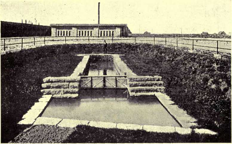
North-west Company used a canal half a mile long on which was built a
lock, and at the foot of the canal a good wharf and store.” Remains of
the tiny old lock are still to be seen, near an old blockhouse lately
used by the directors of the Algoma Steel Company for a lunch-room. The
voyageurs in their little boats often had perilous voyages along the
rugged coast of Lake Superior, to which clung many a legend of terror,
and not a few bold fellows went down to death in its chill depths. Here
and there along its grim shores were dotted little trading posts, that
at Michipicoten, where Henry once tried unsuccessfully to grow potatoes,
being within a few miles of what is now the western boundary of Algoma.
In 1870, when the Red
River expedition was working its difficult way westward, there was no
Canadian canal at Sault Ste. Marie by which vessels could pass the
rapids, and the Americans would not at first permit the force to use
their canal, built in 185 5, so guns and stores had all to be “portaged”
three miles and a half. After urgent remonstrances, however, the embargo
was removed, and then the American officers at Fort Brady became very
civil to the British officers. Of course, when the troops had embarked
for Sault Ste. Marie, that stately name was often on the lips of the
officers, and it was told that the old skipper of one of the steamboats
grew obviously uncomfortable at its repetition, and at last protested:
“Call it the Soo, sir—the Soo! . . . We always calls it the Soo; it’s
ever so much shorter, and everyone will understand ye!” And “the Soo” it
most often is to this day, when its population has passed 11,000. and
when millions of dollars are invested in its huge iron and steel works,
its great paper factories, and other vast industrial enterprises, to say
nothing of its world-famous canal.
To many people, indeed,
the canals are the most interesting feature of "the Soo.” It was in 1888
that the Dominion Parliament passed a measure for the building of the
canal which was to make Canada independent of the good-will of her
neighbour for the passage of her vessels between Lake Huron and Lake
Superior. Plans were at once prepared, but the engineer died before they
could be carried into effect.
For the lock the final
design was made in the autumn of 1892, and the contractors agreed to
complete it by 1894. But in the summer of 1893 the United States
Government ordered the collection of tolls on all vessels passing
through the American lock. Upon this the Dominion Government offered the
contractors a bonus of $90,000 to complete the work by the end of the
year, and, except for a very small portion, the whole of the walls of
the lock, from 20 to 25 feet in thickness, was built in five months, the
last stone being put in place on November 16, 1893. The lock is 40 feet
deep, 60 feet wide, and 900 feet long. Vessels go through as well by
night as day, only fog, which sometimes makes it hard to find the narrow
channel leading to the lock, stopping the procession. The canals on both
sides of the international boundary are now free to the vessels of both
nations. The larger vessels, however, often choose the Canadian canal,
and the tonnage which annually passes through it is three times as great
as that passing through the Suez Canal. |


