|
THE MOUNTAINS OF THE
ALEXANDRA ANGLE (Mistaya and North Fork Valleys. Pinto Pass and Lyell
Glaciers)
“There are none the
less moments of irrational passionate revoltmoments in which one would
buy back with a year of the life that is left one solitary hour among
the untroubled mountains of youth”
Arnold Lunn
It was the unfrequented
region surrounding Mount Columbia, a land almost “lost behind the
ranges,” which lured Dr. William Ladd and myself into joining forces on
our Expedition of 1923. During winter days we had spent hours in poring
over available maps and photographs, familiarizing ourselves as best we
could with the geography and history of North Saskatchewan headwaters.
We were to visit an area much less compact than the Freshfield Group,
with peaks carved on a vaster scale and more widely separated. It was
plain that the Columbia Icefield must be crossed, in part at least,
before climbs could be made; we knew that the distances were very great.
A further incentive was the fact that the mountains were situated near
the limits of journeys made by earlier explorers, whose observations had
frequently been made under conditions that precluded satisfactory
results. There would be work for us to complete.
The terminal branches
of the North Saskatchewan, as our map-dissection revealed, find their
sources chiefly in the eastward drainage of the Continental Divide,
between Howse Pass—in the northern Waputiks—and Mount Columbia. Mistaya
River, locally known as Bear Creek or the “Little Fork,” flows northward
from Bow Pass, receiving streams from the Waputik ice through Peyto
Glacier, and joining the main Saskatchewan between Mounts Sarbach and
Murchison.
Howse River, the
“Middle Fork,” flows from the Freshfield Group, and also receives
streams from Bush Pass, as well as from the Lyell Icefield through
Glacier Lake. The third branch, the North Fork, comes from Sunwapta
Pass, which, in the north, separates Saskatchewan from Athabaska
headwaters. The North Fork has its chief source in the Saskatchewan
tongue of the Columbia Icefield, but its volume is soon increased by
Alexandra River, its old “West Branch.”
Howse River and the
North Fork meet from almost opposite directions, and, turning abruptly
eastward, receive Mistaya River in a sharp angle from the south, the
combined stream finding exit to the plain through the portals between
Wilson and Murchison.
Something of the trails
in these valleys I had learned from the journey to the Freshfield Group;
but beyond the Saskatchewan Forks it was a vast unknown —although Ladd
and I, from peaks near Lake Louise, had seen the far mysterious
mountains of the north and had wished to make their closer acquaintance.
It seemed a shame that these beautiful snowy summits should have no
admirers but themselves.
Following the Divide
from Bush Pass, in a northward air-line of twenty miles, one reaches
Thompson Pass, crossing the Forbes-Lyell Group en route. There is no
magic carpet equal to a map for doing such a thing; in reality it would
be extremely difficult, for the Lyell Icefield system is a large one and
the glaciers of the Lyell massif1 alone occupy
more than thirty square miles. The icefield was discovered, as were so
many other topographical features of the region, by Dr. Hector. He had
gone there in behalf of the Palliser Expedition, in 1859, the year
preceding his visit to the Freshfield Group. Encamped at Glacier Lake,
he tells us,2 “Two hours, with the aid of the
track the men had hewn, brought us to the west end of the lake, where
there is a few miles’ extent of open grassy plain, fringed with wood,
intervening between the foot of the glacier and the water’s edge.
“Reserving the ascent
of the glacier for the next day, I ascended the south side of the
valley, and found it to be composed of deep blue lime-stone, full of
iron pyrites in nodules. Start at sunrise to ascend the glacier,
accompanied by Sutherland. The other men I sent off to hunt for sheep or
deer, of which we found a few tracks.” Then follows a paragraph,
entertaining, and preserving for us one of the few instances of
superstition of Canadian Indians regarding a mountainous area: “I wished
Nimrod [Dr. Hector’s chief hunter] to go with me, but he would not
venture on the ice, but told all sorts of stories of sad disasters that
had befallen those Indians that ever did so; how that, if they did not
get lost in a crevasse, they were at least sure to be unlucky afterwards
in their hunting.
“I saw now that the
glacier I was upon was a mere extension of a great mass of ice, that
enveloped the higher mountains to the west, being supplied partly
through a narrow spout-like cascade in the upper part of the valley, and
partly by the resolidifying of the fragments of the upper Mer de Glace,
falling over a precipice several hundred feet in height, to the brink of
which it was gradually pushed forward. A longitudinal crack divides the
glacier throughout nearly its entire length, sharply defining the ice
that has squeezed through the narrow chasm, from that portion of the
glacier that has been formed from the fallen fragments, the former being
clear and pure, while the latter is fouled by much debris resting on its
surface and mixed in its substance.
“The blue pinnacles of
ice, tottering over the brink of the cliff, were very striking, and it
was the noise of these falling that we had mistaken for thunder a few
days before when many miles down the valley. On coming fairly in view of
the precipice, when about two miles from the front of the glacier, I
found, by watching the fall of these pinnacles, and observing the
interval till the crash was heard, that I was a little more than four
miles distant, so that the lower part of the glacier is about six miles
in length. After examining the surface of the glacier, and arriving at
its upper end close to the precipice, we struck off to the north side of
the valley, to ascend a peak that looked more accessible than the other.
“Here we found traces
of where a bear had been digging roots of alpine plants. We started an
old goat, and got quite close to him, but not having a gun could do him
no harm. We had a splendid view over the Mer de Glace to the south and
west, the mountain valleys being quite obliterated, and the peaks and
ridges standing out like islands through the ice mantle.”
Mount Forbes was
unnamed in those days, but Dr. Hector saw it and recognized its
pre-eminence; for he goes on to say, “The mountains to the north are
very rugged, but not so high as those to the south of the valley. In
that direction there is one peak which has a pyramidal top completely
wrapped in snow, and at least double the height of where I stood.”
Dr. Hector’s narrative
is so accurately and clearly written that we found it quite worth while
to continue our delving. We learned that, after the pioneers, alpinists
came searching for these great mountains of the north. But they too were
forced to become explorers, since information was incomplete, and, in
many cases, incorrect. Coleman, in 1892, rediscovered Fortress Lake,
and, in the following year, visited Athabaska Pass. Wilcox, in 1896,
starting from Laggan, was the first white man to journey up the North
Fork and cross to the Athabaska. Collie and his companions had come out
from England, in 1897 visiting the Freshfield region, and in 1898
discovering the Columbia Icefield itself. Habel, the German explorer, to
whom we are indebted for calling attention to the beauty of the Yoho
Valley, in 1901 made an extensive study of the western sources of the
Athabaska, penetrating to the northern base of Columbia, calling it
“Gamma.” Sir James Outram, in 1902, with the guide Christian Kaufmann,
and accompanying Collie during a part of the season, accomplished a
series of great climbs, including first-ascents of Freshfield, Forbes,
Lyell, Alexandra, Bryce, and Columbia. Reasonable enough that we, too,
should have been attracted by these stories of such an alpine
Wonderland!
It was early in the
spring when we arranged our plans. Our outfitter, of course, would be no
other than Jim Simpson, who had taken Palmer and myself to the
Freshfield Group during the season preceding. Jim was quite keen to go
again into the north-country which he knows so well. He wrote to say
that Tommy, best of cooks, would be with us again; and that one, Ulysses
La Casse—because of his broad grin more conveniently known as
“Frog”—would come as horse-wrangler. Finally, and luckiest of all, we
secured the promise of Conrad Kain, super-guide and philosopher, whose
stories have since quieted our nerves over many a day of bad weather, to
lead us up the icefield peaks.
No one, for many years,
had visited the Thompson Pass area with climbing purpose; and, as there
remained an untouched twelve-thousand-foot peak on the Columbia field,
we could scarcely be expected to control our excitement. It was July
27th when we left Lake Louise with our procession of horses. We had
quite an audience, for the start of a pack-train is a thing not seen
every day. Such a commotion! Boxes and saddles; duffle bags and pans.
Squealing horses tethered in the scrub-pine, breaking loose now and then
and galloping through the clearing, bells clanging and pack-covers
flapping. The cayuse that is being packed —how sleepily he stands, with
belly forcibly distended lest the rope be too tight; the shrewd look in
his eye as an uncovered axe touches his rump. A heave and a buck;
profanity and the operation repeated ... off at last with the horses
fighting for their place in line.
Bow Lake, where
tumbling icefalls and sparkling water afford a setting in which many an
Izaak Walton has become oblivious of his sport, was reached on the
second day. Jim has a fine camp there now; a comfortable boat, brought
in from the railroad by pack-horses, a snug boat-house on the sandy
beach, and a regular block-house of logs where one could spend the most
restful sort of vacation. We recommend it.
On the day following,
we rode through the meadows leading in gentle slope to the summit of Bow
Pass, and down the Mistaya to campground on the Wildfowl Lakes. There we
pitched our tents, the nest of a ruby-throated humming-bird above our
door, and wandered along the lake shore where we could watch the antics
of sandpiper, wheeling and darting in broken flight, and harlequin duck
diving and rippling the calm-mirrored images of jagged ridge and
ice-hung peak.
Simpson and Ladd walked
down to the lower lake to investigate a cache of provisions in a little
cabin. I went part way along the lake to photograph and sat down to
admire the majesty of Howse Peak and the wall of the northern Waputiks.
A stiff breeze was blowing, catching up the water and whirling the
surface spray up into curious, transient waterspouts six and eight feet
high over a circle twenty feet in diameter. The boys were soon back,
reporting that a wolverene—the nightmare of winter trap-lines—had got
into the cabin, and made things the worse for his visitation.
Our next day of travel
was a delight. Between the lakes Mistaya River is forded, trail leading
to the Forks of the North Saskatchewan. We pass through Pyramid Camp,
where we had stopped a year before, our blaze still legible on the big
tree under which we had slept. The river foams and boils in a misty
canyon, far below; towers of Murchison rise across the valley like
shattered cathedrals; pack-horses are splashing through pools and
sloughs whose borders are riotous in flower colours. The trail is cut
and broken by turbulent glacial brooks, with soaring ice-clad peaks
above. An eagle soars from the cliff shadows, into blue space, guiding
us to the Saskatchewan.
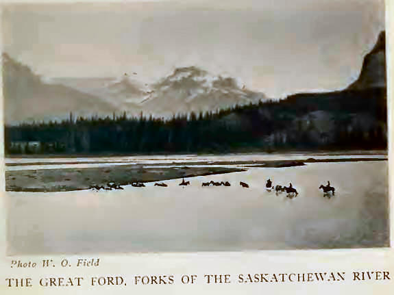
At the Forks, instead
of turning up Howse River, the entrance to the Freshfield Group, we
crossed the long ford and camped on the far bank below Mount Wilson. If
one is unlucky, at high water there will be swimming and wet packs. The
river flows between Murchison and Wilson, past the Kootenay Plain and,
continuing as Nelson River, connects Lake Winnipeg with far distant
Hudson Bay. Here, however, it is broken by gravel-bars into shallow
rapids, through which the horses struggle, while their riders make
futile attempts to remain dry-shod. Camp is splendidly situated on a
terrace, at the junction of the North Fork, Howse and Mistaya Rivers,
where in the long-ago the Indians came to tan and cure hides after their
hunting trips. The panorama is one of great beauty, strangely suggestive
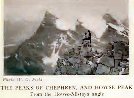
of the Oberland peaks from Grin-delwald—sky-soaring Chephren with its
pure white snow-saddle, ice-hung Kaufmann Peaks, and the rockwall of
Sarbach, massed in the Howse-Mistaya angle. A glimpse of the Lyell
Icefield through the gap of Glacier Lake, and the spire of Forbes, add
to a scene whose foreground is a river, lighted by the afternoon sun,
with horses grazing on the flats, and smoke rising through gnarled and
ancient trees.
In his journal, under
date of February 8, 1811, Alexander Henry (the younger) makes the
following entry: . . we came to the forks, where the river spread to
about half a mile wide, free from islands; but as usual in such places,
the bed was choked with bars of sand and gravel. Here a branch of the
Saskatchewan comes in from the N. opposite a smaller branch from the S.;
both appear contracted, winding their courses through mountains. The
main channel, up which our course lay, is still wide, and comes from the
W. At the junction of these forks we had a grand view of the mountains,
more elevated and craggy than any we had before seen. The upper parts of
some of them are curiously formed, some closely resemble citadels, round
towers, and pinnacles rising to a great height, with perpendicular
summits, so steep that no human being could ascend them. Some of the
highest remained all day enveloped in clouds, which were not dispersed
for several hours after the wind arose, and even then hovered upon the
summits as if loath to leave, until torn away by the violence of the
wind, which increased to a gale from the W. Upon the top of a mountain
N. W. of us, whose summit appeared level, I observed an immense field of
snow, of which a part seemed lately to have separated and fallen down.
This frequently happens during winter, when vast quantities of snow
accumulate till the mass projects beyond the rocks and then gives way.
The noise occasioned by the fall of such a body of snow equals an
explosion of thunder, and the avalanche sweeps away everything movable
in its course to the valleys. On the sides of some of the mountains S.
of us, where the rays of the sun never reach, are vast beds of eternal
snow, or, more properly, bodies of eternal ice, their bluish color
plainly distinguishing them from the snows of this season; some parts
have recently given way and fallen into the valleys, while the remainder
presents a perpendicular face of ice in strata of different thicknesses.
Here we saw the tracks of several herds of buffalo, which had crossed
the river.” —“New Light on the Early History of the greater North-West,”
Henry Thompson Journals, 1789-1814, Elliott Coues (F. P. Harper, New
York, 1897), Vol. II, p. 689.
The Forbes-Lyell Group
of mountains is separated into southern and northern divisions by the
Mons and Lyell Icefields, lying on the Continental Divide. The chief
peaks of the southern area are Forbes (11,902 feet), east of the Divide,
and Bush Mountain—Rostrum Peak (10,770 feet), and Icefall Peak (10,420
feet)—in British Columbia. Peaks of the Divide, north of Bush Pass,
Cambrai (10,380 feet), Messines (10,290 feet), and Mons (10,114 feet),
show what part the late war played in the nomenclature of the Northwest.
The northern division
extends from Mount Lyell to Thompson Pass (6511 feet), in the splendid
range encircling the head of Alexandra River. Lyell possesses five
peaks, all above 11,000 feet, from the central one of which the Divide
continues northward over Farbus, Oppy, and Douai, and rises to the
abrupt, snowy summits of Alexandra—11,214 feet, and 10,990 feet—whence
it crosses Fresnoy (10,730 feet), Spring Rice (10,745 feet), and
descends to Thompson Pass from the summit of Watchman Peak.
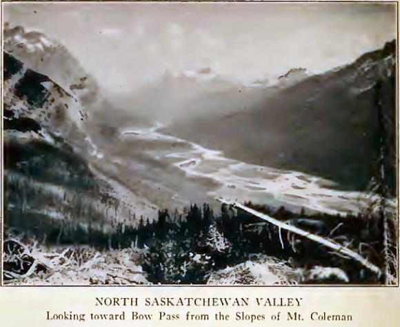
Morning came; daffodil
glow preceding a succession of delicate colours, and leading us up the
North Fork Valley. Bars of sunlight relieve the shadowy recesses of
primeval forest—cottonwood, poplar, and cedar—through which winds the
trail. Close to the cliffs of Mount Wilson, meandering streams,
suggesting lines of a jig-saw puzzle, gleam through the meadows. Tiny
fish dart in the shallows; and all the toads seem to be amphibious,
hopping into the water as our horses pass. Mount Saskatchewan, mirrored
in many a quiet pool, stands guardian of the entrance to Alexandra
River.
“Graveyard,“ because of
ancient hunting relics which adorn it, is the name given to the camping
place opposite the mouth of Alexandra River. A bit of buffalo skull,
white and friable, recalls the days when these huge animals ranged even
into the remote valleys of the north. Pinto Pass, with an old Indian
trail leading over the Cline4 River, may be reached in a few hours; Ladd
and I strolled out above it to the bench-land below Mount Coleman for a
far-reaching view of the Saskatchewan Valley. We sat down among the
forget-me-nots; Bow Pass could still be seen, a dim grey-blue saddle on
the southern skyline. We looked into Alexandra Valley where brilliant
light outlined the distant range. The sun was setting behind the
outlying pinnacles of Mount Saskatchewan—antique towers and
air-castles—while purple shadows lengthened in the gorge below, and
against this glorious background we watched three sheep, in silhouette
row, walk up a nearby ridge and disappear.
With the exception of a
few travellers and Indian hunters, there have been but few visitors to
the valley of Alexandra River. Locally known as the “West Branch,” the
first white men to gain even a partial view of it were Wilcox3
and Barrett who in 1896, en route to Fortress Lake, ascended a spur of
Mount Saskatchewan and looked up the river to its bend.
Based on information
from Tom Wilson, of Banff, that there was an Indian trail across the
pass at the valley-head, Mr. C. S. Thompson, an enthusiastic
mountaineer, in 1900, travelled as far as the pass now bearing his name.
He took one packer with him, and although no climbing was attempted
because of bad weather prevailing, they explored the pass and visited
the northern glaciers of Lyell.6
During the summer of
1900, Messrs. Collie, Spencer and Stutfield attempted to penetrate to
the Columbia Icefield by way of the Bush Valley and the western slope of
the mountains. C. S. Thompson at the same time went north by the
Saskatchewan Valley, hoping to locate Collie’s party by way of the pass
at the head of the “West Branch.”
The hardship of
pack-train travel on the British Columbia side of the Divide is
amusingly set forth in a letter, dated Dec. 31, 1902, from Collie’s
outfitter, Fred Stephens, to Mr. Walter D. Wilcox:
“Better late than Never
so as i Promised 3Tou; would Rite and tell you something of our Bush
River trip i will just give you a Pointer to Pass it By. We left Donald
and followed an old trail which Led through a Dence forest to the mouth
of Bush River. We apparently followed the Columbia but was out of sight
of it most of the time; never saw such undergrowth mud and wet, with
mosquitoes that would stop a syclone, the poor Englishmen looked like
Plum Puddings walking around with their faces swoolen up to twice their
Natural size. Well we wanted to get to the head of the Bush River but
found it in high water to be impossible to follow up the Bank. We took
the trail back 6 miles then climbed up over a mountain with the outfit
and struck the River 7 or 8 miles up. It was raining 7 days out of 6, to
make it more Pleasant. The Pack horses got covered with Brittish
Columbia mold, the oat meal soured, the hard tack swelled up so we had
to Pack our saddle horses. The wood would not burn and a few more things
went Rong. We finally got up the River far enough so it commenced to get
deep and the valley was Narrow and filled with Burnt fallen timber. We
There is still a faint
trail, with many crossings of the stream which divides and wanders
between little green islands, where birds hide and disclose their
presence only when one approaches closely. Alexandra and its tumbling
glacier-falls loomed ahead. Several deer bounded away when they got wind
of the horses. Little drab buffalo-birds followed us; friendly fellows
who like nothing better than a ride on the back of a cayuse. There are
many game tracks, but in the heat of the day the larger animals—deer,
moose, and sheep —are high up near timber-line where cooler breezes
drive off the flies. Just as the Freshfield area was the home of big
goats, so this and neighboring valleys form the territory of the sheep;
for sheep and goat are on unfriendly terms and do not range together.
We passed by Camp
Content, where Outram had stopped years before, and, crossing an angle
of the nearly drouned Harry Long because he could not ride a raft of
water soaked logs. We found it impossible to follow up the valley to the
foot of Mt. Bryce and Columbia so we took to the hills and camped 7000
above sea Level. Here it snowed for 4 days and the wind blowed so we had
to tie down the Pack Saddles to keep them in camp. I suppose this would
be Delightfull to you But somehow it dont catch me. This was as far as
we got although i could go mutch farther but the weather was so cloudy
that it was useless to go farther. Here we turned and came Back to
Donald. I think we were about Due west of the west Branch whitch comes
into the west fork of the Saskatchewan.
“I will wind this
interesting slip to a close; have no Doubt you would find this a very
interesting country to go to as the mountains are verry high and craggy.
The whole country is verry Rough and the weather in July will freeze a
kyote so I am sure you would call it Grand.” river, placed our tents
close to the Alexandra Glaciers, naming our stopping place—the reason
was obvious— “Last Grass Camp.” Mount Oppy (10,940 feet), with its
gabled ice-crest, rises with Alexandra above this spot, with the
northern Lyell basin close at hand. It was our intention to attack this
basin in the hope of attaining the Lyell-Farbus col and the unclimbed
Divide peak of Lyell (No. 3; 11,495 feet), just equal in height to the
central peak ascended by Outram. There also one might traverse the arete
of Farbus (10,550 feet), and across a steep little ice-col reach Mount
Oppy itself, peaks well guarded by icefalls above the Alexandra
Glaciers.
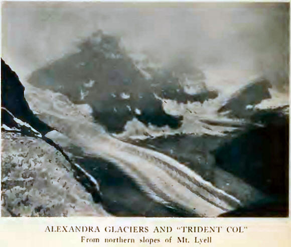
But weather was ever
unkind. We visited the glaciers, scarcely half a mile distant; enormous,
with flat tongues spreading below broken seracs so placed that one can
only with difficulty reach the upper snows. The western Alexandra
Glacier is conspicuous with its regular, parabolic dirt-bands,
differentiating the seasonal variation between winter and summer snows.4
On our first walk over the ice, a little shower passed, followed by an
entrancing double rainbow which arched from the ice-tongue to our camp
in the woods below.
Next day the peaks were
again shrouded in mist. It was July 4th, and we ascended, in three
hours, into the northern Lyell basin. Crevasses and the icefall of the
eastern Alexandra Glacier soon forced us to the moraine, a direct ascent
to which is made unpleasant by muddy cliff and running water. By a
little fire, kindled on an upper meadow, we sat and watched for
momentary glimpses into the upper ice-world as the snow-tops played
hide-and-seek in the fog. So many times from the viewpoints above Lake
Louise we had seen the triple-headed snow-mountain clear, against an
azure northern background; now to be on its very slopes and find it
hidden. Still it was not an unpleasant place to be, there beside our
smouldering fire. Although the heights were often invisible, we could
always gaze downward on those marvelous glaciers. The masses of ice were
softened here and there by the interposition of thin vapors, drifting
back and forth; towers and pinnacles of ice seemed on the verge of
splitting and crumbling; sea-green arches, transparent as our
finger-tips seem when held before a strong light, were all luminous with
the pale yellow glow that came through a distant snow-saddle beyond Rice
Glacier. Then, as we descended, rain drenched us. But a roaring fire at
camp, and a bit of bear-steak that Simpson brought in—I think he said he
found it growing on a tree—made us quickly forget the weather.
A few days later we
rode to Thompson Pass. It had cleared off, and we followed the trail up
Castleguard River—the name given to the stream above the Alexandra
angle—and through dense forest to the broad grassy levels leading to the
summit lakes. Watchman Peak is charmingly reflected in the lower lake,
while from the pass summit, below Spring Rice, we could look far into
the gloomy depths of Bush Valley with the unbroken wall of Mount Bryce
descending into it. This western country is wild in its appearance and
looks nearly impossible for horses.
It must have been about
this time that Jim, apropos of nothing in particular, remarked that his
birthday was about to recur. Tommy and I made secret plans. When the day
arrived, Tommy concocted a gigantic doughnut, liberally powdered with
sugar and mounted on a pedestal of heather. We stood the candle from our
folding-lantern in the centre and the result was almost artistic. At
lunch-time it was brought in with all ceremony and presented to “Chief
Nashan”—for Jim is known as the Wolverene among the Stoney Indians,
because of his uncanny ability as a hunter. Jim was much surprised; but
we were still more so, when he confessed that although the date was
right he had been a whole month short on time! Still we had had our fun
and the monotony of a day of showers was broken. After all, time on the
trail is an impossible thing to keep track of. |


