|
“The first travellers
called them the Glittering Mountains, on account of the infinite number
of immense rock crystals, which, they say, cover their surface, and
which, when they are not covered with snow, or in bare places,
reflect to an
immense distance the rays of the sun. The name Rocky Mountains was given
them, probably by later travellers, in consequence of the enormous
isolated rocks which they offer here and there to view.”
Gabriel Franchere
“The more elevated
portions are covered with perpetual snow, which contributes to give them
a luminous, and, at a great distance, even a brilliant appearance;
whence they derived, among some of the first discoverers, the name of
Shining mountains.”
Washington Irving
PREFACE
There is told, in the
Northwest, the story of an old prospector of whom, returning home after
many years, it was asked what he had to show as the equivalent of so
much lost time; and he answered only, “I have seen the Rocky Mountains.”
The desire to venture forth to the strange places of the earth is inborn
in most of us and we can quite understand the reply. Yet time and
opportunity seldom permit us to wander far from the beaten track.
Modern travellers,
however, due to increased transportation facilities, are at a distinct
advantage in comparison with the wanderers of a century ago, whose
journeys were made under conditions of great difficulty. Even fifty
years ago people were not found in the Rocky Mountains on pleasure bent.
In the opening of land areas, mountain ranges are things to be passed by
in the way most accessible; and not until a population becomes well
established does it begin to acquire the aesthetic sensibility which
enables it to devote a portion of its energy to the search after natural
beauty. This has been true of all highland countries—the Alps, the
Andes, the Himalaya, and the Rockies.
Thus, although travel
across the Rocky Mountains of Canada began more than a century and a
half ago, and the early fur-traders had considerable knowledge of the
passes and river routes, description of the upland valleys, the great
blue lakes, the vast icefields, has been reserved for wanderers of the
last three decades.
The Canadian portion of
the Rockies extends from the United States boundary at the 49th parallel
of Latitude, near the margins of Glacier National Park, to a point near
Latitude 54° where the 120th parallel of Longitude is crossed and the
range becomes sub-alpine. For more than four hundred miles it stretches
—a chain longer and less broken than the Continental Alps—and, in its
primeval state, who in a life-time can know it all?
Yet today many of us do
know something of it. For the tourist, passing through by rail, there
are splendid glimpses into the mountain land of Canada. Its margins are
accessible to everyone. Thousands of visitors have been to Emerald Lake
and the Yoho Valley; to Lake Louise and the Valley of the Ten Peaks; to
Banff and its delightful environs; and hosts of travellers, on a more
northerly route, are becoming acquainted with the vast wonderland of
Jasper Park. Engineers, however, being for the most part unimaginative
as far as scenery is concerned, put railroads through by the lowest and
easiest passes: natural beauty is incidental.
Hence it is that the
main chain of the Continental Divide, practically uncrossed by low
passes between the Canadian Pacific and the Canadian National Railroads,
is a land never seen by the casual tourist. It is true that the Howse
Pass and the Athabaska Pass were frequented in the days when the
fur-trade flourished, and were later thought of as suitable for rail
transportation routes; but, with the present locating of the roads,
these pass areas have returned to the oblivion of more than a century
ago.
Yet not quite. Alpine
wanderers, few in number to be sure, have come with their pack-trains,
have lingered a little while, and returned to tell of the marvelous
grandeur of new horizons. A few have told their story well. Others, due
to hardship and shortage of provisions, have come back with their goal
just beyond a bend. So if one be asked to compare the Rockies of Canada
with some other range, such as the Alps, it can only be said that we
know too little of them as a whole to place them fairly in apposition
with other mountainous regions.
If one realizes that
the things which characterize alpine areas are often found below the
snow-line, comparisons are not so difficult. In the Rockies of Canada
one seeks in vain for cattle herds, chalets, or funiculars; and in their
stead are found the pack-train, a bed of pine-boughs under an open sky,
and old trails of the Indians. And so this book is written to tell you
of the things beyond the margins; of natural wonders which will be the
heritage of coming generations. In the light of more accurate
topographical knowledge and established nomenclature, it seems not out
of place that a new volume should be added to the small list dealing
with mountaineering and exploration in the Canadian Rockies.
The author, with but
few intermissions during the past decade, has been actively interested
in the peaks and icefields at the sources of the Saskatchewan and
Athabaska Rivers. It is his desire to place on record the results of
three major expeditions into the mountain area of the Continental Divide
between the Canadian Pacific and the Canadian National Railroads,
together with less strenuous excursions among some of the beauty spots
which every trans-Canadian traveller should see. In this way it is hoped
that a volume will have been produced alike of interest to the leisurely
excursionist and to the more strenuous climber of peaks.
The Expeditions of 1922
and 1923 were undertaken for the purpose of investigating the icefields
and peaks at the headwaters of the North Saskatchewan River.
In 1922 the Freshfield
Icefield was visited and its highest peak, Mount Barnard, with a number
of others, ascended for the first time. A preliminary study of the
motion in the Freshfield Glacier was undertaken at this time. During
this season the upper Blaeberry, Howse, Mistaya, and upper Bow Valleys
were traversed.
In 1923 the author
visited the remaining icefield sources of the North Saskatchewan along
the Continental Divide. Alexandra River, the old “West Branch,” was
followed to its sources, and a base camp made on the margin of the great
Columbia Icefield, Canada’s tri-oceanic divide. The mountaineering
results were of importance and extensive data regarding the details of
the icefield were secured. The icefield was twice crossed, from
Saskatchewan to Athabaska sources. First-ascents were obtained of
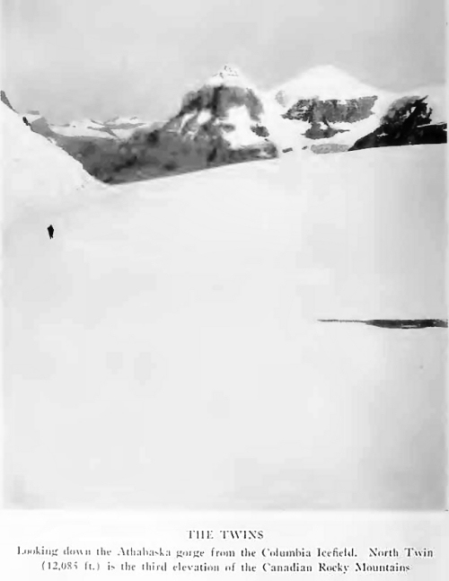
formidable Mount Saskatchewan, and of North Twin; the latter, 12,085
feet in elevation, being the third of triangulated heights in the
Canadian Rocky Mountains. Mount Columbia, 12,294 feet, the second
elevation of the range, was climbed for the second time. With horses a
remarkable crossing was made, by way of the Saskatchewan Glacier, from
the head of the “West Branch” to the sources of the Sunwapta; and, from
below Wilcox Pass, Mount Athabaska was ascended.
The Expedition of 1924
deals with a more northerly section of the Continental Divide, situated
at Athabaska River sources—the historic location of the earliest
mountaineering in Canada. The narrative extends to the Mount Robson
area, where the author had previously camped in years before the
appearance of the “modern conveniences” that now exist.
This then is a book of
mountaineering, not presenting the Canadian Rockies in their entirety—no
single volume will ever do that—but including many of the finest things.
It is also a book of mountain travel, under conditions such as perhaps
the European traveller experienced in the Alps during the Eighteenth
Century. Finally it is a book of mountain history; for here is Geography
in the making, and with a tradition behind it—a story that has never
been properly gathered together, and whose details, in part at least,
are gone forever.
While our own
performances have been thought worthy of the printed page, they can
never mean to the reader quite what they mean to those who took part in
them. You must go yourself to comprehend the daft enthusiasm which
follows such a journey. No one but ourselves can ever be identified with
those days of crag and precipice; of ice and snow in sunshine and storm;
those days with the pack-train winding along northern trails; those
nights—starlit nights in the country of fur-trade routes—with song and
story beside the campfire. Those things are ours forever, while life
lasts. Our guide, Conrad, and he is a philosopher, used to say, “It is
good to have been once young, if only you have happy memories.” A modern
writer has paraphrased the thought in saying, “Memories are given us
that we may have roses in December.”
This is the record of
our mountain memories, which may perhaps have the power of shedding
afterglow, even though the light be dim in comparison to realities. And
yet, if you glimpse but a bit of it, great indeed will be our reward.
A great deal of
painstaking research was required in collecting the early historical
material for the present volume, but as far as possible every
source-book has been examined. The old narratives are exceedingly rare,
and not to be had in every library. For this reason they have been more
fully quoted than otherwise, in order that they may afford an available
authentic record of events occurring within the mountain area before the
advent of modern travellers.
A certain amount of
topographical material has been inserted, and those who care to follow
it in detail should secure the Atlas of the Alberta and British Columbia
Boundary, Part II, containing maps which will be of service. The Atlas
may be obtained from the Topographical Survey of Canada, Department of
the Interior, Ottawa.
Not all that follows
makes its appearance for the first time;1 but the outlines of several
chapters, pub-ished in the Alpine Journal, the Bulletin of the
Geographical Society of Philadelphia, the Canadian Alpine Journal, and
elsewhere, have been largely rewritten, amplified, and moulded to
conform to a progressing narrative.
Acknowledgement is due
to the many who, by their favors and suggestions, have made this book
possible. The Topographical Survey of Canada, comprising a group of
gentlemen most cordial, has allowed the use of a selection of
photographs obtained during the fieldwork of the Interprovincial
Boundary Commission. The Smithsonian Institution has agreed to the
reprinting of Mr. Palmer’s paper on the Freshfield Glacier. Messrs.
Osgood Field, Val. A. Fynn, Wm. S. Ladd, Howard Palmer, Harry Pollard
and Max Strumia have permitted the use of photographs. Dr. James A.
Morgan, of Honolulu, has kindly secured for me a photograph of Douglas’
Tombstone. The editors of the Alpine Journal, Appalachia, and the
Canadian Alpine Journal have loaned a number of the engraved blocks.
During 1922 and 1923,
the pack-trains were in charge of James Simpson, a pioneer and hunter of
wide experience, a powerful mountaineer, a man of resource and
initiative, and withal, a true friend; to whom, in company with Conrad
Kain and Edward Feuz—the leaders of the mountaineering—the author has
taken pleasure in dedicating this book.
J. M. T.
2031 Chestnut Street Philadelphia, Pa. December, 1925
CONTENTS
Chapter I. Lake Louise:
The Entrance to the Northland.
Chapter II. Trails of the Waputik.
Chapter III. The Freshfield Group.
Chapter IV. The Mountains of the Alexandra Angle.
Chapter V. The Ascent of North Twin.
Chapter VI. Mount Saskatchewan and Mount Columbia.
Chapter VII. Passage of the Saskatchewan Glacier.
Chapter VIII. Athabaska Pass and the Voyageurs, 1811-1827.
Chapter IX. Athabaska Pass and the Voyageurs, 1846-1872.
Chapter X. Nineteenth Century Speculation in Regard to Altitude at Athabaska Pass.
Chapter XI. The Mountains of the Whirlpool.
Chapter XII. Climbs from the Scott Glacier.
Chapter XIII. The Ramparts and Mount Fraser.
Chapter XIV. In the Shadow of Mount Robson.
Chapter XV. Trail’s End.
Appendix A. Summary of Ascents, Between Kicking Horse and Robson Passes,
1922-24.
Appendix B. Summarized Itinerary of Expeditions, 1922-24.
Appendix C. A List of Some of the Loftiest Triangulated Peaks of the
Rocky Mountains of Canada.
Appendix D. The Freshfield Glacier, Canadian Rockies (by How and
Palmer).
Appendix E. David Thompson and the First Crossing of Howse Pass.
Appendix F. The Panorama from Mount Columbia.
Appendix G. A Note on the Original Journals of David Douglas. |


