|
“Our course lay, for
the most part, over vast fields of snow, but the early portion of it
presented scenery of surpassing beauty, far more magnificent and
dazzling than that of the day before. There were broad and bridgeless
chasms, whose depths the eye, from their dizzy edges, vainly sought to
ascertain;—towering masses, in forms that, from their strangeness,
seemed unreal;—spires of brightness, grottos and palaces of frost,—here
recent, soft, of snowy whiteness,—there older, hardened, passing into
crystal azure,—sprinkled with frozen dew, festooned with silver fringe;
their inmost caverns dark,—vast stalactites of ice, in line, guarding
the portals.”
Dr. Martin Barry
The Continent of North
America possesses two hydrographic apices which are remarkable for the
river systems extending therefrom. In each of these areas occurs a
watershed of the triple-divide type whose streams form great and lengthy
rivers, flowing enormous distances to terminate in widely separated
bodies of water.
The southerly of these
interesting regions is found, near Latitude 43°, in the Wind River
Mountains of Wyoming, south of Yellowstone National Park. Here rises the
Snake River, flowing to the Columbia, its waters carried through British
Columbia and emptying into the Pacific at the northwest corner of
Oregon. Not many miles distant are sources of Green River, flowing
southwest to the Colorado and reaching the Gulf of California. Eastward,
branching headwaters of the Missouri find their way to the Mississippi
basin and the far-off Gulf of Mexico.
Less well known is the
Canadian watershed to be found in Latitude 52°. There, in a region
extensively glaciated, are sources of river systems whose waters make
their way for hundreds of miles, by winding, devious routes to three
separate oceans.
The Rocky Mountains of
Canada form the Alberta-British Columbia Boundary and extend northward,
from the Montana line, at the 114th Parallel, until the 120th Parallel
is reached, near Latitude 54°, and
the range becomes
subalpine. Great icefields mantle the Continental Divide between the
Canadian Pacific and the Canadian National Railroads, the scenic
grandeur culminating in the Columbia Icefield, in Latitude 52° 12'.
This icefield, the
largest known in Canada, containing approximately one hundred and fifty
square miles, forms an unusually compact triple-divide. From its snows,
on the Continental Divide, attaining an elevation of 10,000 feet over a
large area, are formed the headwaters of the Athabaska, which, by way of
Great Slave Lake, joins the Mackenzie system whose delta is beyond the
Arctic Circle. Western ice-tongues supply Bush River, tributary to the
Columbia and reaching the Pacific. From many converging streams on the
eastern slope is formed the Saskatchewan River, emptying into Lake
Winnipeg whence the Nelson River continues the drainage to Hudson Bay
and the North Atlantic.
Thus do two mountain
uplifts form the drainage sources for much of Continental America
between Mexico and Alaska.
The two water-partings
possess no little of historic interest. In 1805, the Lewis and Clark
Expedition, reaching the forks of the Missouri, pioneered the Jefferson
River and crossed to the Clearwater branch of the Columbia on their way
to the Pacific Coast. Only a little later, Canadian fur-traders, in
1807, made use of the Howse Pass in travelling across the Rocky
Mountains, from the North Saskatchewan—the Kootenay Plain—to the
Columbia Valley. In 1811, the Athabaska Pass was opened by David
Thompson of the North-West Company and served for many years as a
much-frequented route between Athabaska trading posts—Fort Edmonton,
Henry House, and Jasper House—and the Columbia Loop.
Anyone who has even
superficially examined the map of a Continent, will realize that rivers
of any length possess sources in elevated portions of the earth’s
surface. It is the land uplift, usually a mountain region, in which
occurs the greatest precipitation; the ranges and inland table-lands, or
even lofty plateaus, serve the further purpose of providing the
potential energy, the vis a tergo, for stream flow. It will be further
understood that such a region is topographically more complex than an
area of coastal plain; and that, to unravel the complex features which a
mountain range often possesses and which are frequently hidden, it is
quite essential for a field observer to attain lofty ridges—if not the
very summits themselves—in order to discover what may lie beyond.
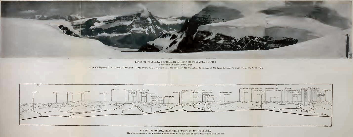
The Columbia Icefield,
one of the largest subarctic fields, was first seen, in 1898, by J.
Norman Collie,1 who described the view from the
summit of Mount Athabaska, as follows: “A new world was spread at our
feet; to the westward stretched a vast ice-field probably never before
seen by human eye, and surrounded by entirely unknown, unnamed, and
unclimbed peaks. From its vast expanse of snows the Saskatchewan Glacier
takes its rise, and it also supplies the head-waters of the Athabaska;
while far away to the west, bending over in those unknown valleys
glowing with the evening light, the level snows stretched, finally to
melt and flow down more than one channel into the Columbia River, and
thence to the Pacific Ocean. Beyond the Saskatchewan Glacier to the
south-east, a high peak (which we have named Mt. Saskatchewan) lay
between this glacier and the west branch of the North Fork, flat-topped
and covered with snow, on its eastern face a precipitous wall of rock.
Mount Lyell and Mount Forbes could be seen far off in the haze. But it
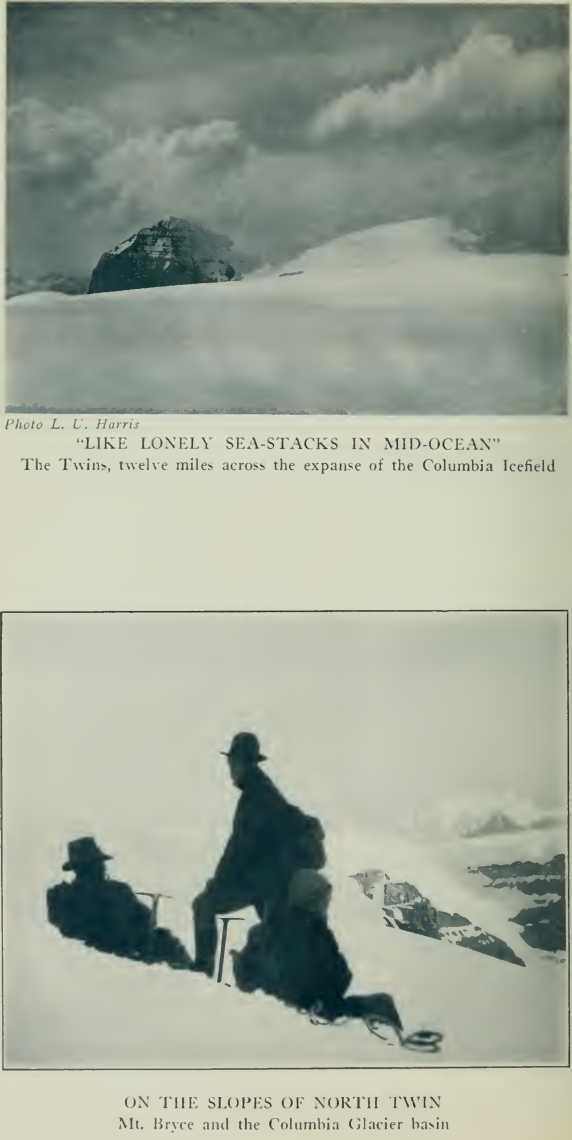
was towards the west and north-west that the chief interest lay. From
this great snow-field rose solemnly, like ‘lonely sea-stacks in
mid-ocean/ two magnificent peaks, which we imagined to be 13,000 or
14,000 feet high, keeping guard over those unknown western fields of
ice. One of these, which reminded us of the Finsteraarhorn, we have
ventured to name after the Right Hon. James Bryce, the then President of
the Alpine Club. A little to the north of this peak, and directly to the
westward of Peak Athabasca, rose probably the highest summit in this
region of the Rocky Mountains. Chiselshaped at its head, covered with
glaciers and snow, it also stood alone, and I at once recognised the
great peak I was in search of; moreover, a short distance to the
north-east of this mountain, another, almost as high, also flat-topped,
but ringed round with sheer precipices, reared its head into the sky
above all its fellows. At once I concluded that these might be the two
lost mountains, Brown and Hooker.”
The high rock-peak,
which Collie thought might be Mount Brown, was later named Mount
Alberta, while the glacier-clad mountain was christened Columbia. Two
fine peaks, one rocky, the other snow-covered, which from the level of
the icefield hide Alberta, became known as The Twins.
From Thompson Pass, the
Continental Divide swings northward across the eastern shoulder of Bryce
(11,507 feet), and, traversing the centre of the icefield, rises to the
summit of The Snow Dome (11,340 feet), the hydrographic apex of the
Saskatchewan, Athabaska, and Columbia River systems. Almost doubling on
itself, the Divide then turns sharply southward and westward to the
summit of Mount Columbia.
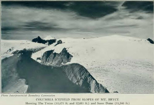
This splendid peak,
attaining the elevation of 12,294 feet, according to measurements of the
Interprovincial Survey, is the second peak of the Canadian Rockies and
is overtopped only by Mount Robson (12,972 feet), the highest of the
entire range. Robson is situated on the Continental Divide, there a
Pacific-Arctic watershed, north of Yellowhead Pass; but it rises from no
icefield comparable to the Columbia.
North Twin, a near
neighbor of Columbia, reaches the height of 12,085 feet, making it the
third elevation of the range and the loftiest summit entirely in
Alberta.
From Mount Columbia,
the Divide crosses Mount King Edward (11,400 feet), and Chaba Peak
(10,540 feet), and peaks along the crest of the Chaba basin, gradually
descending to Fortress Lake Pass (4388 feet).
In the deep valley
north of Mount Bryce, and below Columbia, three crevassed glacier
tongues supply Bryce Creek, which joins with Rice Brook from
Thompson Pass and the
glaciers west of Mount Alexandra to form the North Fork of Bush River
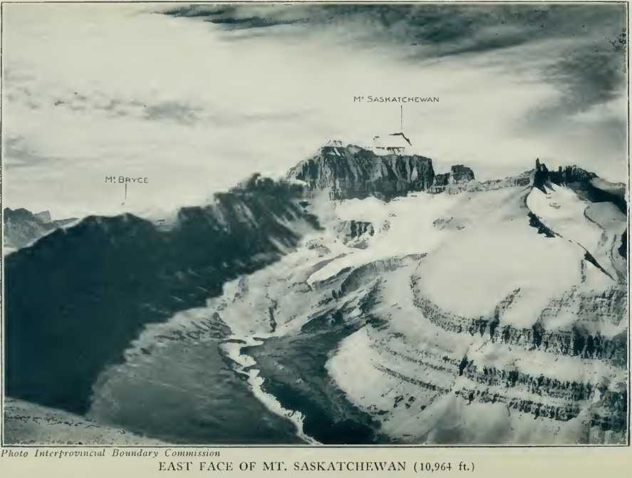
and drain to the Columbia Valley. From Mount Castleguard (10,096 feet),
the Castleguard Glacier tongues form northern sources of Alexandra
River, while to the east of Castleguard Valley minor, separate
snowfields supply Castelets and Terrace Creeks. Above Terrace Valley
rise the shattered, forbidding cliffs of Mount Saskatchewan (10,964
feet), filling in the angle between Alexandra River and the North Fork.
The northern margin of
the Columbia Icefield is bordered by the broad snows of Mount Kitchener
(11,500 feet), and The Twins—South Twin, 11,675 feet; North Twin, 12,085
feet—the latter, as we have seen, the third of triangulated peaks in the
Canadian Rockies. Between The Twins and Mount Columbia a magnificent
precipitous cirque contains the plunging, banded Columbia Glacier and
the tongue from The Twins, draining to the main Athabaska River. The
Twins and Mount Kitchener, grouped with peaks farther north—Stutfield
(11,320 feet), Woolley (11,700 feet), Diadem (11,060 feet), and
Alberta—make up the gigantic massif, as yet but partially mapped,
between the Sunwapta and Athabaska Rivers.
To see these things we
had come up-trail, past Outranks old “Camp Columbia,” with its
surprising waterfall, to campground above 7000 feet in the meadows below
Mount Castleguard and its ice-tongues. Here, indeed, is the spot of
which wranglers dream: plenty of water, wood everywhere, horse-feed for
months; and the horses can’t get away! Castleguard Camp fulfills one’s
idea of Alpine Paradise. A meadow, acres of it,
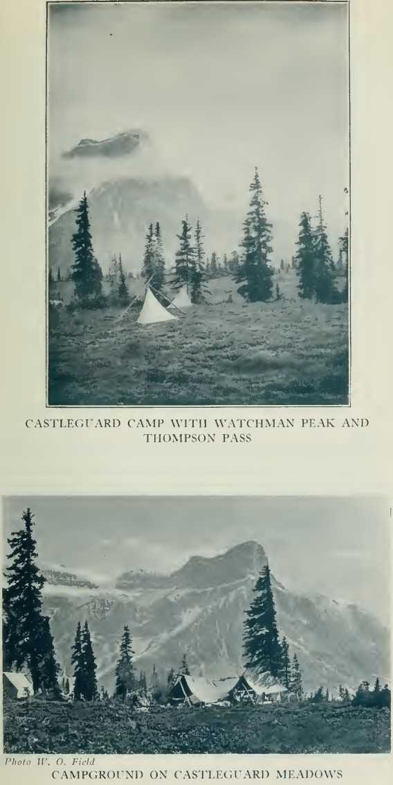
with a heather carpet
and flowers beyond description; little cascading streams; a tiny canyon,
where leaps an arching waterfall. Can you imagine it at evening? Smoke
from the campfire rising through tall trees beside the tents;
horse-bells tinkling in the distance, as they might on a foreign alpland;
snow summits of Lyell turning heliotrope and violet; shadowed walls of
Castleguard Valley seen to the Bend; Watchman Peak, with Thompson Pass
patched by sunlight, and glimpses of far-away ranges in the west; Mount
Bryce, stupendous, its icy peaks silhouetted and incandescent; the low
southern Castleguard tongue brilliant with light reflected from the
Columbia Icefield; Mount Castleguard itself, and Athabaska, at the
valley head, old-rose and golden. One despairs in the telling of it. It
is a place to which one will return.
From camp, one is but a
short distance from Thompson Pass. Two hours’ walk to the valley head
leads over a low divide to the Saskatchewan tongue, whence Mount
Athabaska could be climbed. East of camp, a range of minor peaks, of
which Terrace (9750 feet) is the chief, separates Castleguard from
Terrace Valley. It is easy to cross a low snow pass below the southern
slopes of Athabaska South station, and reach meadows below Mount
Saskatchewan. Finally, in two hours one may ascend the Castleguard
Glaciers to the eastern ridge of Mount Castleguard, at 9000 feet, whence
a route to the summit is obvious; or, what is of equal interest, one may
circle to the northwest and attain the Columbia neve without having
crossed a single crevasse of any size. As many of the icefield climbs
are of great length, the gaining of altitude and
the avoidance of
icefalls is an immense advantage over Outram’s route to Columbia by the
low southern Castleguard tongue or Collie’s attempted route through the
crevasses of the Athabaska Glacier.
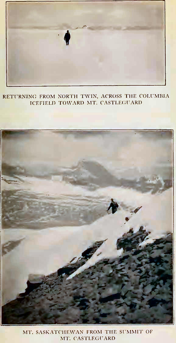
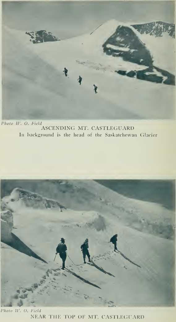
Mount Castleguard, of
which we made the first traverse, on July 6th, affords the finest near
views of the Columbia Icefield. Our entire party went up, including
Simpson, our cook, and our wrangler. Above the eastern ridge, which we
attained by way of the easy central glaciers, are short stretches of
steep snow. A little bergschrund is crossed and the summit reached in
four hours from camp. The mountain dominates Saskatchewan Glacier and
presents a splendid overlook across the icefield, which stretches
endlessly westward toward Mount Columbia and northward to The Twins.
Little misty clouds scud along in the breeze, their shadows wandering
out across the snow and separated by splotches of sunlight. Mount Bryce,
in its sheer grandeur, is nearby, with range after range beyond the
wooded depths of Bush Valley. Mount Forbes lifts a white fang in the
south, while nearer are the flanks of Lyell and Alexandra streaming with
glaciers.
Jim and Conrad are
lying flat on the shale, with a map spread out; there is a great
pointing of fingers toward distant valleys, and the remarks which come
to my ears indicate that fur-bearing animals next trapping season had
best look out for themselves. Ladd and Frog are dividing the last piece
of cheese, and Frog is not getting the best of it. Tommy and I sit with
our backs against the summit cairn; one corner of it is decked with a
mossy fringe of hoar-frost, which
is dripping in the
sunlight and falling into several cups to which we have constructed
elaborate aqueducts of flat stones.
Two hours on the summit
flew rapidly, and we descended the northern Castleguard snow-ridge in
spraying glissades to the icefield. Columbia seemed so near to us; it
was early in the afternoon and we walked some distance toward it before
turning homeward. It was a day of enjoyment for all, although the
momentary disappearance of Tommy through a snow-bridge was startling. We
were fond of our cook, and our morale in those strenuous days depended
much upon his oft-repeated bellow of “Come and get it.” Four meals in a
day never seemed too much!
Next morning a climbing
party of four again ascended to Castleguard shoulder, hoping to reach
Mount Columbia; but cold wind and snow-squalls prevailed, and drove us
ignominiously back to camp where we made short work of a fresh batch of
Tommy’s biscuits. Our labor was not entirely useless, for we packed up
to the ridge a supply of clothing, condensed fuel, and a small tent, to
serve as a high camp in emergency.
July 9th was a day of
threatening weather. Ladd went down-trail toward the Castleguard stream
and tried the fishing, but with indifferent success. Conrad and I made a
little first-ascent of Terrace Mountain (9750 feet), by its southern
glacier and the col at its head. The glacier is small, but offers an
array of wavy, wind-blown ridges of snow, in whose hollows we counted no
less than twelve lakelets, interconnected by ice-tunnels. The mountain,
situated between Castleguard and Terrace Valleys, is without difficulty,
three hours bringing us to the corniced summit, whence one obtains a
map-like view of the Columbia Icefield with its glacier-tongues
extending out, like tentacles of some monster of pre-history. Altogether
it is one of the most satisfactory views in the vicinity, and the
overlook to Mount Saskatchewan served us well a few days later.
To ascend the unclimbed
North Twin (12,085 feet), had been the great prospective of our journey.
On July 10th we attained this goal. With an early start (3.20 A. M.), in
two hours we were high on the Castleguard ridge and off on the margin of
the icefield. New snow had fallen during the days preceding; bands of
mist raised fingers, swirling skyward, as if to warm them in the glow of
morning. Columbia and The Twins, afar, showed only their upper heights
above the undulating snowy wastes.
We came to know the
Columbia Icefield on that day. It was six o’clock when we left the
ridge. Soft snow and distance: North Twin is twelve miles in air-line
from Castleguard shoulder, but looks less than half of that. One
descends, above the head of Saskatchewan Glacier, into a broad, nearly
level basin, whence the slopes rise gradually along the base of an
unnamed snow-crest adjoining Athabaska on the west. Just this much takes
hours; and, on rounding the head of Athabaska Glacier to the base of The
Snow Dome, one is but half way to North Twin.
The Snow Dome does not
rise conspicuously from the icefield; it is broad-based, situated west
of the Athabaska Glacier, and slopes gradually up to a summit slightly
more than a thousand feet above the main field. It is more attractive
when seen from Wilcox Pass, in which direction it presents gigantic
ice-crowned cliffs and terraces, with a spectacular icefall ending near
the Athabaska tongue. The chief interest of the mountain is in its
position as hydrographic apex of the region. From its slopes, melting
snow flows to the North Saskatchewan; to the Athabaska, through the
Sunwapta River; to the Columbia, by way of Bush River headwaters. These
rivers, flowing to three different oceans, spring from one of the
greatest of Continental watersheds.
As we skirted the
western slopes of The Snow Dome, North Twin loomed apparently close at
hand; but distances are as deceptive as on the ocean, and nearly level
snow hides many deep depressions. We circled widely to avoid crevasses
at the head of Columbia Glacier, which slopes to the Athabaska Valley.
The Twins are an isolated pair, ringed by cliff and icefall, North Twin
alone being connected with the icefield by a snow col—a ribbon of
snow—leading down toward Habel Creek. And after weary hours,2
when one has crossed the last long slopes and plateaus, it is necessary
to lose altitude in crossing this deep saddle to gain the peak.
Here we made the first
stop, for lunch, at two o’clock. Over the head-cirque of Columbia
Glacier rise Mounts Columbia and King Edward, above icy terraces and
benches of cliff. South Twin is close at hand, with grim, pinnacled
walls, towering to a sharp ice-peak, difficult in appearance, and only
to be attacked by the col connecting it with its northern relative.
Framed by North Twin and the snow-humps of Stutfield, the valley of
Habel Creek is a foreground for cliff-ringed and unclimbed Mount
Alberta.3
Our own peak,
immediately above us, its corniced summit ridge intermittently hidden by
snow-flurries and wind-blown mist, rose in a slope of glistening snow,
steep and unbroken. Conrad was leading, I was second, and Ladd last on
the rope. The wall of snow was ever before us as we went up; there was
considerable step-cutting, not in hard ice, but in crusted snow, and our
pace slowed before the top of King Edward came into view above the sharp
arete of South Twin. We reached the summit just thirteen hours after
leaving camp: fleeting glimpses of winding rivers in the west and of
shining summits in the direction of Maligne Lake and Wilcox Pass were
blotted out in the closing mist.
Still, it was warm
enough—just a moderate breeze blowing—and we remained twenty minutes on
the summit; but the view we hoped for never came. The descent to the col
was without incident (4.40-5.40 P. M.) ; we had made the first traverse
of the Columbia Icefield, from Castleguard Valley to the head of Habel
Creek—from the Saskatchewan to the Athabaska slope —and the last
untrodden twelve-thousand-foot peak of the Rocky Mountains of Canada had
fallen to us.
Someone, following in
our track, may one day understand that journey back across the
icefield’s vastness. For an analytical mind, it will at least afford
insight of the psychology of fatigue: the half-hour in a blizzard,
obscuring the trail and exhausting us; the clearing at sunset, with
crimson and orange light banded against masses of lead-blue storm clouds
behind The Twins; mist and snow-banners wreathed about and trailing from
Columbia and catching up the light —we three mortals in the middle of
the field, in all its immensity, struggling on in insufficiently crusted
snow until the light failed.
We had brought some
portable fuel and a small kettle with us and left it on a snowy hummock
far out on the icefield against our return. It was dark when we
approached it, but we soon had some water melted to slake a burning
thirst. While Conrad and Ladd were attempting to make tea, I walked on
alone to the slopes below Castleguard. The unbroken snow was hardening a
little, the air comfortably cool, and only a gentle wind stirring. I sat
down to wait for the others. Beyond Athabaska dark clouds hung and
lightning flashed; in another direction, above Mount
Bryce, stars appeared
in all the glory of high altitudes; in the western horizon there was
still a pale afterglow, and bits of mist floated about on the surface of
the icefield, as if earth and sky were mingled in one.
The rest of the party
came up; I had seen the flickering lantern, and located them by their
shouts. We roped up together and went on through the night, over the
Castleguard shoulder and down the long slopes beyond. It is not easy to
thread crevasses in the dark—lucky that we knew the way, but how we
cursed that lantern! When we pulled into camp, it was three o’clock, and
morning was on the hills as it had been when we departed.
Twenty-three hours we
had been out; we were very tired, and the grass beside the campfire
seemed luxurious in its softness as we sat there breakfasting in the
light of the rising sun.
|