|
(The Ascents of Mounts
Kane and Brown)
“Geography is an art
as well as a science. And in parenthesis I may say that I doubt whether
any science is complete which has not art behind it. We shall never be
able fully to know and understand the Earth or to describe what we see
if we use our intellectual and reasoning powers alone. If we are to
attain to a complete knowledge of the Earth, and if we are to describe
what we learn about it in an adequate manner so that others may
participate in our knowledge, then we must use our hearts as well as our
heads. We must be artists as well as meticulous classifiers, cataloguers
and reasoners.
“And, therefore, I
hold that if the function of Geography is to know the Earth and to
describe the Earth, then the objection that the description of its
Natural Beauty is outside the scope of Geography is not a valid
objection. The picture and the poem are as legitimate a part of
Geography as the map.,}
Sir Francis
Younghusband
Twenty years ago, with
an objective group of peaks several hundred miles distant by trail, a
journey to a remote district was not to be lightly undertaken. The early
days of mountaineering in the Canadian Rockies began when there was as
yet no railroad through Yellowstone Pass. Consequently, most
expeditions, at that time—even when bound for the far north—started from
points on the Canadian Pacific Railroad, Banff or Lake Louise.
A. P. Coleman1 and his
companions are responsible for the early enthusiasm, resulting in the
repeated searches for the mysterious high peaks of Athabaska Pass. In
1888, they attempted to enter the region by way of the Columbia Loop,
and actually reached Kin-basket Lake before abandoning the enterprise.
In 1892, a second attempt, by way of North Saskatchewan and Athabaska
headwaters, led them to Fortress Lake —which but for the absence of
Mounts Hooker and Brown, and the discrepancy in the size of the lake,
might have been the Committee Punch Bowl.
In 1893, a third
expedition, led by Coleman, successfully reached the Athabaska Pass. The
highest mountain on the western side of the pass was ascended, and was
considered to be the peak which Douglas climbed.
They also ascended
M’Gillivray’s Rock, the point where Mount Hooker is indicated on the
Palliser map, but noted that “a much higher, finer peak rises a few
miles east of the Punch Bowl, with fields of snow and a large glacier,
and was estimated at about eleven thousand feet.” Because of the small
size of the Committee Punch Bowl, a folding canvas boat, intended for
use on the lake, remained in its pack-cover.
None of the other early
expeditions actually reached Athabaska Pass, although the search for the
high peaks was by no means given up. Wilcox and Barrett in 1896 reached
Fortress Lake. Wilcox triangulated the massive glacier-bearing peak to
the west—the present Mount Serenity—at 10,500 feet.
Habel, the German
explorer, in 1901, spent several days near the lake and mentions
Serenity as “a very prominent snowy mountain, visible nearly from top to
bottom, in shape similar to Mont Blanc.”
Collie, who came out
from England first in 1897, became interested in the Brown-Hooker
problem. In those days, knowledge of the topography was so imperfect
that it was thought that the North Fork of the Saskatchewan had its
source in the neighbourhood of Athabaska Pass. Collie had seen high
peaks in the north, from the slopes of Mount Freshfield, and, in 1898,
visited many of them by way of the North Saskatchewan. The Athabaska
Pass was not reached, but the climbers had their reward in the discovery
of the huge Columbia Icefield.
Following the visit of
Coleman, the next attempt at mountaineering from the pass was made, in
1913, by Messrs. Howard and Mumm,3 of the Alpine Club, accompanied by
the guide Moritz Inderbinen. On the way in from Jasper, minor summits
were attained; but in the immediate vicinity of Athabaska Pass the
weather became so unfavourable that little could be done. Mumm and
Inderbinen ascended Mount Brown and later visited the great glacier—the
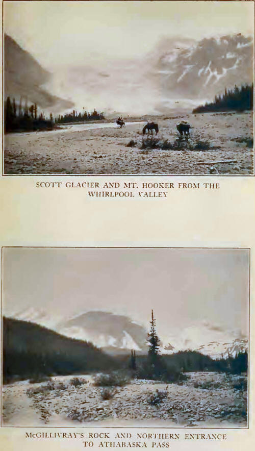
present Scott Glacier—at the source of Whirlpool River.
The first ascent of
importance in the Whirlpool Group was that of Mount Serenity, made from
Fortress Lake, in 1920, by Messrs. Carpe, Palmer and Harris. The route
to the summit, by way of the Serenity Glacier and the southern arete,
required ten hours from a camp at the glacier tongue.
In 1920, the
Interprovincial Survey visited the Athabaska Pass and established the
present nomenclature. A large number of stations were occupied,
including Mount Brown, McGillivray Ridge (Mount Brown E.), Alnus and
Divergence Peaks.
The Survey Commission4
published the following conclusions in regard to the Hooker-Brown
problem:
“Mt. Brown. The
mountain ascended by Douglas and named Mt. Brown by him is the one
rising directly on the west side of the pass summit, the altitude being
9156 feet, 3405 feet above the pass.
“Mt. Hooker. The
location is not so clear. Douglas writes in his journal, (1) ‘A little
more to the south is one nearly the same height, rising more into a
sharp point which I named Mt. Hooker.’ (2) ‘I set out with a view of
ascending what appeared to be the highest peak on the north or left-hand
side.’ Against these statements is the fact that the direction of the
valley at the summit of the pass is practically north and south and
consequently Douglas’ ‘north or left-hand side’ would truly be ‘west or
left-hand side;’ so also with reference to Mt. Hooker, ‘a little to the
south is one nearly the same height’ would truly be ‘a little to the
east is one nearly the same height.’ Douglas’ idea of his direction
seems to have been as inaccurate as his idea of altitude. On a bearing
18° north of east lies a peak, rising into a sharp point,
Mr. Cautley describes,
among other things, the discovery, just north of the pass summit, of the
musket-balls lost by David Thompson a hundred and ten years before. (See
Chapter VIII, p. 111.) which is distant approximately six miles from the
summit of Mt. Brown and which has an altitude of 10,782 feet, or 1626
feet more than that of Mt. Brown. It seems more likely that this is the
mountain Douglas refers to as Hooker. (This is the mountain seen by
Coleman and Stewart, and estimated at 11,000 feet.)
“From the vicinity of
Fortress Lake this mountain peak stands up in a sharp white cone. It is
not conceivable that the long, evenly crested ridge (i. e., Mc-Gillivray’s
Rock) rising directly above the Punch Bowl from Athabaska Pass summit
has anything to do with the question. It was, therefore, recommended to
the Geographic Board that the 10,782 foot peak about six miles easterly
from Mt. Brown be confirmed as Mt. Hooker, which has been done.” Thus
rests the question officially.
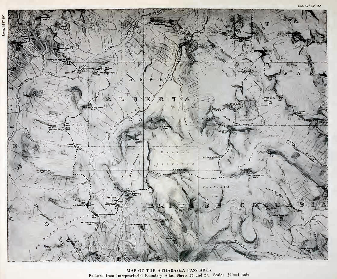
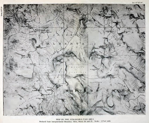
For a moment let us
consider the modern topography of the mountains south of Jasper. The
Whirlpool Group occupies the rough triangle enclosed between the
Whirlpool and Athabaska Rivers on west and east, and by Fortress Lake
and Wood River on the south. It includes the portion of the Continental
Divide between Fortress and Athabaska Passes, an airline distance of
twenty miles, and its continuation to Whirlpool Pass. The air-line
distance between Athabaska and Whirlpool Passes is eight miles.
The northern tip of the
group, in the angle of the Whirlpool-Athabaska junction, although
visible and but a day’s trail-riding from Jasper, has yet to be mapped.
In this angle is a striking peak, known by local name as “Whirlpool
Mountain,” south of which, with its upper crags visible from Jasper
above the eastern shoulder of Mount Edith Cavell, is Mount Fryatt
(11,026 feet), one of the outstanding mountains of the Park. Other peaks
east of the Divide, included in the mapped area, are Lapensee (10,190
feet), and Belanger (10,200 feet), just south of Fryatt; while farther
east, Mount Christie (10,160 feet), and Brussels Peak (10,370 feet),
culminate a sub-group toward the Athabaska. Only a few miles north of
Fortress Mountain, Mount Catacombs, attaining 10,800 feet, is the chief
peak in the southeastern section.
From Fortress Pass
(4388 feet), and Fortress Mountain (9908 feet), the Divide westward
includes no peaks of importance as far as the head of Alnus Creek. At
the western end of Fortress Lake, Alnus Valley enters Wood River at an
acute angle from the northwest. At the head of Alnus Creek, low passes
lead over to Divergence Creek, a Whirlpool tributary, and form a major
trench extending through the Whirlpool Group.
It is chiefly with the
area west of Alnus and Divergence Valleys that mountaineering interests
have been concerned, as this portion of the group contains important
peaks and many of the finest scenic features.
At the head of Alnus
Creek, on the Divide, is Divergence Peak (9275 feet), whence the
watershed swings sharply southward, crossing the summits of Alnus (9673
feet), Ross Cox (9840 feet), Scott (10,826 feet), Oates (10,220 feet),
and Ermatinger (10,080 feet) The watershed now swings abruptly westward,
crossing Mount Hooker (10,782 feet), and, route from the Whirlpool to
Wood River, and we noticed tracks, high on the snow, on several
occasions.
The air-line distance
between Divergence Peak at the head of Alnus Creek, and the Committee
Punch Bowl on Athabaska Pass, is twelve miles. On the Pass summit (5736
feet), are the Punch Bowl and two other adjacent lakelets, giving rise
to terminal sources of the Whirlpool River, on the east, and Wood River,
through Pacific Creek, on the west.
The Continental Divide
continues from the Pass, rising westward to the summit of Mount Brown
(9156 feet), thence turning northward and dropping to the icy lakes at
the head of Robert Creek, and to Canoe Pass (6772 feet), connecting
Whirlpool River with a branch of Canoe River. Crossing Mallard Mountain
(9330 feet), the Divide reaches Whirlpool Pass (5936 feet), linking the
Middle Whirlpool with the Mazama Creek branch of Canoe River. It will
thus be seen that there are no peaks of importance immediately west of
Athabaska Pass and the Whirlpool; the Divide is relatively low and can
be crossed at several points. The feature of interest is the large area
of glacier and snowfield on the southwest side of Mount Brown, extending
into the angle between Wood and Canoe Rivers. The Continental Divide
bends considerably in rounding the head of Whirlpool River, consequently
the air-line distance between Divergence Peak and Whirlpool Pass is only
about eight miles, practically equal to the distance between Athabaska
and Whirlpool Passes.
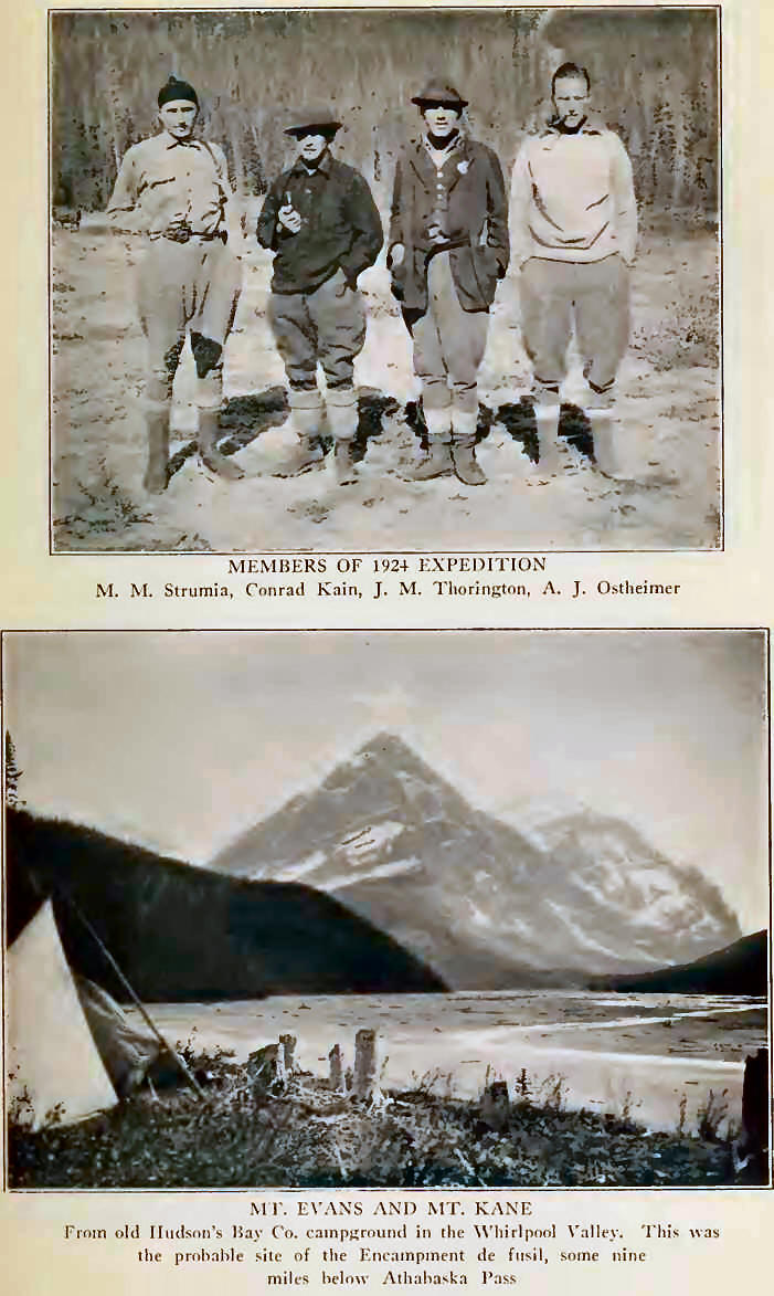
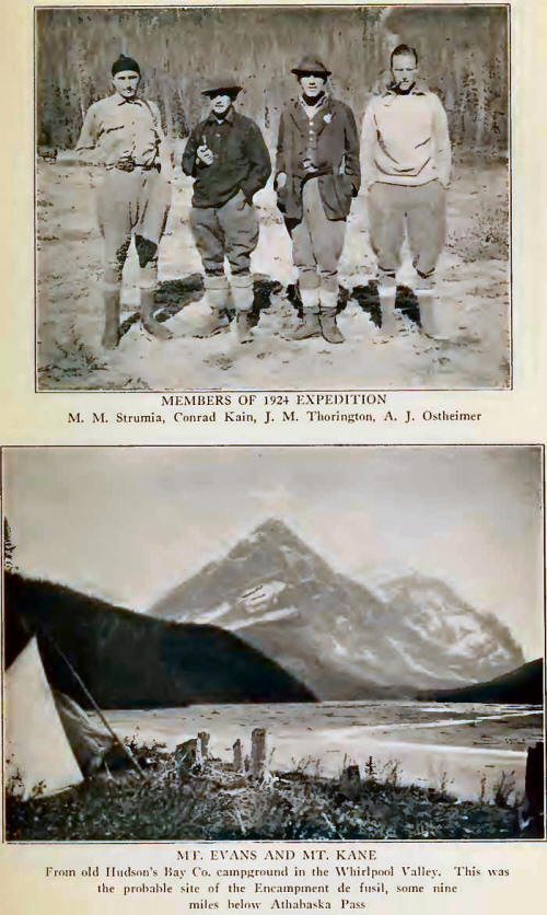
The author’s
expedition, in 1924, was the third to reach the Athabaska Pass for
purely mountaineering purposes. Fortunate were we in coming to a place
so little known—new peaks were everywhere at hand. Within a short space
of time we were able to make the first-ascent of Mount Hooker and other
peaks of the vicinity, and to explore the intricacies of the Kane and
Hooker Icefields, as well as a portion of the vast topography of the
Mountains of the Whirlpool.
From the Canadian
National Railroad, with fourteen horses furnished by the well-known
outfitter Donald Phillips, our party, including Mr. Alfred J. Ostheimer
and Dr. Max Strumia of Philadelphia, myself, and the guide Conrad Kain,
left Jasper on June 26th, bound for Athabaska Pass. In charge of the
horses came David Washington Moberly, a Cree breed, grand-nephew of
Walter Moberly who years before served as locating engineer for the
Canadian Pacific. Our cook, Jack MacMillan, had assisted his father in
building the first trails to Emerald Lake, and had worked for the
pioneer Tom Wilson in the old days.
By road leading from
The Lodge, across the Miette bridge, toward the snows of Mount Edith
Cavell, we started up the Athabaska Valley, a broad trail bringing us to
the mouth of Whirlpool River, the stream which we were to follow to its
southern sources. Here was the location of the old ford—la Grand
traverse— by which the voyageurs crossed to the Prairie de la Vache, or
Buffalo Prairie, on their way to Jasper House.
Past the snow-powdered
crags of Kerkeslin, through a broad valley, there are glimpses of
distant peaks on the Sunwapta and Chaba; while looming in the Athabaska-Whirlpool
angle, companion to many another dark tower, the precipices and
pinnacles of the Whirlpool Mountain, grim and repellent, hide the
towering mass of Fryatt, loftiest of the Whirlpool Group.
Through a small
lumber-camp, where railroad-ties are cut and floated down to Jasper, we
passed and camped by the Whirlpool, quiet pools nearby reflecting Needle
Peak, guardian of the entrance to Simon Creek—the old “North Whirlpool.”
Across the river, sunset colouring of the range blends with the dull,
glowing embers of our campfire: soft wind-music in the jack-pine tops;
rush of the river; distant bells tinkling—first days on the trail are
well-remembered.
The second elevation in
the central area of Jasper Park,5 Mount Fryatt, has long been recognized
by climbers as a mountain difficult to approach. Situated back from the
river, with heavily-wooded slopes, a formidable looking peak it is;
rising so much above its neighboring valleys that mountaineers have left
it severely alone. The Interprovincial Survey had photographed it from
the southwest, from the head of Alnus Creek, revealing the presence of
three attractive lakes and high meadows at the sources of Divergence
Creek, the Whirlpool tributary immediately west of Mount Fryatt.
On June 27th we crossed
the Whirlpool by a lumber-camp bridge, and attempted to take our horses
up the creek west of Whirlpool Mountain to a low pass leading over to
the head of Divergence Creek, where it seemed possible that we might
establish a high camp. We were unsuccessful in our effort. After several
hours in the dense timber, we gained an elevation of less than 6000
feet, where canyons and cut-banks make the creek bed almost impossible
for horses. It would have been necessary to spend one or two days
cutting trail through the high timbered shoulder on the west bank of the
stream in order to reach the desired upper levels.
While we were
investigating the route, several restless pack-horses succeeded in
dislodging one of their fellows over a low rock ledge, the horse turning
a complete somersault and landing head downward in the water. It
required quick and skillful work on the part of the guides to cut the
pack ropes and prevent the struggling animal from drowning. As usual,
more damage was done to the packs than to the horse; but the delay
assisted our decision not to proceed farther. So we recrossed the
Whirlpool and camped on a terrace, by an old cabin not far from the
mouth of Simon Creek.
Passing by the
cook-house of the lumbermen, we were just too late to witness a lively
incident. The cook, preparing lunch, had heard some scratching noises on
the roof of the house. Thinking it was a squirrel, he did not pay much
attention to it, but, happening to look up suddenly through the little
skylight above, found himself looking squarely into the face of a large
black bear. Both were immensely startled, the bear being much the more
frightened of the two. The cook threw a frying-pan full of hot grease
straight up in the air; bruin made an unceremonious dive over the eaves
and galloped off amid a shower of kettles and dishes. We arrived in time
to help the cook gather up his scattered utensils, and to confirm his
story by examining the muddy paw-marks on the cabin roof.
When we returned along
this trail, more than a week later, we found that a sudden rise of water
had carried away the bridge over the river. So future visitors,
approaching Mount Fryatt from this direction, will cross a difficult
ford. From our camping place, evidently a very old one, we could see far
sunlit peaks —Scott, Hooker, Evans, Kane—toward the head of Whirlpool
River. How thrilling is the anticipation aroused by the first distant
view of an unexplored group!
Morning came, brilliant
after a night of heavy showers. In two hours we had forded Simon Creek,
happily without wetting any packs. Then over parallel timbered ridges,
with intervening muskeg and shallow reedy ponds, emerging on river-flats
opposite the ribbed cliffs of Mount Scott, with new snow melting and
sparkling. Then into the timber again, arcaded groves of cottonwood,
with the Middle Whirlpool coming down in no apparent bed of its own, but
spreading about the gnarled tree-roots, and the pack-train splashing
through. It was as if one wandered in a splendid irrigated garden; a
garden of primeval trees, grey-green in their veils of hanging moss,
with tops so interlaced that only here and there might shafting sunlight
penetrate the forest shadows.
As we neared the
timbered point which is the campground, the magnificent ridges of Mount
Hooker, with walls of twisted strata above the Scott icefall, slowly
revealed their grandeur. Near our tents was an old roofless log-cabin,
of spacious dimensions, with hand-forged nails in its crumbling walls.
There are huge stumps in the clearing, so rotted that a touch will
topple them over. We picked up bits of hand-made boxes with marks of the
Hudson’s Bay Company still legible. Not far away, on a bit of cliff,
four goats looked down in silent astonishment at our caravan’s arrival.
In the evening, white-tailed deer passed close to the campfire on their
way to the river: graceful and unafraid they moved along the
gravel-bars, from one silvery pool to another, and disappeared at last
in the sun-glint along the edge of the bush.
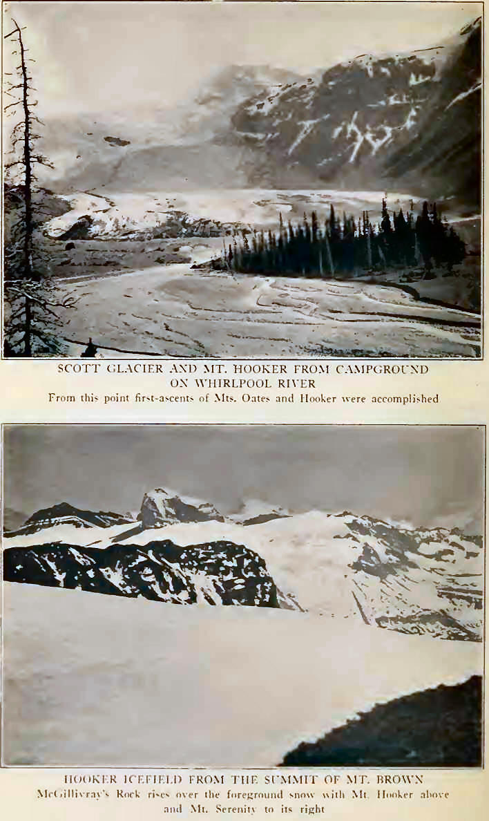
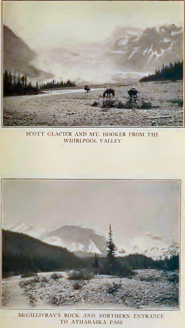
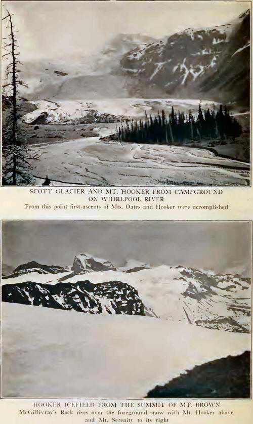
The Scott Glacier will
be much visited in days to come because of the tremendous spectacular
icefalls in which it plunges down to the valley level, to spread in a
broad flat tongue toward the wooded morainal fans far below timber-line.
We passed close below it on our next day’s travel and were to know it
better within a short time. The upper neve spreads below the northern
wall of Mount Hooker, and one must journey far in the Canadian Rockies
to find ice-scenery which can compare with the wild splendour of this
view. The western margin of the glacier is flanked by the symmetrical
rock peak of Mount Evans, contrasting with the sheer snowy wall of Mount
Kane just beyond, resembling the southern portion of the Victoria ridge
above Lake Louise. From the col between Evans and Kane a slender
precipitous icefall hangs in apparent defiance of the laws of gravity,
pale-blue with a tinge of green, and its tiny stream ending in an airy
waterfall that sprays to a rock-bowl close to the trail.
Rounding the shoulder
of Mount Kane, trail leads through evergreen timber and thickets of
pussy-willow, and patches of spring snow. Crowded clusters of anemones
and avalanche-lilies press up through the melting margins. In the shadow
of McGillivray’s Rock, with the snows of Mount Brown ahead, we enter on
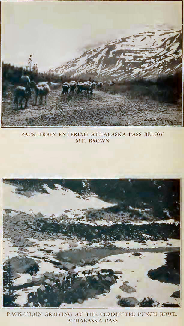
the Athabaska Pass.
The valley broadens
above the gorge at the foot of Kane, snow becomes deeper, entirely
covering the trail; pack-horses, floundering at first, gradually gain
confidence in their footing. A gaunt cariboo stalks up and over a nearby
ridge, moving so slowly. How surprising, to reach the summit lakes on
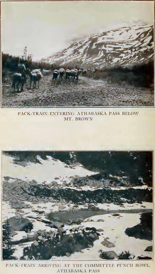
the pass and stop by the central one—the Committee Punch Bowl! A skim of
ice lay on the water, too cold for bathing; and, unlike Coleman, we had
not brought a canvas boat. But one of us can at least be credited with
having swum a horse across the Great Divide! Here Thompson and Douglas
had come; here Ross and Simpson had drunk their wine; here had passed De
Smet and Kane, and all the rest. . . .
The lakes are desolate,
lonely tarns, and in winter may be entirely covered. Of course there are
no lofty mountains on either side, and one is almost at a loss to pick
out Mount Brown, for on the western side of the pass are several summits
all about equal in height and resembling each other in outline. It is
all so plain in Douglas’ journal; a visit to the pass is the really
confusing thing. A traveller of today, writing on the spot, could never
describe the pass and its peaks in Douglas’ words—the journal and the
lay of the land simply do not agree.
On account of the snow,
we placed camp among the trees on Pacific Creek about a mile below the
pass summit, with a group of serrated splintered peaks in view down the
valley of Wood River.
Hoping to reach Mount
Hooker, on June 30th we left camp at 5.20 A. M. Following the north
margin of the glacier-tongue coming from the shoulder of McGillivray’s
Rock and the Kane Icefield, in two hours we had reached the upper snows.
But on crossing to a higher ridge of the Divide, at 9300 feet, we found
ourselves cut off from Mount Hooker’s southern wall by an impassable
snow precipice, overhung with cornices and dropping to the broken Wood
River glaciers of the Hooker Icefield. The arete connecting with Hooker
rises into an intervening peak which would have to be traversed and
forms a route impossibly long for a single day. So realizing that we
were defeated, we followed our ridge northward and tramped the long
stretches of snow to the Kane-Evans col, which we reached over a small
schrund and up some slabby chimneys. We were now at the head of the
hanging glacier which is so striking in appearance when seen from the
Whirlpool, and upward over snow and ledge made our way to the top of
Mount Kane. It was a few minutes after two o’clock when we arrived.
A little to the
southeast there is a break in the curiously banded rock-wall separating
the Kane Glacier and Hooker Icefield, affording a possible approach to
Mount Hooker; but from Athabaska Pass it will be a very long journey.
Beyond the north face of Hooker the view extends to far-away Athabaska
sources, with Mount Alberta, The Twins, and Mount Columbia, stupendous
even through the distances.
The Wood River Group is
seen from an unusual angle and presents a fine array of glacial cirques
on the northwest, by which the flat upper snows of Bras Croche might be
reached and other peaks explored. Yet one hesitates to recommend a visit
by way of Athabaska Pass and the low, timbered reaches of Wood River.
The northern snows of
Mount Kane, so steep they are, seem to overhang the Whirlpool. It was
the first summit from which all four of the 12,000 foot peaks of the
Rockies are visible that any of us had attained. Far beyond the Rampart
Group and southern Fraser sources, our gaze was held by Mount Robson.
Towering nearly two thousand feet above its highest neighbours, its
elevation emphasized by low surrounding valleys, one is yet attracted
more by the mountain’s isolation than by its appearance of height. No
great group masks its precipices. From our viewpoint the peak is a
steep-angled pyramid, slightly blunted in the summit ice-cap, a
streaming glacier continuous with the neve in a vertical rise of nearly
4000 feet, and the southeastern shoulder, conspicuous from the Grand
Forks Valley, so fore-shortened as to be almost unrecognizable.
The west is a chaos of
unravelled topography: the northern peaks of the Columbia Loop, the
Fraser-Canoe divide, the Gold Range, the Cariboos and far peaks of the
Fraser Valley. Long familiarity with the main chain of the Canadian
Rockies cannot dull the overwhelming sense of hopeless awe aroused by
the extent of those unnamed western peaks.
It is not easy or
profitable to describe precisely the Kane traverse. Suffice it to say
that the arete west of the summit affords a delightful climb of several
hours, with work which does not lack in excitement. The snow-ridges
encountered are quite narrow, with airy drops to the Whirlpool Valley;
the arete possesses a blunt central tower, with opportunities for
interesting hand-and-friction traverses on the southern slabs. A last
curling ladder of snow leads to scree slopes, and broken rock descending
to the glacier. We walked home across the Kane field, in the lengthening
shadow of McGillivray’s Rock, and the evening glow on the ranges beyond
Wood River. At precisely 8.20 P. M., Jack was requested to cook an
enormous supper for four!
On the following day we
wandered up Mount Brown, past ice-glazed lakelets on benches of snow,
like gigantic steps, above the Committee Punch Bowl. Then following the
eastern margin of the Brown Icefield, we took what climbing we could
find—the rope was unnecessary—and were soon walking up the long shale
ridge to the top. The ascent took five hours, and we arrived at a
quarter before three; the time was slow, but it was a blistering day and
we were a lazy lot. Still it makes one doubtful whether David Douglas,
under winter conditions and with limited time due to a late start, could
have reached this particular summit.
The Brown Icefield
drains to Canoe River and to Wood River; the peaks on its western
margin, all unnamed, are attractive and should preferably be reached
from a camp at the head of Jeffrey Creek. The unnamed pass through the
Divide, immediately north of Mount Brown, deserves a visit. Three lakes,
icy and varying in hue, form the sources of Robert Creek and drain to
Canoe River. The Wood River and Columbia Groups are practically in line,
Alberta and The Twins visible, but Columbia hidden by square-topped Bras
Croche. Two hours passed; cameras clicked busily, pipes were smoked; we
snoozed in the sunlight. The view delighted us—we could not think of it
as being “too awful to afford pleasure.” In another two hours we had
glissaded merrily back to the campfire, tracking in over the lower
snow-patches just before seven o’clock. |