|
Its History, Geology,
Mining and Manufacturing.
The annual meeting of
the Historical and Scientific Society of Manitoba, Feb. 23rd, afforded
an excellent opportunity for bringing before the citizens of Winnipeg
the resources of the Lake of the Woods region. This falls within the
scope of the Society’s work, as “north and west of Lake Superior” and
the general interest of the people in mineral deposits of the Lake was
sufficient reason for the lecturer of the evening, Dr. Bryce,
undertaking it. The doctor stated that the way in which to meet over
speculation was to give definite and accurate information as to mining
and its conditions. Ignorance, as he remarked, is not only the mother of
superstition, but also the nourisher of feverish speculation and
impracticable schemes. Undoubtedly our mineral resources on Lake of the
Woods are of great value, and will give good returns if carefully and
judiciously developed. The lecturer was assisted by Dr. Laird, president
of the Society, in showing specimens of the rocks of the Lake of the
Woods, and also gangue from several of the gold producing mines. The
lecture vas well illustrated with maps and diagrams. The attendance in
the city council chamber was large and influential and the interest well
maintained. Dr. Bryce said:
“The Lake of the Woods
has now for more than a century and a half been know to voyageurs who
came by way of Lake Superior to the Northwest. Connecting as it does by
water courses to within a few miles of Lake Superior and communicating
with all the inland waters of Rupert’s Land, it is not surprising that
it became famous as an objective point in northwestern exploration. In
late years the Lake of the Woods has become well known as a great
lumbering centre, supplying as its tributaries do large quantities of
pine for this industry. It has also an enormous water power in its fall
into Darlington Bay, which has been utilized to some extent in supplying
power for mills. For a number of years the lake region has been coming
steadily into notice as a mining district. All these reasons justify us
in considering it to-night at the annual meeting of oar Historical and
Scientific Society.
NAME
The earliest name we
find the lake known by is that given by Verandrye in his journey in
1731. He says it was called Lake Minitie (Cree Ministik) or Des Bois.
(1) The former of these names, Minitie, seems to be Ojibway, and to mean
Lake of the Islands, probably referring to the large number of islands
found in the northern half of the lake. The other name (2) Lac des Bois,
or Lake of the Woods, seems to have been a mis-translation of the Indian
name (Ojibway) by which the lake was known. This name (3) was
“Pikwe-dina Sagaigan,” meaning the “inland lake of the sand hills,”
referring to the skirting range of sand hills running for some thirteen
miles along the southern shore of the lake, to the east of the mouth of
the Rainy river, its chief tributary.
Another name found in a
map prepared by the Hudson’s Bay Company in 1748 is (4) Lake Nimigon,
probably meaning “the expanse,” referring to the open sheet of water now
often called “la traverse.” Two other names, (5) Clearwater Lake and (6)
Whitefish Lake, are clearly the extension of the Clearwater Bay, a
northwestern part <>f the lake, and White-fish Bay, still given by the
Indians to the channel to the east of Grande Presqu’ile.
HISTORY
The Lake of the Woods,
though sometimes referred to by French Canadian authorities at an
earlier date, was first reached by Verandrye in 1732. The earliest
references were no doubt obtained from stories of Indians heard on Lake
Superior. Verandrye’s notable voyage has been often described. In 1731
Verandrye’s party, as late as the month of August, was ready to leave
Lake Superior to find their way inland. The journey promised to be
severe, and a part of the company mutinied. Verandrye himself spent the
winter at the Kainmistiquia, on the shores of Lake Superior, but his
nephew, La Jemeraye, pushed through and built a fort at the head of
Rainy River, which runs into the Lake of the Woods. This fort was called
St. Pierre, and traces of it were found a few years ago by the writer at
Coutchecheng, three miles southeast of the village of Fort Francis.
In June, 1732, the
party urged on their explorations, and descending Rainy River, reached
Lake of the Woods. They directed their way now to the southwest shore of
the lake, where they built Fort St. Charles. Passing on to the interior
from the Lake of the Woods, they explored with great energy the water
courses of the west. The Lake of the Woods was the scene of a great
tragedy so far as the Verandryes were concerned. The Sioux, or Dakotas,
of the west were in the habit of coming at times to the west side of the
Lake of the Woods. Stealthily they lay in wait for a part of the
expedition that was returning from the interior in 1736. This party was
led by Sieur de la Verandrye, eldest son of the veteran Verandrye. A
little island, still pointed out between Hay Island and Cornfield
Island, is said to be the scene of the disaster. Attempts have been made
lately by interested parties to place Massacre Island near Rat Portage.
For this there is no evidence.
The Verandrye party
consisted of the Sieur, a Jesuit priest, Father Anneau, and twenty men.
According to the report of a voyageur named Eourassa, the bodies were
discovered on Massacre Island five days after the murder. “The heads of
the dead Frenchmen were placed upon beaver skins, the greater number of
them scalped. The missionary had one knee on the ground, an arrow in his
head, his breast cut open, his left hand upon the earth, and his right
uplifted. The Sieur de la Verandrye lay face downward, his back hacked
with a knife, a hoe buried in his loins, and his headless body
ornamented with porcupine garters and bracelets." The Crees and
Aesiniboines, allies of Verandrye, offered to enter upon a war with the
Sioux, their heriditary enemies, to avenge the massacre, but Verandrye
feared the consequences of such a movement and declined the offer.
Charles Lindsey in his
“Report on the Boundaries of Ontario” says: “The Lake of the Woods is
memorable in geographical and diplomatic history. It has been the
starting point in every treaty of the boundary line between the Dominion
of Great Britain and the territories of the United States.
No doubt in this
statement Lindsey had reference to the settlement of the boundary by the
treaty of 1783. At that time the British commissioners in Paris had few
maps, and these very imperfect, of the country west of Toronto. The
American commissioners had at their elbow a fur trader, Peter Pond, an
American by birth, who had been in the employ of the Montreal fur
merchants, and had charge of a post in the far distant Athabasca. It is
said that Pond “designated a boundary line through the middle of the
upper St. Lawrence and the lakes and through the interior countries to
the northwest corner of the Lake of the Woods, and thence west to the
Mississippi.” The northwest angle of the Lake of the Woods has
consequently ever since been a notable point.
The impossibility of a
line westward from the northwest angle of the Lake of the Woods to the
Mississippi led to the agreement in Jay’s Treaty of Amity and Commerce
of 1794 “to survey the upper Mississippi in order to fix the boundary in
that region.” In 1816, at the Treaty of Ghent, promise was made for a
commission to settle the boundary to the Lake of the Woods, east and
west. At the convention of London, in 1818, the commissioners appointed
under the terms of the Treaty of Ghent succeeded in closing the matter.
It was agreed to draw a line north and south from the northwest angle of
the Lake of the Woods until it met the 49th parallel. An unexpected and
amusing result of this mode of settlement is that a small peninsula of
Canadian territory has a portion of the extremity cut off by this line,
and this small section is American territory, being surrounded by
American waters.
The Lake of the Woods
became the highway for almost all the expeditions and journeyings of
voyageurs from the Lake Superior district to the interior of the
Northwest. The usual course was to cross from the mouth of the Rainy
river to the head of the Winnipeg river, and, descending it, to reach
the interior. In the winter of the year 1817, Lord Selkirk’s band of De
Meurons, in order to outflank the Nor-Westers, left Lake of the Woods,
probably about Buffalo Bay, on the southwest side of the lake, crossing
somewhere along the boundary line of 49 N. and reached Pembina, from
which place they came down the Red River and surprised and captured Fort
Douglas.
The Hudson’s Bay
Company, in course of time, found it advantageous to have a post at the
exit of the Lake of the Woods. They accordingly built a post on the
narrow neck of land, probably not far from the present town of Keewatin,
at a spot where was the original and true Rat Portage, but the company
is still represented in the town of Rat Portage by its place of
business.
The circuitous and
difficult route by which the prairies were reached down River Winnipeg
and by the stormy sheet of Lake Winnipeg led to the use of the natural
entrance on the west side of the lake known as the northwest angle some
thirty or forty years ago. The expedition conducted by Dawson and Hind,
in 1857 and succeeding years, led to the desire to open this more direct
connection between Lake Superior and Red River. In 1867 the Canadian
government built six miles of a wagon road from Thunder Bay to Dog Lake.
In 1868 the Red River end was begun with the purpose not only of opening
up communication, but also of giving relief to the people of Red River,
who were suffering from the ravages of grasshoppers. Mr. John A. Snow
was the contractor in charge. He undertook to build the portion from Red
River to Pointe de Chene—the prairie section—over a distance of about 30
miles. The continuation of this road was made to the northwest angle of
the Lake of the Woods, and the road, some 110 miles in length, was known
as the “Dawson Road.” This road was afterwards a part of the famous “
water stretches ” route by which Mr. Mackenzie for several years brought
settlers to Lake Superior through Lake of the Woods to Red River. The
Wolseley expedition, in 1870, followed the Winnipeg River, instead of
the Dawson route. Thus has Lake of the Woods, from its position, again
and again become an important factor in the geography and history of the
Northwest.
GEOLOGY
The Lake of the Woods,
which has an area of 36,000 miles, is divided naturally into two parts,
the southern, which is largely an open sheet of water and somewhat
shallow, the northern tilled with a multitude of rocky islands. This
division arises from the geological features of the basin in which the
lake lies.
The southern portion
rests on the Laurentian strata which are the oldest stratified rocks
with which we are acquainted. The Laurentian rocks consist chiefly of
gneiss rocks changed by metamorphic action, and these are lined along
the lake shore with beds of sand, which in the neighborhood of the mouth
of Rainy River, the chief tributary of the lake, rise up as dunes and
are seen for a considerable distance.
The northern division
of the lake is made of rocks which are much softer and are cut up into
innumerable inlands. They belong to the geological period known as
Huronian, although Mr, Lawson, of the geological survey, to whom we are
indebted for many of our facts, states that they are not quite identical
with the Huronian of the shore of Georgian Bay. He proposes to call our
western formation the Keewatin. The general inclination seems to
prevail, however, to hold to the name Huronian, and we may follow it.
This formation is
notable as being found superimposed in long bands, or stretches, upon
the Laurentian. The Huronian is generally regarded as a shore line
formation. It is besides very much contorted and disturbed, and it is
generally supposed that it has been thus affected by the intrusion.
of masses of granite
rock, and by the natural crumpling or folding of the earth’s surface,
which is still going on, and which in former times assumed very great
proportions.
The rocks of the
Huronian are the mineral-bearing rocks, or at least contain veins of
various kinds, having gold and other minerals of value. It has been the
custom to connect these veins in some way with the changes resulting
from the intrusion of the granite near by.
A study of the rocks of
the Huronian on the Lake of the Woods shows that the belt of rock has
been crumpled up into five ridges, which the geologists call antielinals,
and that these run either northeast or southeast across the upper
portion of the lake.
1. The most southern of
these antielinals is shown in a series of Laurentian islands, such as
Bigsby, Big, Massacre and Cornfield islands, and leading over to
Driftwood point on the west shore.
2. The second great
ridge, enormous indeed in proportions, includes the great dividing
peninsula of the lake, known as the “Grande Presqu’ile,” which, leading
through Falcon Island, passes to the opening made by the northwest
angle.
3. The next anticlinal
wa& that formed by the eastern peninsula, pointing northwestward, and
connecting by islands with the western peninsula at Crown Bock channel.
4. The fourth
anticlinal, or ridge, w as that traced along Pipestone Point and three
islands, viz: Hay, Middle and Scotty Islands, and it may be mentioned in
passing that this is an important neighborhood. This line of direction
leads to Point Aylmer, on the outer extremity of the northern peninsula.
5. The fifth and most
northerly of the original ridges is a short distance from the town of
Rat Portage, starting from the well-known Devil’s Gap, and leading by
islands across to Dispute Point.
These four most
northerly ridges diminish in size from south to north,, and each time
become smaller in width until at the north the end of the lake is
reached by the farthest north extent in this district of the Huronian
strata. This forms a narrow rocky neck, having the waters or the Lake of
the Woods on the southern side and on through the beginning of the
Winnipeg River, known as Dailington Bay. This is at a level considerably
lower than that of the lake.
Between the western and
northern peninsulas a long, narrow strait runs through the Huronian
strata. It is called Ptarmigan Bay; this again leads by passing Ash
Rapids and through the narrow Shoal Lake channel to Shoal Lake, a body
of water somewhat higher than Lake of the Woods. Shoal Lake is
triangular in shape with a greatest north and south measurement of
thirteen and a half miles, and a greatest breadth of seventeen miles.
This has as we shall see become famous as having mineral deposits of
value. An eastern extension of the lake, named Whitefish Bay, shut in by
the base of the Grande Presqu’ile, lies almost entirely in the
Laurentian basin, though its northern and eastern shores are Huronian
and contain mineral deposits.
ROCKS
1. The rocks of the
Laurentian formation of the south end of the lake are, as has been said,
hard gneissoid rocks.
2. The softer schist
rocks of the north end of the lake are much more varied in species. Like
the Laurentian they are all stratified rocks, which have gone through
the process of metamorphism by heat. If there ever were any fossils in
them all traces of these have been removed. Near Rat Portage these rocks
are slaty quartzites and siliceous schists. The greenish rock known as
chloritie rock of hornblende and feldspar is found at different points.
Talcoid schists and siliceous diorites are come upon, but in general the
rocks of the whole series are made up of coarse laminated schists. The
arrangement of the rocks made by Lawson is: 1. Mica schist on the
surface; 2. Agglomerate schist below this; and, 3. Hornblende schist
lowest down, resting on the Laurentian gneiss. The thickness of these
beds varies much ; hut an estimate is made by Lawson that the average
thickness of the whole Huronian formation may be set down at 23,750
feet, or four and a half miles.
3. The presence at
various points in the Huronian of intrusive granitic rocks is very
noticeable and significant. This rock is found at ten main centres
through the area of the Lake of the Woods district, such as Rossland
station, Yellow Girl Point,, the Northwest Angle, Portage Bay, etc.
The occurrence of
granitic intrusive rocks is of prime importance in considering the
bedding of the Huronian formation, in finding the direction of
metalliferous veins and in dealing with the question of metamorphism.
SURFACE ACTION
The rocks of the Lake
of the Woods region would seem to have been always somewhat level in
their general outline. There were no precipitous cliffs and great
valleys such as are found in mountainous regions. No doubt the soft
rocks of the northern section would be much worn away by the denuding
agencies occurring during the long periods of time which have elapsed
since their formation and elevation above the sea. The glacial action
is, however, very clearly followed on the surface of the existing rocks.
Lawson says: “The Lake of the Woods and surrounding country may be
considered essentially as a partially flooded area of ‘roches mouton-nees'”
i.e., rounded hummocks and even large islands. The whole country is
scraped bare, polished and grooved. The rocks everywhere bear evidence
of this general action. Striae showing the direction have been found in
upwards of 200 locations on the islands and rocky shores of the lakes,
and these have a general southwest direction.
A curious question has
arisen as to the origin of certain limestone boulders found along the
shores of the Lake of the Woods. No rock of this kind is known east or
north of this region, at least on the southern slope. These limestone
boulders are a peculiar feature of the south end of the lake. Three
different theories have been used to account for this.
1. It has been
suggested that there may he a limestone floor for this part of the lake.
2. The limestone might
have been derived from the Hudson Bay slope, where such locks occur.
3. The limestones are
erratics from the Red River Valley.
As to these views there
is no evidence of a limestone floor for Lake of the Woods; in fact,
thereis every probability against it. In regard to No. 2, it would seem
impossible to imagine any agency by which the great region of rocky
country between this region and Hudson Bay could have been overcome. The
third supposition is plainly most reasonable. In the glacial period we
know that a great glacial lake covered the Red River Valley and extended
to the east shore of the Lake of the Woods. The glacial action in the
Red River Valley was very great, and no doubt fragments of the limestone
were carried southeastward from it to the basin of the Lake of the
Woods.
MINING
The contorted strata of
the Huronian rocks, thrown about as they have been by granitic
intrusions, naturally had many crevices, faults, fissures, broken seams,
cracks and openings in their structure. The intrusive rocks would
liberate in their upheaval great bodies of lava, steam and boiling water
from the vast depths below. These would have the metals in a state of
solution. The crevices and faults of the Huronian would be filled and
gorged with the gaseous, or liquid, heated matters
From the wide-spread
character of the mineral substances, such as sodium, potassium,
manganese, iron, copper, and even gold and silver in sea water, and in
many sea animals and plants, it may be learned what the waters thrown up
from the great depths would contain. The cooling down of the materials
thus carried in by water and steam makes the veins. The kind and
character of the vein depends on the shape of the crevice or opening
when the intrusive solid matter is deposited and solidified.
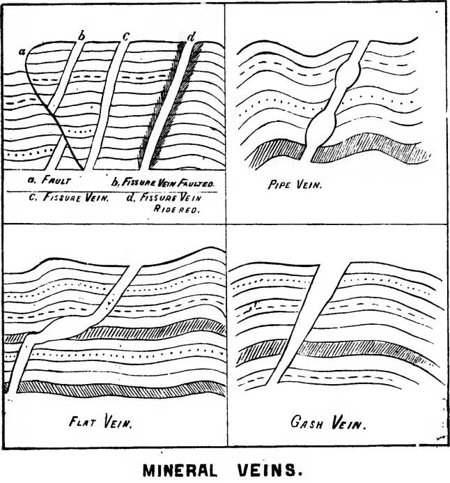
Four chief varieties of
veins have been named depending on these conditions:
1. Rake or fissure
veins. These are perpendicular, or nearly so, in direction, and vary
little in width as they descend.
2. Pipe veins are much
like fissure veins in direction, being often nearly perpendicular but
they are irregular in width, and are subject to great variations, being
now very wide and then very narrow in diameter.
3. Flat veins or
striaks. These are a variety of fissure veins which change their
direction and run along parallel to the beds.
4. Gash veins are those
which resemble fissure veins, but are wide at the top and gradually
narrow to a point until they disappear.
The vein is from its
nature shut in by walls. These walls, if cracked when the vein matter or
gangue was deposited, were often penetrated by portions of the liquid
intrusive matter, and so the wall rock contains at times, many feet from
the vein, traces of the vein material. When strings of the vein material
thus penetrate the wall rock, the rock is spoken of as “ridered,” though
miners wrongly call these strings “feeders.” Sometimes the same mineral
as that of the vein may be found in pockets or nests adjoining the vein.
In some veins the
richer part of the vein is in the centre, and there seems a regular
arrangement of the different minerals according to the specific
gravities of the minerals.
When veins cross one
another it is found that the place of junction is very rich in mineral
deposit. This is really not accounted for, but is said by some to depend
on thermal or even on electric conditions. Contents of veins are often
found to vary with their depth. The length of a vein is hardly ever
known. The richest veins are productive for a while, but their fissures
may be filled with other materials than those desired, or may cease
altogether. Some, however, are known to extend for several miles. Veins
vary greatly in
width. One twenty
feet wide wculd be considered quite remarkable ; most veins are less
than six feet in width.
“Gold is always native,
always alloyed with silver, and contains small quantities of copper and
iron. Iron pyrites almost always contains gold. Gold usually occurs in
quarz veins, which are sometimes in granite.”—Phillips.
MINE CENTRES
The geological
conformation gives indications in many cases where the mines are likely
to be. The following points are worthy of consideration:
1. Generally on or near
the Huronian deposits the mines are found.
2. Usually in the
neighborhood of granitic intrusive rock.
3. Almost exclusively
in the Lake of the Woods region in quartz rock.
4. According to Lawson,
in many instances the granitic cores of rock are overlaid on the shore
of the lake by skirts of Huronian rock.
5. (a) The localities
seemingly most developed with success are the districts a few miles
southeast of Rat Portage where the Sultana, Pine Portage and other mines
are found.
(b) Rossland station,
some eight miles east of Rat Portage, is the centre of a number of mines
of which the Scramble, Sweden, and others are spoken of.
(c) Big Stone Bay has
in its neighborhood a number of localities, and the Master Jack is being
worked.
(d) The neighborhood of
Whitefish Bay, to the east of the Grande Presqu’ile, has the Regina, La
Mascotte and many other locations.
(e) The Shoal Lake, on
the west side of the Lake of the Woods, where the Mikado, Gold Coin and
many others occur, has received attention.
The Wabigoon district
lies on Huronian horizon, and is being explored and examined. Though
belonging to the Rainy River, as being one of its tributaries, yet the
Seine river, running along a stretch of Huronian locks, lies very little
south anil is within two degrees east of the south end of the Lake of
the Woods.
These are hut very few
of the many points taken up by companies and prospectors. That some of
them are well-paying properties does not say that they are the only rich
mines. The districts quoted are miles apart and are scattered over no
less a region than of fifty miles square. There seems no good ground for
s lying that all the good locations are taken.
6. The possibilities of
failure are:
(a). The circulating of
false or misleading information about localities.
(b) The substitution
under the name of one mine of assays from samples of ore taken from
recognized rich mines.
(c) The returns made by
incompetent analysts, not to speak of fraudulent agents.
(d) The running out of
veins which may prove good for a time.
(e) The lack of money
to develop.
(f) The difficulty of
guarding against dishonest employees, even when gold is secured.
Unioubtedly there is
room and much need for the governments of Ontario and Manitoba, which
are interested in this matter, having laws on mining, organizing
competent scientific departments, under which precautions may be taken
to protect the public from deceit, and giving true assays of ore, with
certificates of the localities and the like. A government certificate
should be issued only under the strictest regulations
MANUFACTURING
1. The splendid sheet
of water found in Lake of the Woods, with its important tributaries, has
for years given opportunity for the important industry of lumbering.
Excellent timber is obtained from the banks of the streams leading into
Rainy River. Great numbers of logs are every season brought down to
where the Lake makes exit into Winnipeg river and manufactured for the
uses of the prairie settlers. The saw mills of Messrs. Cameron, Mather,
and others are dotted along the etrata of the lake for some three miles.
2. The presence of
large quantities of spruce, birch and poplar upon the feeders of Lake of
the Woods, along with the splendid water power of the lake, has
suggested the making «>f pulp for the manufacture of paper. The timber
can be cheaply obtained and delivered, and the passage of the railway
through the neighborhood of the water-power gives every facility for
advancing this important industry. It has also been suggested that the
nearness of the prairies might well be utilized to grow flax for the
manufacture oi high grades of [taper. It is said that 1,281,354 bushels
of flax seed were produced in Manitoba in 1895. To be able to use the
straw would be an addition to the farmers’ income. The manufacture of
barrels and wood ware is also a feasible industry.
3. The first
advantage', other than in the working of wood, has been taken of the
water power in the manufacture of flour. This must ever be a chief
industry in the Northwest. The Lake of the Woods Milling Company, which
began operations about ten years ago, has since, along with the Ogilvie
Milling Company, of Winnipeg, been doing an enormous business. To those
of us w ho remember the suspicion with which our Manitoba wheat was
looked upon as a flour producer twenty-five years ago, it is a great
gratification to know the high place which Manitoba flour has taken in
the markets of the world. The output of this mill last year was very
large.
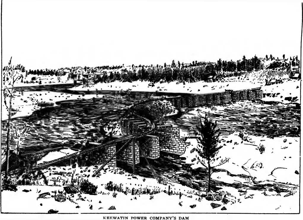
4. As the basis of
these manufactures, which may render the Rat Portage and KeewTatin
district worthy to be called a great manufacturing centre, there is
certainly to be mentioned as important the service rendered by the
Keewatin Power Company. In order that the full power might be utilized,
it has been found necessary to dam one of the outlets of the lake at a
considerable cost. We are fortunate through the courtesy of the “Flag”
newspaper, of Ottawa, in being able to publish a cut of the dam of the
Keewatin Power Company.
This will show the
magnitude of the work already undertaken and accomplished. As is well
known this company proposes to supply electric power not only for local
purposes, but also for places at as great a distance as Winnipeg.
Looking at the
resources of the Lake of the Woods district, we may well wonder at the
richness of our Northwestern heritage. While discouraging all hooining
and unnatural development of our resources, it is but right that we
should encourage legitimate work in making use of the treasures of
nature belonging to us. We shall be glad if Rat Portage and Keewatin
grow to deserve the name already given by some, of the “Minneapolis and
Denver of the Canadian Northwest.”
|