|
The Panorama from Mt.
Columbia, 12,294 Feet (Second Elevation: Rocky Mountains of Canada)
The mountaineering
results of an Expedition to the Columbia Icefield, made, in 1923, in
company with Dr. W. S. Ladd and the guide Conrad Kain, have already been
presented in Chapters V-VII.
On July 14, in fine
weather, we accomplished the second ascent of Mt. Columbia, and for
several reasons interest has centred in a photographic panorama obtained
from its summit.
In the first place,
there are but four peaks—Robson, Columbia, North Twin, Clemenceau—of the
Rocky Mountains of Canada exceeding 12,000 ft. in elevation. Mt.
Columbia was first ascended in 1902 by Sir James Outram and Christian
Kaufmann. Mt. Robson, 12,972 ft., succumbed in 1913 to Messrs. MacCarthy
and Foster, with Conrad Kain. North Twin, 12,085 ft., fell to our party
in 1923, while later in the same season Mt. Clemenceau, 12,001 ft., was
captured by the guideless party of Messrs. de Villiers-Schwab, Hall,
Durand, and Harris.
Outram was favoured by
clear weather on Mt. Columbia and has graphically described the view.
The summit was reached shortly after two o’clock and an hour was spent
on top. . . . “Thirty miles to the south-east Mt. Forbes (as yet
unconquered) towered high above everything in that direction, and alone
challenged comparison with our elevation. But at twice that distance to
the northwest Mt. Robson showed up grandly and is perhaps the one
mountain in the Canadian Rockies that exceeds 13,000 ft. . . . Some old
friends in the distant south, fully eighty miles away, Mts. Temple,
Goodsir, Hungabee, Dawson, and Sir Donald, and more recent acquaintances
of the past fornight, gave one great pleasure to recognize amongst the
myriads of peaks of every shape and size.” Outram never published his
summit views.
The first party to
reach the summit of Mt. Robson arrived after five o’clock, and, although
the prospect was fair, they had no camera and could stop for only a
moment.
Our own group attained
North Twin, in weather that was far from ideal, and so our pictures from
Mt. Columbia are the first to give a comprehensive idea of a Canadian
Rocky panorama from above 12,000 ft. It is, therefore, of some interest
to determine just what and how far one can see. It will be quite
evident, however, that while the eye can perceive things beyond the
range of photography, the camera preserves the record permanently and
more accurately than the mind. The after-cogitation—“Now just what did
we see?” —led to some remarkable delusions in the days before
photography: witness the prevalent pre-Alpine Club opinion that the
Mediterranean was visible from the summit of Mont Blanc.
It is the purpose of
the present communication briefly to outline what was revealed from the
summit of Mt. Columbia, 12,294 ft., the second elevation of the Canadian
Rocky Mountains. The photographs were snap-shots, 4 by 5, taken on
roll-film, without filters other than a cloud filter which did not alter
the exposure time. The complete, drafted panorama has been made from
tracings from the prints, plus additions obtained by lens examination of
the negatives and from enlargements. (See insert facing p. 80.)
The central position of
Mt. Columbia is emphasized if one draws on a map—with the mountain as a
centre—a circle of radius approximating forty-two miles. The
circumference will nearly pass through the tip of the Columbia loop, the
Columbia River-Canadian Pacific intersection at Beavermouth, Howse Pass,
and Whirlpool Pass. Within the circle are included Kinbasket, Glacier,
Brazeau, Maligne, and Fortress lakes, and headwaters of the Columbia,
Saskatchewan, and Athabaska River systems. Within it are found the most
important icefield groups of the Continental Divide, together with the
notable Maligne and Wood River mountains, and the crest of the Selkirks
in the Sir Sandford area.
From the summit of Mt.
Columbia, the foreground of icefield is perhaps the most impressive
thing. The Columbia field is a tri-oceanic watershed, nearly 150 square
miles in extent, from whose snows drain head-sources of the Athabaska,
through the Peace-Mackenzie system to the Arctic; through the
Bush-Columbia to the Pacific; and by way of the Saskatchewan-Nelson
system to Hudson Bay.
Northward, one has the
Twins and Mt. Alberta almost in line; the Twins above the deep gorge of
the banded Columbia glacier, an Athabaska source. On either side of
North Twin are peaks of the Maligne group, Mt. Brazeau standing out
prominently although twenty-five miles distant.
In the north-east are
many unnamed peaks—one does not have to wander far from the Continental
Divide to find unnamed peaks— several of which, south of Brazeau River,
exceed 10,000 ft. and may be much higher.
Eastward, one looks
across the icefield toward Snow Dome, the hydrographic apex of the
field, and Mt. Athabaska, the latter rising above Sunwapta Pass—the
Athabaska-Saskatchewan divide—with Athabaska glacier on its northern
flank and the Saskatchewan glacier on its southern.
In the south-easterly
direction, Mt. Castleguard is seen, low-lying on the margin of the
icefield, with Mt. Saskatchewan towering above and flanking Alexandra
River—the old “West Branch”—down which one glimpses Mts. Wilson and
Murchison, between which the North Saskatchewan emerges to the eastern
prairie. Across Thompson Pass are massed the peaks of the Continental
Divide: Alexandra, Lyell, and a host of others. Mt. Forbes, 11,902 ft.,
the fifth elevation of the chain, lies in Alberta, but, due to a bending
of the Divide, it appears just over Peak 3 of Mt. Lyell. It is this
irregularity of the Divide, in the vicinity of Howse Pass, which makes
the Freshfield Group show up across the western shoulder of Mt.
Alexandra, and between the latter and Mt. Bryce.
In the south, Mt.
Bryce—a veritable Finsteraarhorn—its eastern shoulder on the Divide,
projects into British Columbia to flank the gloomy gorge of Bush River.
One traces the river with certainty past the junction of the North and
South Forks, but it cannot be followed to the Columbia.
South-westerly, across
Tsar Creek, are extensive snowfields and, more distant, high peaks:
presumably within the tip of the Columbia loop. The foreground is a sea
of unnamed peaks.
The western foreground
is dominated by Mt. King Edward, icefields mantling the Divide, and,
except when broken into different levels by crossing ridges, continuous
for miles toward the Wood River area. The distant named point in the
west is Alt. Tsar.
In the north-west,
thirty miles away, is the Wood River Group, on the British Columbia
side: most impressive, with Mt. Clemenceau looming hugely. One looks
across the glacier-hung Athabaska-Chaba Divide to ranges in the
direction of Fortress Lake.
So much the camera
identifies as a permanent record; now of what the eye could reach.
Outram mentions the peaks of the Lake Louise district; we looked for
them in vain. Temple was nowhere to be seen; although, of course, from
Mt. Temple, on a clear day, especially if one looks with binoculars,
there is not much trouble in finding Mt. Columbia. But from Columbia, in
the south and southeast, the Continental Divide is seen in a
foreshortened line: the peaks are massed, and of such an average height
that it is exceedingly difficult to locate distant individuals from an
unfamiliar point. Even Mt. Forbes was not a conspicuous summit, although
little more than thirty miles away. It will then be recalled that Lake
Louise is seventy-five miles in air-line from Mt. Columbia. It should be
remembered that Outram was exceedingly familiar with this topography,
having mapped a considerable portion of it.
Taking it for granted
then that Lake Louise peaks are visible from Mt. Columbia, or vice
versa, let us lay out a circle from Alt. Columbia, on a seventy-mile
radius. It will cut Lake Louise; it will cross the southern Selkirks
just north of the Beaver-Duncan Pass and the Battle Range. Following on,
the circumference just touches Clemina station on the North Thompson
River and again cuts the Canadian National Railroad, midway between
Yellowhead Pass and Moose Lake. Fraser sources and all of Jasper Park
are included in the circle.
Our party spent nearly
an hour and a half on the summit of Mt. Columbia; we had arrived at
1.30. In the south-east the most distantly identifiable points were
peaks of the Freshfield Group— Mt. Forbes, and Mt. Chephren near Howse
Pass. If we had known exactly where to look between summits, we might
have located a peak in the Lake Louise area.
In the south and
south-west, the horizon was sharper and the peaks not so massed as on
the Divide. Sir Sandford was distinct, although it does not show in
photos. We thought we recognized Mt. Rogers; one can, of course, see Mt.
Columbia and even the Wood River area from Mt. Rogers. Conrad, ever
optimistic, attempted to show us the Purcells and even identified the
Howser Spires. We were not entirely convinced. In the west, we saw high
snowfields which are possibly in the Gold Range.
The question arose as
to Mt. Robson. Conrad had been on the first-ascent of it; the writer had
camped north of it in a former year. We had no small-scale map with us.
The mountain should appear between the Wood River Group and the
direction of Fortress Lake. Mt. Clemenceau was splendidly in view and
there were fine peaks beyond, outside of photographic range. But we were
never sure of Mt. Robson; we felt that we should have seen it; Outram
had seen it.
A remaining fact is
this: if one draws from Mt. Columbia as a centre a circle seventy miles
in radius it will include the Lake Louise area. From Mt. Temple, the
highest peak of this area, Mt. Columbia is visible; but with some
difficulty and only in the best of weather. On the other hand, peaks on
the Divide, massed in line, are exceedingly difficult to identify
individually. The position of Mt. Robson, almost due north-west of Mt.
Columbia, falls at least twenty-five miles beyond the seventy-mile
radius already laid down as approximately the limit of visibility.
Outram speaks of Mt. Forbes as being thirty miles to the south-east,
just about correct. But when he states that Mt. Robson showed up grandly
at “twice that distance to the north-west,” he is nearly forty miles
short of his mark.
From the direction of
Mt. Columbia, Mt. Robson would present an acute A-shape, narrow and
sharp, and easily over-looked, even by an observer with binoculars.
Local conditions, such as light, shadow, smoke, cloud, and heat-haze,
have often more to do with visibility than mere distance. A small peak
in line with a greater one may hide it at such a distance.
Mt. Robson often has a
cap of cloud which might easily render it invisible; and, from Mt.
Columbia, many high peaks of the Continental Divide intervene. One
concludes, therefore, that, while Mt. Robson—under very exceptional
circumstances—might be picked up from the summit of Mt. Columbia, no one
has yet done so. It would certainly not “show up grandly”; and it is
barely possible that Outram was looking at Mt. Clemenceau.
It used to be quite
traditional to make high level panoramas in the Alps. Here is an
interesting problem and a chance to amplify and carry on a bit of
investigation in the newer Alps of Canada.
It is understood that
Binoculars were used in identifying peaks.
Mt. Wheeler from Abbot
Pass____________65 miles.
Mt. Assiniboine from
Mt. Sir Donald--------82 miles.
Mt. Clemenceau from Mt.
Rogers---------------70 miles.
Mt. Robson from Mt.
Unwin----------------------------75 miles.
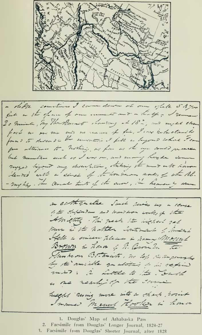
A Note on the Original
Journals of David Douglas
(A Re-examination of
the Problem of Mount Brown and Mount Hooker)
“ . . . the researches
of many antiquarians have already thrown much darkness on the subject,
and it is probable, if they continue, that <we shall soon know nothing
at all.”—Mark Twain.
Few problems more
interesting have arisen in the mountaineering history of the Canadian
Alps that that occasioned by the Scots botanist, David Douglas, who, in
1827, incorrectly ascribed tremendous elevations to the peaks of
Athabaska Pass, which he named Mount Brown and Mount Hooker, For nearly
three-quarters of a century they were considered the highest mountains
of North America, and only recently has the legend been dispelled.
Douglas’ journals, the
earliest documents describing the ascent of a peak in the Canadian Rocky
Mountains, were published almost a century later by the Royal
Horticultural Society in a most carefully edited monograph which has
been the standard work referred to by commentators. The original
journals, strangely enough, appear never to have been consulted by
anyone with mountaineering experience—a fact that induced me, during a
visit to London, to investigate the problem at its source. It is my
intention here to record the results of my examination of these
manuscripts and to show their inter-relation with other data concerned
in the origin of the mythical heights of the Athabaska Pass region.
In the preface to the
Royal Horticultural Society’s monograph it is stated in regard to the
journals that:
1. The handwriting is
nowhere easy to read, and in places most difficult, occasionally if not
quite impossible.
2. In the course of
nearly one hundred years the ink has faded and become in places very
hard to decipher.
3. After the diary of
his journey in North-Western America had been prepared for the press and
set up in type, a second manuscript was discovered which at first sight
was taken to be a duplicate, but which on closer examination was found
to contain a great deal of additional information. It had therefore to
be compared word for word with the diary and the additions inserted in
their proper places.
Both the diary, often
spoken of as the “Longer Journal,” and the manuscript discovered later,
the “Shorter Journal,” contain accounts of Douglas’ crossing of the
Athabaska Pass in the spring of 1827. Only the “Shorter Journal”
contains the names, Mount Brown and Mount Hooker, and makes mention of
the supposedly great height of Mount Brown. The “Longer Journal,” while
describing the ascent of a peak, leaves it unnamed and gives estimates
which more nearly agree with modern surveys.
The passages which
concern the Brown-Hooker problem have already been quoted in Chapter X
(pp. 156-59), where the two versions may be contrasted.
It has been suggested5
that the Longer Journal was the original journal and that the Shorter
Journal was written later, after Douglas’ return to London, and that
names and heights were added at that time. No proofs were advanced for
this supposition and there remained doubt as to which of the journals
was the earlier.
I. General Comparison
of the Two Journals
1. The Shorter Journal
consists of fifty-six pages, 8 x 13 inches, written on each side of each
sheet, with two-inch blank margin at the left. It bears the caption, “A
Sketch of a Journey to the North-Western Parts of the Continent of North
America During the Years 1824, 1825, 1826, and 1827 ” is signed with the
initials, “D.D.,” and is apparently a prepared paper. The writing is in
a large, bold, even, legible hand, and the manuscript is fresh in
appearance.
It was thought by some
that the altitude given for Mount Brown in the Shorter Journal might
possibly have become illegible with time and therefore incorrectly
copied during the preparation of the Royal Horticultural Society’s
monograph. This is not so: on page 47 of the original, the passage, “ .
. . exceeds 6000 feet 17000 above the sea,” is exceedingly clear and
legible, and no mistake has been made in copying.
2. The Longer Journal
consists of 131 pages, 8 x 13 inches, closely written on each side of
each sheet, without margins, and with occasional notes written
vertically at the left-hand edge. The handwriting throughout is smaller
and more compressed than in the Shorter Journal; the paper is the worse
for wear, and entries appear to have been made over a long period of
time.
II. Relative Dates of
the Two Journals
A decisive clue to the
dates of the two manuscripts is given in the watermarks of the paper.
On the page of the
Longer Journal may be found the mark, “J. & T. Jellyman 1824,” while on
the facing page is a crowned seal with the figure of Britannia seated.
On the page of the
Shorter Journal one finds the mark, “C. &
H. 1828,” and on the
facing page a crowned seal with a lion rampant.
Douglas left England in
July 1824, and crossed Athabaska Pass, eastward bound, in the spring of
1827, arriving at York Factory on August 28, 1827. He, therefore, could
not have had with him the paper, watermarked “1828,” on which the
Shorter Journal is written. The watermark, “1824,” on the pages of the
Longer Journal is quite consistent with Douglas’ period in the field.
From these facts we see
that:
1. The Longer Journal
is the field journal, in which entries were made from July, 1824, until
August, 1827'.
2. The Shorter Journal
was written after Douglas returned to England, probably during the
latter part of 1828, during a period of comparative leisure, as shown by
the large, even handwriting and broad margins—men in the field do not do
things so neatly. The manuscript was possibly prepared for reading
before the Royal Horticultural Society which had sponsored his journeys.
3. In the Longer
Journal, Douglas speaks of the mountain which he ascended as being “on
the left hand or West side” of Athabaska Pass; in the Shorter Journal he
describes Mount Brown as “the highest peak on the North or left hand
side.” This may have been a slip of the pen during transcription. Mount
Brown is on the western side of Athabaska Pass, and Douglas has given
its correct position in his 1829 map. This point will receive further
consideration.
4. The names, Mount
Brown and Mount Hooker, were not given in the field, but were added
later when the Shorter Journal was written, no doubt as much out of
compliment to Douglas’ patrons as to distinguish topographical features.
This would also account for the alteration of the statement in the
Longer Journal, “ . . . mountains such as I was on, and many higher,” to
“the highest yet known in the Northern Continent of America,” as it
reads in the Shorter Journal.
5. Mount Hooker is not
mentioned in any way in the field journal. The Shorter Journal contains
the name but no figure for elevation; nothing save the statement that it
is a peak “nearly of the same height [as Mount Brown] rising more into a
sharp point.” The figure for elevation appears first on the 1829 map.
6. The altitude of
17,000 feet for Mount Brown6 was not given in
the field. It is unlikely that Douglas himself made such a measurement.
In the Proceedings of the Royal Society, under the date April 27, 1837,
it is recorded that Mr. Sabine received from Douglas several volumes of
lunar, chronometrical, magnetical, meteorological and geographical
observations, together with a volume of field sketches. It is known that
the geographical observations referred to the Columbia River and its
tributaries; but the volumes are not in the possession of the Royal
Horticultural Society and cannot be traced.
Certain it is that
Douglas met men at Fort Vancouver, Jasper House, and at Carlton House
who may have given him the figure. At Fort Vancouver, in November, 1826,
Douglas mentions his acquaintance with Lieut. Simpson, officer of the
Royal Navy, who surveyed south of Jasper House during the winter
1825-26, and whom Thomas Drummond, Assistant Naturalist to the Second
Franklin Expedition, quotes as having obtained a figure of about 16,000
feet for the elevation near Athabaska Pass.
Douglas may have been
confused by the winter conditions under which he himself crossed
Athabaska Pass. More likely, it would appear, he was influenced by the
prevalent idea of high altitude, arising from the journals of the
voyageurs, from the time of David Thompson onward. Douglas no doubt was
able to consult this material in London, and elsewhere, before his own
Shorter Journal was ever written.
With these data at hand
we may inquire further into the Brown-Hooker Problem, with the
interesting progress of events conveniently grouped as follows:
1. Douglas kept a field
journal in which entries were made, 1824-27. In this he describes his
ascent of a mountain on the western side of Athabaska Pass. No names or
altitudes are given, other than the estimate that the mountain rises
about 5500 feet above its base.
2. In a second journal,
written after his return to England, probably late in 1828, Douglas
describes his mountain ascent, names his peak Mount Brown and gives it
an elevation of 17,000 feet. He mentions a peak a little to the south
and attaches to it the name of Mount Hooker; no altitude is given,
nothing except the implication that it is nearly as high as Mount Brown
and rises to a sharper peak.
3. In a map appearing
during October, 1829, which Douglas supervised, we find the name Mount
Brown, altitude 16,000 feet, placed on the western side of Athabaska
Pass, and Mount Hooker, 15,700 feet, on the eastern side of' the pass,
approximately southeast of Mount Brown.
To summarize: Douglas
ascends a mountain in May, 1827, which remains without altitude or name
for more than a year, when, in 1828, it becomes Mount Brown, 17,000
feet. Mount Hooker appears at this time without elevation being given.
Yet another year passes and Douglas, in 1829, approved the publication
of a map giving the relative positions of the two peaks, one on either
side of Athabaska Pass. Reducing his original figure, he now gives Mount
Brown an elevation of 16,000 feet, and Mount Hooker—for the first time
honoured with a figure—15,700 feet.
The further juggling
with fact: that in the field journal Douglas speaks of “ . . . mountains
such as I was on, and many higher,” and alters it to “the highest yet
known in the Northern Continent of America” in his manuscript of 1828,
makes it certain that the pre-eminent height of Mount Brown was created
in England.
If one descends Pacific
Creek for a half-mile below Athabaska Pass summit and, supposing
Ermatinger's camp on the morning of May 1, 1827, to have been made near
this point (the field journal indicates four miles’ progress from the
Big Hill), if one looks northward toward the pass, the present Mount
Brown is on the left-hand side of the pass. Further, it is “north” from
this supposed camp-site, as well as “west” from the pass summit—a
neglected fact which may reconcile Douglas’ varying statements of the
local topography.
The station Mount Brown
Ridge does not especially attract one’s attention from this viewpoint,
and the present Mount Hooker is invisible. On the eastern side of the
pass, McGillivray’s Rock is the outstanding feature; it rises to a
sharper point than Mount Brown and is not so high, thereby agreeing with
Douglas’ description. The actual difference in elevation between Mount
Brown and McGillivray’s Rock is 376 feet (9156—8780, Boundary Survey),
while the difference between Mount Brown and Mount Hooker, as given on
Douglas’ map of 1829 is 300 feet (16,000—15,700).
It is probable that
Douglas obtained figures for elevation from Lieut. Simpson, R.N., whom
he met at Fort Vancouver. Douglas is approximately correct for
estimations above the level of the Athabaska Pass but is misled by an
incorrect base.
Now Douglas distinctly
states in his field journal that there were many peaks higher than the
one he was on; yet he singled out a lower one to name Mount Hooker—no
doubt the peak east of the pass which seemed the loftiest in that
direction as seen from his camp. He might w^ell recognize this mountain
and keep it in view as a landmark as he ascended Mount Brown. His map
indicates that Mount Hooker is east of Athabaska Pass; that it is lower
than Mount Brown.
Therefore, if the
present Mount Brown be the peak which Douglas climbed—and it is the
easiest mountain, and hence appears most logical, whether he went to the
very top or not—then the Mount Hooker of Douglas is on the eastern side
of the pass and lower than Mount Brown. Nothing fills these requirements
more satisfactorily than McGillivray’s Rock. This is the theory
originally proposed by Professor Coleman, in 1893, and to which one is
inevitably drawn by a consideration of the facts.
McGillivray’s Rock was
named before Douglas crossed Athabaska Pass. Franchere mentions it and
ascribes its origin to Henry. It is a name worthy of preservation, and,
in this respect, the Boundary Commission is perhaps justified in
applying the name Mount Hooker in its present location; but the present
Mount Hooker is not likely the peak which Douglas so designated.
I have followed the
problem as far as seems humanly possible. My field work included an
examination of the Athabaska Pass area, the ascent of Mount Brown, a
close inspection of McGillivray’s Rock, and the first-ascent of the
present Mount Hooker. In London I studied and photographed the original
journals of Douglas. In various libraries I searched every available
source-book which could possibly contain additional information. With
this work as a basis I have arrived at the following conclusions:
1. Douglas ascended or
partially ascended the present Mount Brown, as being apparently the
highest mountain in view from his camping-place.
2. He also singled out
the loftiest point on the other side of the pass, noticed that it was
rather lower and somewhat sharper, and subsequently named it (the
present McGillivray’s Rock) Mount Hooker.
3. His figure of
elevation for Mount Brown is based on Lieut. Simpson’s survey figure for
the general height of the region, and on David Thompson’s incorrect
figure for Athabaska Pass. The latter is Thompson’s own error and should
not be attributed to Sir George Simpson.
4. The elevation of
Mount Hooker is Douglas’ own figure based on estimated difference of
elevation.
5. Finally, while the
Brown-Hooker problem may never be completely solved, the facts of the
case are best satisfied by considering the present Mount Brown to be the
peak Douglas climbed and McGillivray’s Rock to be Douglas’ Mount Hooker.
Personally I am more
than a little uncertain about this young botanist of a century ago. A
more competent psychologist than myself would be required to decide
whether or not Douglas was a borderline case of what Gamaliel Bradford
has termed a “damaged soul”—one whose ambition, the sin by which the
angels fell, occasionally led him to add fiction to actuality. Certainly
the progressive changes in his journals are difficult to explain on any
other basis.
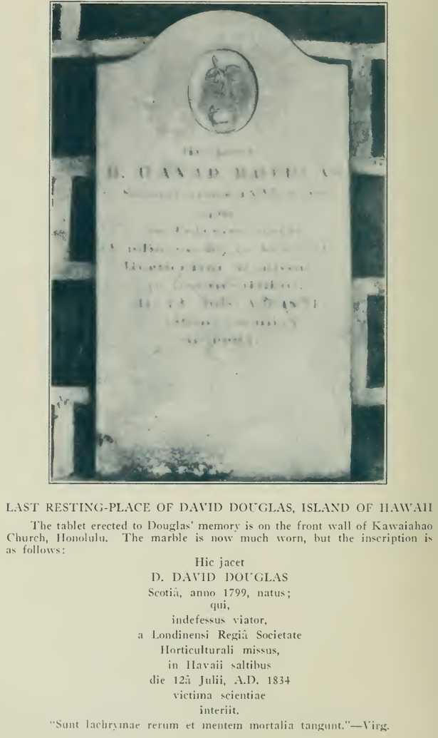
David Douglas was born
in 1793, and was in his twenty-eighth year when he crossed Athabaska
Pass. Men of his day wrote more light-heartedly about alpine regions
than we do now; moderate exaggerations were not then considered so
sinful. So it is extremely probable that Mount Brown and Mount Hooker,
and their altitudes, did not weigh too heavily on his conscience. What
we should remember is that Douglas was one of our greatest and most
successful exploring botanists, and that his sad and tragic death in the
Sandwich Islands, in 1834, brought to a close a career of immense
promise. His journals, although puzzling in their details, have been a
factor of no little importance to the incidence of Canadian
mountaineering; his story of the wonders of Athabaska Pass altogether an
influence for good. If we attempt to judge Douglas after nearly a
century, we can perhaps do no better than to accept his own words,
written at Fort Vancouver on New Year’s Day, 1826: “I can die satisfied
with myself. I never have given cause for remonstrance or pain to an
individual on earth.” |