|
(Explorations of the fur-traders. 1811-1827)
“For a long time yet,
a few suggestive
words grappling with things seen will have the advantage over a long
array of precise, no doubt interesting,
and even
profitable figures. The earth is a stage, and though it may be an
advantage,
even to the right
comprehension of the play, to know its exact configuration,
it is always the
drama of human endeavor that will be the thing,
with a ruling
passion expressed by outward action marching perhaps blindly to success
or failure, which themselves are often indistinguishable from each other
at first ”
Joseph Conrad
Mountaineering in the Canadian Alps can truly be said to have had its
incidence through events which transpired in the territory now known as
Jasper Park.
When I was little; when you were a school-child, geography-books taught
that the highest mountains of North America—Mt. Brown and Mt.
Hooker—lifted their unsurpassed heights on either side of Athabaska
Pass. You can still find these tremendous peaks, preserved in many a
modem atlas; they have become a tradition among map-makers. In those
school-days, of not so long ago, I had never seen anything higher than a
city office-building; but the gargoyles and cornices, seen through the
smoke and dust of street-canyons, seemed so impossibly high that the
very thought of mountains loftier was incomprehensible. My curiosity was
aroused; more often than anyone knew, I would prop up that battered
geography on my knees, and wonder at the sky-soaring propensities of
those far-away mountains.
Even the light of later years—the knowledge that the supposed elevations
are but mythical—has not robbed the old legend of its pristine charm.
Best of all, a kind fortune has let me visit the gateway itself, between
the basins of the Athabaska and Columbia Rivers; and there was nothing
of disappointment. It was a journey of expectations exceeded a
thousandfold.
But
aside from the legendary heights, Athabaska Pass acquired considerable
historic interest because of its importance as a trans-Canadian route in
the days of the fur-trade.1 Many descriptions of it are found
in the journals of the early
voyageurs;
and its story is a romantic one, furnishing us with a unique record of
na'ive impressions of mountain travel in the Nineteenth Century—upon
people who, save on their one crossing of the Great Divide, never before
nor after came in contact with alpine regions. It is not uninteresting,
therefore, to see the mental reactions of these wanderers toward great
natural phenomena whose magnitude and meaning they could but dimly
understand and grasp. The natural result, of course, was an exaggeration
of expression; but much of it entertaining and altogether charming.
Athabaska Pass was crossed by white men in 1811, when the party of David
Thompson, of the North-West Company, used it as a route to the Pacific
slope after hostile Piegan Indians had forbidden them the use of Howse
Pass. The route had been found before this, for Alexander Henry speaks
of it as a “route by which a party of Nepisangues (Nippisings) and
freemen passed a few years ago.” It is at least certain that the Pass
and the Canoe River region had been visited earlier by both Iroquois and
Nippising Indians.
Crossing the pass westward in January, 1811, David Thompson writes, “One
of my men Du Nord beat a dog to death. He is what we call a ‘flash’ man,
and a showy fellow before the women, but a coward at heart, and would
willingly desert if he had courage to go alone; very gluttonous and
requires full ten pounds of meat each day. As I am constantly ahead I
cannot prevent his dog-flogging and beating. We saw no tracks of
animals.
“The snow is full seven feet deep, tho’ firm and wet; yet the dogs often
sunk into it, but our snow-shoes did not sink more than three inches,
and the weather so mild that the snow is dropping from the trees and
everything wet. Here the men finished the last of the fresh and
half-dried meat, which I find to be eight pounds for each man per day.
“The view now before us was an ascent of deep snow, in all appearances
to the height of land between the Atlantic and Pacific Oceans. It was to
me a most exhilarating sight, but to my uneducated men a dreadful sight.
They had no scientific object in view—their feelings were of the place
they were. Our guide Thomas told us, that although we could barely find
wood to make a fire, we must now provide wood to pass the following
night on the height of the defile we were in, and which we had to
follow. My men were the most hardy that could be picked out of a hundred
brave, hardy men; but the scene of desolation before us was dreadful,
and I knew it. A heavy gale of wind, much more a mountain storm would
have buried us beneath it; but, thank God, the weather was fine. We had
to cut wood such as it was, and each took a little on his sled; yet such
was the despondency of the men, aided by the coward Du Nord, sitting
down at every half mile, that when night came we had only wood to make a
bottom and on this to lay wherewith to make a small fire—which soon
burnt out, and in this exposed situation we passed the rest of a long
night without fire. And part of my men had strong feelings of personal
insecurity. On our right, about one-third of a mile from us lay an
enormous glacier, the eastern face of which, quite steep, about two
thousand feet in height, was of a clean fine green color, which I much
admired; but whatever the appearance, my opinion was that the whole was
not solid ice, but formed from rills of water frozen in their course.
Westward of this steep face, we could see the glacier with its patches
of snow in a gentle slope for about two miles. Eastward of this glacier
and near to us, was a high steep wall of rock. At the foot of this, with
a fine south exposure had grown a little forest of pines, of about five
hundred yards in length by one hundred yards in breadth. By some
avalanche they had all been cut clean off as with a scythe; not one of
the trees appeared to be an inch higher than the others. My men were not
at their ease, yet when night came they admired the brilliancy of the
stars; and as one of them said, he thought he could almost touch them
with his hand.
“As
usual, when the fire was made, I set off to examine the country before
us, and found we had now to descend the west side of the mountains. I
returned and found part of my men with a pole of twenty feet in length,
boring the snow to find the bottom. I told them that while we had good
snow-shoes it was no matter to us whether the snow was ten or one
hundred feet deep. On looking down into the hole they had bored, I was
surprised to see the color of the sides of a beautiful blue; the surface
was of a very light color, but as it descended the color became more
deep, and at the lowest point was of a blue, almost black.
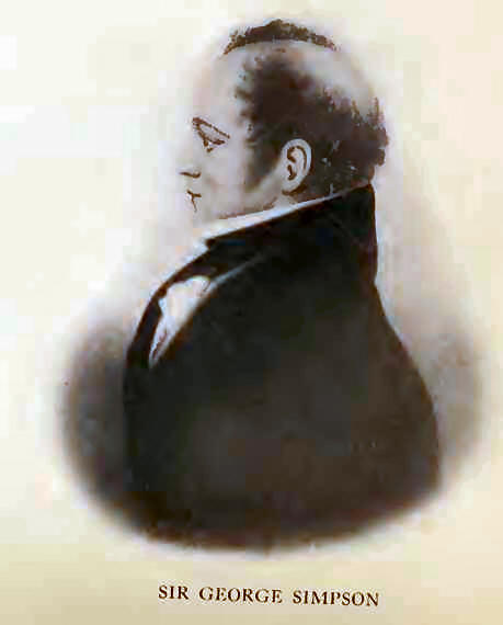
“The altitude of this place above the level of the ocean, by the point
of boiling water is computed to be eleven thousand feet (Sir George
Simpson).
“Many reflections came to my mind: a new world was in a manner before
me, and my object was to be at the Pacific Ocean before the month of
August. How were we to find provisions, and how many men would remain
with me, for they were dispirited? Amidst various thoughts I fell asleep
on my bed of snow.
“I
sent the men to collect and bring forward the goods left on the way,
which they brought except five pounds of ball, which being in a leather
bag was carried away by a wolverene.”5
Gabriel Franchere was a French-Canadian who had enlisted as clerk in the
Pacific Fur Company, had rounded the Horn in the “Tonquin,” and largely
assisted in the establishment of Astor’s post at the mouth of the
Columbia. In his journal1 he
recounts the arrival of Thompson’s canoes: “A well-dressed man, who
appeared to be the commander, was the first to leap ashore, and
addressing us without ceremony, said that he was David Thompson, and
that he was one of the partners of the North-West Company. We invited
him to our quarters, which were at one end of the warehouse, the
dwelling-house being not yet completed. After the usual civilities had
been extended to our visitor, Mr. Thompson said that he had crossed the
continent during the preceding season; but that the desertion of a
portion of his men had compelled him to winter at the base of the Rocky
Mountains, at the headwaters of the Columbia.
“Mr. Thompson kept a regular journal, and travelled, I thought, more
like a geographer than a fur-trader. He was provided with a sextant,
chronometer and barometer, and during a week’s sojourn which he made at
our place, had an opportunity to make several observations.”
William Henry followed Thompson across the pass, later in 1811, bringing
supplies. In 1812, Thompson himself returned eastward.
At
the onset of the War of 1812, with the selling out of the Astoria post
to the British, a number of men, unwilling to continue in service,
travelled eastward, at various times, crossing the mountains by
Athabaska Pass.
Franchere came eastward in 1814: “We quitted Fort George (or Astoria, if
you please), the 4th of April, 1814, in ten canoes, five of which were
of bark and five of cedar-wood, carrying each seven men as crew, and two
passengers, in all ninety persons and all well armed.
“We
ascended Canoe River to the point where it ceases to be navigable, and
encamped in the same place where Mr. Thompson wintered in 1810-11.
“On
the 12th of May we began our foot march to the mountains, being now
twenty-four in number, rank and file. Fatigue obliged us to camp early.
On the 13th we pursued our journey, and entered into the valleys between
the mountains, where there lay not less than four or five feet of snow.
We were obliged to ford the river ten or a dozen times in the course of
the day, sometimes with the water up to our necks. These frequent
fordings were rendered necessary by abrupt and steep rocks or bluffs,
which it was impossible to get over without plunging into the wood for a
great distance. The stream being very swift, and rushing over a bed of
stones, one of the men fell and lost a sack containing our last piece of
salt pork, which we were preserving as a most precious treasure. The
circumstances in which we found ourselves made us regard this as a most
unfortunate accident. We encamped that night at the foot of a steep
mountain, and sent on Mr. Pillet and the guide, M’Kay, to hasten a
supply of provisions to meet us.”
Mr.
Pillet must have been an interesting character, for Ross Cox has
preserved the details of the following amusing incident: “Mr. Pillet
(clerk at the Astoria post) fought a duel with Mr. Montour of the
Northwest, with pocket pistols, at six paces; both hits —one in the
collar of the coat, and the other in the leg of the trousers. Two of
their men acted as seconds, and the tailor speedily healed their
wounds.” Evidently western marksmanship had not yet come into its own!
Franchere continues his narrative: “On the morning of the 14th we began
to climb the mountain which lay before us. We were obliged to stop every
moment to take breath, so steep was the ascent. Happily it had frozen
hard the night before, and the crust of the snow was sufficient to bear
us. After two or three hours of incredible exertions and fatigues, we
arrived at the
plateau or summit, and followed the
foot-prints of those who had preceded us. This mountain is placed
between two others a great deal more elevated, compared with which it is
but a hill, and of which, indeed, it is only, as it were, the valley.
“Our march soon became fatiguing, on account of the depth of the snow,
which, softened by the rays of the sun, could no longer bear us as in
the morning. We were obliged to follow exactly the traces of those who
had preceded us, and to plunge our legs up to the knees in the holes
they had made, so that it was as if we had put on and taken off, at
every step, a very large pair of boots. At last we arrived at a good
hard bottom, and a clear space, which our guide said was a little lake
frozen over, and here we stopped for the night. This lake, or rather
these lakes (for there are two) are situated in the midst of a valley or
cup
of the mountains. On either side were immense glaciers, or ice-bound
rocks, on which the rays of the setting sun reflected in the most
beautiful prismatic colors. One of these peaks was like a fortress of
rock; it rose perpendicularly some fifteen or eighteen hundred feet
above the level of the lakes, and had the summit covered with ice. Mr.
J. Henry, who first discovered the pass, gave this extraordinary rock
the name of M’Gillivray’s Rock, in honor of one of the partners of the
N. W. Company.
“The lakes themselves are not much over three or four hundred yards in
circuit, and not over two hundred yards apart. Canoe River, which, as we
have already seen, flows to the west, and falls into the Columbia, takes
its rise in one of them; while the other gives birth to one of the
branches of the
Athabasca, which runs first eastward, then
northward, and which, after its junction with the
Unjighah,
north of the Lake of the Mountains, takes the name of
Slave
river,7 as far as the lake of that name, and afterward that
of
Mackenzie, in the journal of his voyages, states: “ . . . we came to the
Peace Point; from which, according to the report of my interpreter, the
river derives its name. . . . When this country was formerly invaded by
the Knisteneaux, they found the Beaver Indians inhabiting the land about
Portage la Roche; and the adjoining tribe were those whom they called
the slaves. They drove both these tribes before them; when the latter
proceeded down the river from the Lake of the Hills, in consequence, of
which that part of it obtains the name of the Slave River. The former
proceeded up the river; and when the Knisteneaux made peace with them,
this place was settled to be the boundary.”
This is surprisingly accurate geography for 1814, and shows how much
Mackenzie and Thompson had advanced the topographical knowledge of the
Northwest.
Franchere continues: “Having cut a large pile of wood, and having, by
tedious labor for nearly an hour, got through the ice to the clear water
of the lake on which we were encamped, we supped frugally on pounded
maize, arranged our bivouac, and passed a pretty good night, though it
was bitterly cold. The most common wood of the locality was cedar and
stunted pine. The heat of our bodies made the snow melt, and by morning
the embers had reached the solid ice: the depth from the snow surface
was about five feet. On the 15th, we continued our route, and soon began
to descend the mountain.”
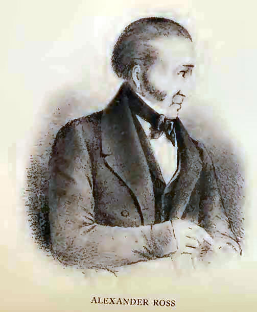
A
party, whose course was attended with disaster, was that of Ross Cox. He
had reached Astoria, as clerk on Astor’s second ship, the “Beaver,” and
came overland, in 1817, with a large company under his charge. Because
of illness and accident, seven men were sent back on reaching the mouth
of Canoe River. A capsizing canoe carried with it all their provisions,
and, with one exception, these unfortunates perished of starvation.
Cox
records the journey as follows: “Our baggage and provisions were divided
between the nine remaining men, who in consequence of the number we had
sent back, were obliged to carry about ninety pounds weight each,
besides their own kits, which in such cases are never taken into
consideration.
“Canoe River, which here joins the Columbia, is one of its principal
sources. In the dry season, it is broad, but very shallow, and near its
entrance spreads over several sandy shoals.
“On
the morning of the 28th of May, at ten o’clock we set off on foot along
the banks of Canoe River, which winds its way through a wide and
cheerless valley. We had not proceeded far when we found it impossible,
from the great rise of the water, to pass the ordinary fords. It
appeared like a lake, and completely set at naught the topographical
knowledge of our guide. This obliged us to strike into the woods, our
progress through which was extremely fatiguing, and at three
P. M. we bivouacked about
two miles beyond a long woody point, which stretches some distance
across the valley. The weather was cloudy all day, with slight showers,
which during the night increased to heavy rain, from which we had no
shelter.
“We
proceeded on, and about noon, May 30th, encamped within a short distance
of the grande
cote, or principal hill which we have to
ascend in passing from the Columbia. The weather was charming all day.
“Shortly after dawn on the morning of the 31st we commenced the ascent
of the first great hill. At its base were cedar and pine trees of
enormous magnitude; but, in proportion as we ascended, they decreased in
size, and at the summit of the hill their appearance was quite dwarfish.
We completed the ascent in about four hours and a half, and did not find
it so difficult as we had anticipated. This however may be attributed to
our having commenced the task early in the morning.
“A
short time before we reached the summit, and from thence to the level of
the table land, our progress lay through a wilderness of deep snow,
which we had to beat down to form a pathway for the loaded men. This
work, owing to the holes into which several of the party occasionally
fell, was both fatiguing and dangerous.
“At
one P. M.
we arrived at two small lakes, between which we
encamped. They are only a few hundred feet each in circumference, and
the distance between them does not exceed twenty-five or thirty feet.
They lie on the most level part of the height of land, and are situated
between an immense cut of the Rocky Mountains. From them two rivers take
their rise, which pursue different courses, and fall into separate
oceans; the first winds into the valley which we had lately left, and,
after joining the upper part of the Columbia, empties itself into the
North Pacific; while the other, called the Rocky Mountain River, a
branch of the
Athabaska, follows first an eastern and then
a northern course, until it forms a junction with the
Unjigah
or Peace River. This falls into Great Slave Lake, the waters of which
are ultimately carried by M’Kenzie’s River to the Arctic Ocean.
“The country around our encampment presented the wildest and most
terrific appearance of desolation that can be well imagined. The sun
shining on a range of stupendous glaciers, threw a chilling brightness
over the chaotic mass of rocks, ice, and snow, by which we were
surrounded. Close to our encampment one gigantic mountain of conical
form towered majestically into the clouds far above the others (This is
called M’Gillivray’s Rock, in honour of the late Mr. William M’Gillivray,
a principal director of the Company), while at intervals the interest of
the scene was heightened by the rumbling of a descending
avalanche;
which, after being detached from its bed of
centuries, increased in bulk in its headlong career downwards, until it
burst with a frightful crash, more resembling the explosion of a
magazine than the dispersion of a mass of snow.”
Then follows that delightful classic paragraph: “One of our roughspun,
unsophisticated Canadians, after gazing upwards for some time in silent
wonder, exclaimed with much vehemence, ‘I’ll take my oath, dear friends,
that God Almighty never made such a place!"
In
1825, four years after the merging of the NorthWest and Hudson’s Bay
Companies, Alexander Ross, with the young Governor, George Simpson,
crossed the pass, eastward bound. Ross9 gives us an
entertaining and graphic picture of the scene: “Turning around to the
east [from Boat Encampment on the Columbia River], the view is abruptly
checked by the mountains, not in continuous ranges, but heights rising
above one another, almost everywhere shrouded in a dark haze, which
renders a passage over them extremely doubtful. Yet through the
apparently inaccessible barrier the traveller has to make his way.
“The Governor himself, generally at the head, made the first plunge into
the river, and was not the last to get out. His smile encouraged others,
and his example checked murmuring.” Here, in a sentence, is the epitome
of leadership!
The
narrative continues: “Although we were now on the top of the Grande
Cote, or Bell Hill, let not the reader imagine we had reached the
highest part of the Rocky Mountains; for we saw heights towering above
heights, until their distant summits were lost in the clouds. On the
summit of the Grande Cote we found the snow eight feet deep, and there
we encamped for the night.
“Leaving now the Grand Cote we advanced on the morning crust at a quick
pace, through a broad level valley, thickly wooded with dwarf pines, for
about six miles in an easterly direction, when we reached what is called
the great height of land. At this place there is a small circular basin
of water, twenty yards in diameter, dignified with the name of a lake,
out of which flow two small creeks. The one on the west side discharges
itself into Portage River; that on the east joins the Athabaska River at
a place called the Hole.”
Then follows an explanation of a historic nomenclature: “This elevated
pond is further dignified with the name of the ‘Committee Punch Bowl,’
in honour of which his Excellency treated us to a bottle of wine, as we
had neither time nor convenience to make a
bowl of punch, although a glass of it would have been very acceptable.
It is a tribute always paid to this place when a nabob of the fur-trade
passes by.”
In
October, 1826, Thomas Drummond, Assistant Naturalist to the Second
Franklin Expedition, who had spent the year in the vicinity of Jasper
House, made a journey across Athabaska Pass to Boat Encampment, on the
Columbia Loop, and return.
He
records that “at about fifteen or twenty miles above the commencement of
the Portage, we left the main branch of the Red Deer River, and followed
a lesser stream that here joins it, winding along its banks, and not
infrequently scrambling in the bed of it, until we reached a small lake,
and the Height of Land. The lake is not more than two hundred yards in
length, and is called the
Committee’s Punch Bowl.
Out of its other extremity flows one of the tributary streams of the
Columbia.
“On
reaching the middle, I took a hearty draft, pleasing myself with the
thought that some of the water I had tasted might have flowed either
into the Frozen or Pacific Oceans.”
He
adds, almost in afterthought: “The first glacier I saw was about twenty
miles before reaching the lake; but I visited a very large one ten miles
nearer the lake.” This, as we shall see later, is the splendid icefall
of Scott Glacier, a chief source of Whirlpool River.
“Sketch of a Journey to the Rocky Mountains and to the Columbia River in
North America,”
Thomas Drummond,
Assistant Naturalist to the Second Land
Arctic Exploring Expedition, under the command of Captain Sir John
Franklin, R. N., in Hooker’s
Botanical Miscellany,
Vol. I, pp. 178-219.
Drummond reached the Boat Encampment on October 17th, and returned
thence with Finan M’Donald to Jasper House, arriving on the 30th.
No
man perhaps better exemplifies the fine type of many employed by the
Hudson’s Bay Company than Edward Ermatinger. The son of Lawrence Edward
Ermatinger, Assistant Commissary General, he was born on the Island of
Elba, off the west coast of Italy, in February, 1797. Something of a
genius, he attained fluency in the Latin, Italian, and French languages,
and became a proficient musician, playing the flute and the
violin—talents which were not unuseful in the later times of lonely
winters in the trading posts. Being taken to Canada, he served with the
Hudson’s Bay Company from 1818 until 1828, eventually settling in St.
Thomas, Ontario, where he became merchant, banker, and postmaster.
In
his journal, Ermatinger has recorded three crossings of Athabaska Pass:
business-like accounts with but little description of natural
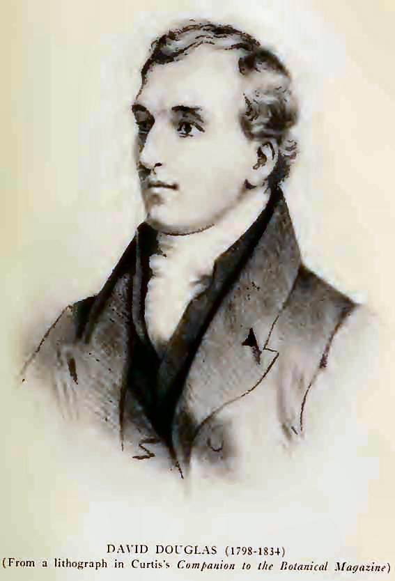
surroundings. On the first crossing, in 1827, the botanist David Douglas
—of whom more will be said—accompanied him:
“March 20th; fair weather. The Express boat leaves Vancouver [Fort
Vancouver, seven miles north of the present city of Portland, Oregon. In
1846, it was the largest Post of the Hudson’s Bay Company] at a quarter
before six o’clock. A second boat accompanies us as far as the Chutes to
assist in carrying over them, and to strengthen the party. Passengers
Messrs. McLoughlin, McLeod, Pambrun, Annace, Douglas, and E. Ermatinger.
“April 28th. Two of our Iroquois who would not have carried snow-shoes
from the Boat Encampment, had I not insisted upon their having them, now
found them very useful and were glad to put them on. A wolverene hovers
about our camp. Mr. Douglas wounds him, but he escapes.
“Monday, 30th. Arrive at the foot of the Grande Cote at eight o’clock.
Ascend it for two miles and encamp at eleven a. m. Experienced some
difficulty in finding the proper track.
“Tuesday, 1st. Fine weather. Start at half-past four a. m. Snow not less
than between four and five feet deep. Continue to ascend the Grande Cote
by very short stages for about two miles till we meet the Rocky Hills on
the right at eight a. m. when we incline a little to the left and having
journeyed I should say between three and four miles, encamp nearly a
mile on this side of the height of land at noon. We experienced again
much difficulty in finding and keeping our road. In fact we could not
ascend fifty yards before the people were wandering in every direction
in search of the track. What few marks have been made to point out the
way I conceive are concealed by the depth of snow. Kill a partridge.
“Fine weather. Resume our journey at three a. m. in order to avail
ourselves of the crust on the snow. Course northeast. Travel at a good
pace for about seventeen miles and stop at eleven a. m. to breakfast and
give the people a rest during the heat of the day.”
Leading the York Factory Brigade, westbound, in the autumn of the same
year, he writes: “Started at eight a. m. and encamped near the height of
land, having passed through some very bad swamps and mires during the
day. View of the mountains very grand. The road was never better; we had
not the least snow on the way. Apisasis killed a young grizzly bear at
the height of land, and one of the men killed a martin on the Big Hill.”
In
May, 1828, Ermatinger was again eastward bound. He tells us there was
but little snow on the Big Hill and no necessity for using snow-shoes.
“Found little snow until we get halfway up the Hill. Take breakfast at
the top of the Hill between nine and ten—resume at noon and proceed to
within four miles of the Height of Land and encamp at half-past three p.
m.
“Rained and snowed during the whole of last night —day fine but cold.
Start at half past four a. m. Pass the height of land at six. Proceed on
deep snow near to Campement de fusil. Take breakfast. Afterwards snow
diminishes fast.”
A
journey across Athabaska Pass was, in those days, a serious undertaking;
fur-traders could not be expected to keep extensive journals, still less
to waste time in admiration of scenic beauty. But what a pity Ermatinger
could not have told us a little more about David Douglas and his
scramblings at the pass summit!
The
young Scots botanist, who came eastward with Ermatinger, in 1827, is
remembered because the Douglas fir
(Pseudotugia Douglasii)
bears his name, and because he named Mounts Brown and Hooker.
Let
us first see what Douglas has to say regarding the pass itself. In his
detailed diary,3 kept while on the
trail, he tells us, “In the grey of the morning we resumed our route on
snow-shoes in the wood about three-quarters of a mile. Entered a second
valley, course northeast. Rested after having travelled two and a
quarter miles, in the course of which we made seven fordings over the
same river that we had crossed yesterday. Continued in the same course
for the distance of four miles more until reaching the east end, making
four fordings more. Here the stream divides into two branches, that on
the left flowing from the north, that on the right due east. Took our
course in the angle between the two, northeast, entering a thick wood of
the same kinds of timber already noticed.
Pinus balsamea
more abundant and of greater size. After passing a half mile in the
wood, reached the foot of what is called the
Big Hill,
also thickly wooded. Steep and very fatiguing to ascend, the snow four
to six feet deep in the higher spots. The ravines or gullies
immeasurable and towards noon becoming soft, sinking, ascending two
steps and sometimes sliding back three, the snow-shoes twisting and
throwing the weary traveller down (and I speak as I feel), so feeble
that lie I must among the snow, like a broken-down waggon-horse
entangled in his harnessing, weltering to rescue myself.
“No
water—melted snow, which makes good tea; find no fault with the food,
glad of anything. The remainder of the day is spent as follows: On
arriving at a camp, one gathers a few dry twigs and makes fire, two or
three procuring fuel for the night, and as many more gathering green
soft branches of
Pinus balsamea or
canadensis
to sleep on, termed ‘flooring the house,5 each hanging up his
wet clothing to the fire, repairing snow-shoes, and arranging his load
for the ensuing day, that no time may be lost. In the morning, rise,
shake the blanket, tie it on the top, and then try who is to be at the
next stage first. Dreamed last night of being in Regent Street, London!
Yet far distant. Progress nine miles.”
The
graphic description continues: “This morning our fire that was kindled
on the snow had sunk into a hole six feet deep, making a natural
kitchen. Started at daybreak, finding the snow deeper and gradually
diminish toward the summit; laborious to ascend. Went frequently off the
path in consequence of not seeing the marks on the trees, being covered
with the snow. Reached the top at ten, three miles, where we made a
short stay to rest. Course northeast. Descended in the same direction
and came on the river which we left two days before. Passed in the
valley two small level spots clear of wood, and one low point of wood
with small trees, where we camped at midday, being unable to proceed
further from the soft deep snow. Progress seven miles.
“My
ankles and knees pained me so much from exertion that my sleep was short
and interrupted. Rose at three a. m. and had fire kindled. Started at
quarter past four through a gradually rising point of wood which
terminated three hundred yards below the highest part of the pass in the
valley. An hour’s walk took us to one of the head springs of the
Columbia, a small lake or basin twenty yards in diameter, half flowing
into the Pacific and half into the hyperborean sea—namely the headwaters
of the Athabaska River. A small lake, about 47° of North latitude,
divides its waters between the Columbia and one of the branches of the
Missamac, which is singular. This being a halfway house, or stage, I
willingly quickened my pace, now descending on the east side. This
little river in the course of a few miles assumes a considerable size
and is very varied.
“There are two passes, one four miles from its source and one seven,
when it finds its way over cascades, confined falls, and cauldrons of
fine white and blue limestone and columns of basalt, like the feeders of
the Columbia at the deep passes of the mountain; where the torrents
descend with furious rapidity, it spreads out into a broad channel
bounded by the mountains. The descent from the east is much greater than
from the west, the mountain more abrupt and equally rugged. Found the
snow eight miles below the ridge gradually diminish. The heat increases
and the quantity of snow on the east not equal to the west. Passed on
the right a very high (perhaps 4000 feet), perpendicular rock with a
flat top, and three miles lower down on the same two higher ones, rising
to peaks about a mile apart at the base with a high background which
appears two-thirds glacier, and in the valley or bosom of the three,
columns and pinnacles of ice running out in all the ramifications of the
Corinthian order.”
In
a condensed journal, written some time after the actual events, there
may be found a further description of the pass. After leaving Boat
Encampment, Douglas informs us, “We crossed at the angle between the two
streams and commenced our ascent of the ‘Big Hill.’ The snow being so
deep, exceeding six feet, the footpath markings on the trees were
hidden, so that some difficulty was experienced in keeping the way; the
steep ascent, the deep gullies, and brushwood and fallen timber rendered
it laborious. Camped two miles up the hill, having gained in all nine
miles.
“We
continued our ascent, and at ten had the satisfaction to reach the
summit, where we made a short stoppage to rest ourselves, and then
descended the eastern side of the Big Hill to a small, round, open piece
of ground through which flowed the small or east feeder of the Columbia
and the same stream we left yesterday at the western base of the Big
Hill. Near this point we put up at midday.
“At
three o’clock I felt so cold, the thermometer stood at only 2° below
zero, that I was obliged to rise and enliven the fire and have myself
comfortably warmed before starting. Through three hundred yards of
gradually rising, open, low, pine wood we passed, and about the same
distance of open ground took us to the basin of this mighty river, a
small circular lake, twenty yards in diameter, in the centre of the
valley, with a
small outlet at the west end—namely one of the branches of the
Athabasca, which must be considered one of the tributaries of the
McKenzie River. This is not the only fact of
two opposite streams flowing from the same lake.
“This ‘The Committee’s Punchbowl,’ is considered the halfway house. We
were glad the more laborious and arduous part of the journey was done.
The little stream Athabasca, over which we conveniently stepped, soon
assumed a considerable size, and was dashed over cascades and formed
cauldrons of limestone and basalt seven miles below the pass; like the
tributaries of the Columbia on the west side, the Athabasca widens to a
narrow lake and has a much greater descent than the Columbia.”
In
his journals David Douglas describes his ascent of a peak close to
Athabaska Pass, and the naming of Mounts Brown and Hooker. The
over-estimated altitudes, together with the opinions of contemporaneous
writers regarding the elevation of the region, require further
consideration. |