|
“Starving men are
early risers.”
Gabriel Franchere
“They were awakened
by the severity of the cold, and there was no walking to procure
themselves warmth: the day was never so long in coming, and the night
seemed never to have an end. They set out again at day-break, as
benumbed as Marmotts, and it was some time before they could recover the
use of their limbs.”
Bourrit
Feeling that we had
made a satisfactory reconnaissance of the Athabaska Pass and its
surroundings, we returned down the Whirlpool, on July 2d, and camped
near the Scott Glacier, beside a shallow lake in the wooded moraine. It
was a day of travel when Nature seemed pleased to show us her valley
inhabitants—the soaring eagle that guards the rock of McGillivray; a
lonely startled duck skittering across the Punch Bowl; marmots playing
and boxing in sunny snow-patches beside the balsam trees. Flowers
everywhere: columbine and heather; Dave, our Indian, riding ahead with a
bright bouquet nodding from his hat.
A night of
thunder-storms; the morning of July 3d clearing slowly after a
threatening dawn. Such an electrical display and a pounding of thunder
there had been—crashing and reverberating. During the flashes, white
ghostly figures could be seen scurrying about, making the canvas secure.
Now and then one would hear a muffled clanking on the gravel, indicating
that the interior of a tent had been vacated by axes which might serve
as impromptu lightning-rods. We believe this to be not entirely
superstition; on the ridge of Mount Brown many pitted slabs of shale
were found, with square-cut holes where metallic crystals had been
cleanly destroyed by electrical agencies.
We made a late start,
at half-past nine, expecting only to prospect the Scott icefall for a
route to the upper basin. Our camp in the Whirlpool Valley was quite low
(4500 feet), and it was on this account that we had first investigated
the higher level of Athabaska Pass. We now had our tents within a
quarter-mile of the ice, and soon passed the huge isolated boulders of
the terminal debris and were on the flat tongue. The nearly level ice
can be traversed for about a mile, and the eastern moraine, below Mount
Scott, brings one almost to 7000 feet before it becomes necessary to
rope and take to the ice again.
The glacier plunges
down from the Hooker neve, at an elevation of 8000 feet, through the
portal between Mounts Scott and Evans, with a width of nearly a mile.
The fall is extremely broken, with gigantic seracs on the verge of
tumbling. A fragmentary medial moraine is formed through the erosion of
a buttress, partially exposed in the middle of the icefall, at which
level there is a lessening of the ice slope before the final drop to the
bulbous tongue.
From our roping place,
one ascends another thousand feet before reaching the Hooker Icefield in
the extensive basin between Evans, Hooker, Ermatinger, Oates, and Scott.
This entails a good deal of step-cutting and some careful icemanship; it
was half-past one before we were through. The basin is more than three
miles across, and from cols in its bounding ridges—the eastern and
southern are on the Continental Divide—other icefalls, all badly
shattered, pour in until the field presents a wild scene of unsupported
pinnacles and broken seracs over an extended area. A. L. Mumm who, with
the guide Inderbinen, visited the lower reaches of the glacier in 1913,
wrote of it, “We were in the centre of an immense battlemented cirque,
and straight ahead of us, in particular, stood out against the sky the
most menacing array of towers and pinnacles I have ever seen.” There is
very little in other Canadian icefields with which to compare it: one
thinks rather of the northern glaciers of Mont Blanc as they come down
from the Grand Plateau, but the Hooker Icefield gives an impression of
greater breadth and breakage.
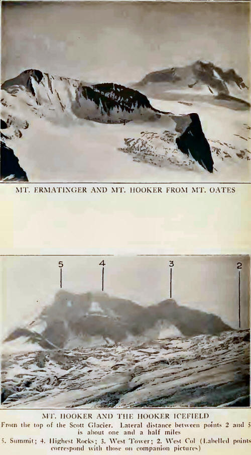
Turning eastward and
rounding the cliffs of Mount Scott, our way lay across a flat of snow,
toward a tumultuous waterfall, a broad gully of shale bringing us
quickly to an upper snow plateau between Mounts Scott, Oates, and
Ermatinger. It was a quarter past two.
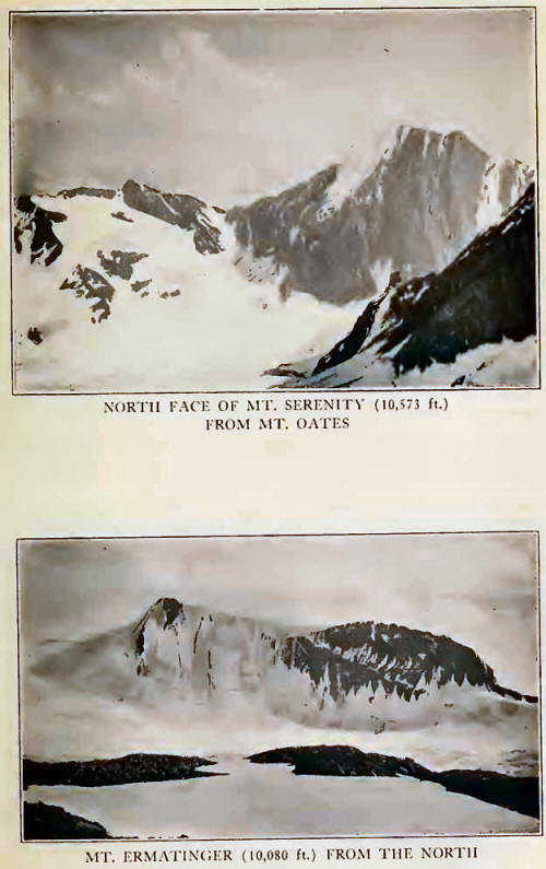
Mount Ermatinger is a
mountain of inspiring beauty: a long, knife-edged arete, rising from the
Hooker Icefield in a jagged crest of uptilted rock strata, continuing
into the north face and merging with a sheer, fluted wall of shining,
green ice. The ice-wall is nearly a thousand feet high, broad and
unbroken; in our combined experience we could think of but few so
glorious. More than anything else it suggested the oncoming mass of a
curling sea-wave, about to break and with the sunlight in its crest. Had
time and weather permitted it would have been ours within a few days,
the difficulties being easily avoidable. We passed it by with regret,
envying those who will first stand on its lovely heights.
We had still the
opportunity of making a climb and it was necessary to decide upon the
most accessible peak. We had been heading for what seemed to be the
highest of the group, believing it to be Mount
Scott. The peak
adjoining Ermatinger on the north we took to be Mount Oates; but on
closer examination of the ground we saw that this is a lower, unnamed
summit—which will give someone an enjoyably strenuous climb—and that the
peak we were approaching was really Mount Oates itself. We climbed to a
little col overlooking the South Alnus Glacier and followed up the ever
steepening shale and rock to the summit (10,220 feet). On the last
thousand feet the rope was discarded.
Not far away, and only
six hundred feet above us, were the shale-tops of Mount Scott, with a
lengthy talus slope of moderate angle running down to the snow plateau.
We had been told that the mountain would afford good rock-work, but from
this side it looks monotonously easy. Our own peak was immensely
preferable. The only way to climb Scott, with pleasure, will be by its
western wall.
Although it was 5.45 P.
M., we settled down to enjoy our surroundings. Below us, on the north,
there was a profound drop to the North Alnus Glacier, while down Alnus
Creek the waters of Fortress Lake were completely in view. Alberta, The
Twins, and Columbia limit the southeastern horizon, and one might trace
the Divide around the head of the Chaba icefields, across Fortress Pass,
up to the acute angle at Divergence Peak; and back again to the
conquered peak where some of us—not all—were hard at work
cairn-building. Thence southward goes the watershed, around the Hooker
basin and the subsiding ridges, shimmering in the saffron light of
evening, that carry it to Athabaska Pass. And beyond Mount
Ermatinger—we were
always looking back—the majestic northern walls of Serenity, its lower
slopes in the long shadows that fill the valley of Fortress Lake and the
head of Wood River.
The return was a race
with daylight. It took us only an hour to return to the top of the
seracs (7.15 P. M.), and two hours more to go down through the intricate
labyrinth. We were soon off the upper ice, and, thanking all natural
forces for the long twilight of northland July, made camp at half-past
ten, just as darkness became annoying. We are convinced that, in most
instances, approaching darkness is tantalizing in inverse ratio to the
distance from the frying-pan! On the upper snows it doesn’t matter so
much; in the last uncertain scrambling in the moraine and glacial brook
it brings out profanity.
July 4th was a day of
rest in camp. The National Holiday was celebrated with spasmodic efforts
at bathing and laundry, and in the futile attempts to construct
steam-bombs out of jam tins. Conrad was the object of much photographic
activity; all the horses of the pack-train followed him into the pond—we
had been out from Jasper for more than a week and there was a lot of
salt on his hide!
Next day, July 5th, an
ascent was begun which eventually took more time than we had expected.
In fact it turned out to be something of an endurance record for a
Canadian climb—a record that we have since been told we are quite
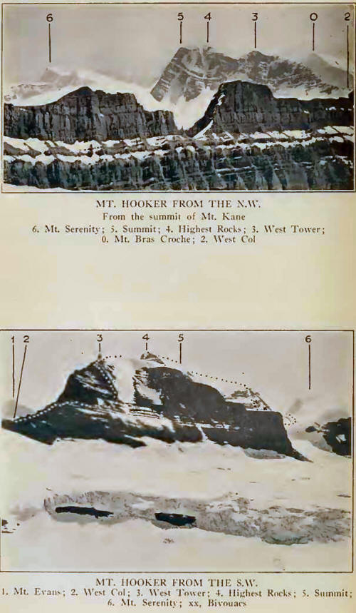
welcome to. We started for Mount Hooker at a quarter before five, taking
forty-five minutes to the ice and an equal time to the rocks at the foot
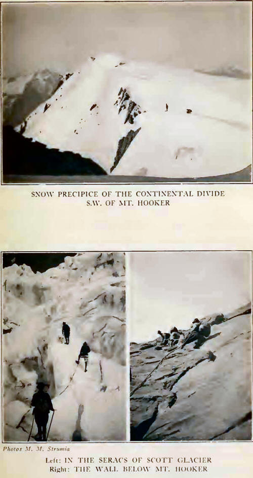
of the west wall of the glacier. In selecting the wall, below Mount
Evans, it had been hoped to establish a quicker approach to the upper
snows than had been found in the ice route to Oates. Further, the rocks
offered a more direct route to the mountain. It proved not to be so
short.
Two twenty-foot
chimneys were followed by ascending ledges and slabs, and consumed an
hour. We traversed southward and upward across a slanting watercourse
and crossed below a large waterfall in the center of the wall. By
re-entering this gully it seemed possible to ascend directly by broken
ledges. We had barely started when a whizzing, and Conrad’s cry of “Stonefalls!”
made us take to what cover was available. It was the beginning of a
raking fire in which we were all struck, but luckily without damage.
Conrad, calmly saying “Gentlemen, we must move a little to one side,”
relieved the tension; we quickly got out of range, in time to avoid a
heavy bombardment of larger boulders that came banging down over our
intended path and would surely have done for us had we persisted. We
realized afterward that in Conrad’s cool leadership, in emergency, we
had seen one of the finest things produced by mountaineering art.'
So, selecting a new
way, we went on; the ground became increasingly difficult; in one narrow
chimney of thirty-five feet the axes and sacks had to be roped up, and
the last man, looking up at a wrong moment, got the returning coils full
in the face and rather to the detriment of a treasured incisor. Above
the chimney was a low bulge of exposed cliff and the two formed a little
section on which an hour was spent. Easier ledges brought us up to the
glacier and we saw that the ice route would after all have been
decidedly preferable.
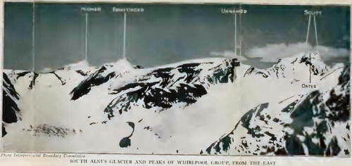

It was eleven o’clock,
and we halted twenty minutes for second breakfast. Mount Hooker was now
in front of us, across an extent of threatening seracs, with northern
cliffs surmounted by a twisted, corniced arete that makes direct ascent
impracticable. The eastern end of the mountain swoops down in a fearful
ice-bulge that seems to overhang, and, even from Mount Oates we had not
seen a plausible way up. And so we chose the western col, knowing it
might give us a long fight; yet we had seen this side from the Kane
Icefield and had found nothing better.
Crossing, not without
some windings through the crevasses, we reached a poorly bridged schrund,
and thence cut forty-five ice-steps to the col. We were at 9300 feet;
the delay was an unexpected one, and it had taken us from 1.45 until
2.30 P. M. to cross the schrund and reach the saddle. The sharp buttress
and tower rising from the col to the west arete were avoided by
traversing and ascending ledges on the south face, above the glaciers
draining to Wood River. Steepening pitches of no great difficulty, close
to the margin of a broad snow-gully, brought us to the mountain’s crest
below the rocky tower near the junction of the middle and western thirds
of the summit arete. It was at this point that I was taking advantage of
some awkward attitudes on the jutting rock, to take a picture of those
ahead of me. But the handling of the rope requires first attention, and
in caring for this a coil touched the open camera. Over it went, rolling
a few feet on the shale and dropping out of sight. It must have fallen
nearly two hundred feet before striking; we looked over the edge and
finally located it. Conrad eventually recovered the splintered box, and
beyond our wildest expectations the lens, shutter, and bellows were
intact. The roll-film had not been thrown out, and, although the picture
last exposed was ruined, the film eventually produced ten perfect
negatives out of twelve exposures. All which is recorded as evidencing
that miracles still occur!
The top of the tower is
shaly, but we avoided it entirely and maintained our altitude by
crossing a broad snow-shoulder extending southward. Here was a really
bad schrund, with flat, thin bridges, and a cornice lip—all which we
treated with marked respect and crossed cautiously on all fours. We
adopted the slow motions of the breast-stroke to this particular
situation, in a way that would have delighted a swim-ming-instructor.
We now gained height on
the main arete, for the first time able to gaze over the northern wall.
We pushed on rapidly, the heavy, compact snow-crust requiring
superficial cutting, and pulled through some small chimneys to the
highest rocks at" half-past seven. From below, we had thought that these
last rock-towers might be the highest point, but, arriving, it was plain
that the snow-crest beyond culminated in two wavelike points, with the
eastern the higher. After making a tiny cairn and leaving a record, we
followed the cornice base to the steep snow of the highest point. It was
eight o’clock, and more than fifteen hours had elapsed since we left
camp. Had David Douglas been with us he might well have thought his
estimate of height was not so far wrong! We anchored, and each,
separately, had a look over the cornice down the north wall to the
icefield. Smoke had just begun to come in from a distant forest-fire in
the direction of Canoe River; we gazed back along the line of dripping,
curling cornices into a red sun—it was as if one were living in the
atmosphere of an early lithograph of “The Alps,” so gaudy it was. Our
more rational interest, however, during the few minutes on the actual
summit (10,782 feet), lay in the fact that we appeared to overtop Mount
Scott. We later confirmed this from Mount Fraser, in the Rampart Group,
and are almost convinced that Hooker is the loftiest peak of the group.1
We would not, however, be understood as placing our eyesight in
competition with the work of the Interprovincial Survey; so for the
present Mount Scott must remain supreme, at least so far as elevation is
concerned.
It was becoming late,
and there was quite evidently insufficient time for us to get off the
mountain and return by the way we had come. We had no desire
*A similar and
independent conclusion was arrived at by the first party to ascend Mount
Serenity. Mr. Carpe informs me that both Palmer and myself were very
much surprised when the survey map came out showing Scott to be higher
than Hooker. It definitely did not make that impression from Serenity. I
should say that it (Mount Scott) seemed lower than Serenity. On
subsequent examination of photographs taken from the Fraser Group the
previous year, however, Scott appears to hide Serenity. Owing to the
late hour at which we reached the top of Serenity, I did not take
instrumental levels on anything. I have no reason to question the
Boundary Commission’s figures.” to return down the rock-wall in the
dark, nor, for that matter, at any time. So we started down a long
snow-shoulder, direct from the peak and descending westward of the
snow-flats which form an irregular pass between Hooker and Serenity. As
we walked down, close to the edge, about sixty feet of cornice split off
and sank silently, its impact far below producing echoing crashes. We
came to the southern extremity of the shoulder without seeing any way
down until the terminal buttress was reached. Following down the margin
of a broad couloir for a little way without trouble, another six hundred
feet of ledges would have taken us to the glacier.
We stopped for a moment
to look at the sunset: the base of the Wood River massif half hidden in
violent mist; the sky tinged with the faint green of arctic twilight,
with a tracery of smoke wisps, grey and red; Clemenceau’s pyramid lifted
into the heavens, with no apparent foundation, a floating thing, serene,
above Bras Croche, with the pearl-pink colorings of an oriental mosque.
.
Perhaps we were
hypnotized; the weather was fine, the view entrancing; we had come down
to the respectable level of 9600 feet, and it was too late to get home.
We planned a night on the rocks. What more natural than when we saw a
perfectly fine cave close at hand, we should make for it? It was roomy
and dry, with doorway rather larger than one would have selected for a
permanent habitation; but altogether not to be sniffed at. There was a
trickle of water only a few feet away, so we consumed most of our
remaining provisions and thought little of it.
We spread our things
about, crawled near to each other, and for a while slept quite
comfortably. And then the trouble began. About midnight there were
flashes of lightning and a rumbling of thunder. Rain fell, soon turning
to snow. A wind came up, gusty and carrying snow into the cave. We were
fairly well protected and kept dry. We got up at four o’clock, with the
first signs of daylight, peering out to find a dense fog which obscured
everything more than fifty feet away. There was a light covering of snow
on the ground and the sleet continued.
Roping, we started
downward, thinking to reach the glacier, round eastward to the pass and
get over to the Scott icefall. We got down to the glacier margin without
much difficulty, although progress was slow and care was required where
the rocks had become icy. The fog was most deceptive and we had trouble
in distinguishing height and pitch of quite simple bits of cliff;
judgment was frequently at fault.
And here we stopped. We
had map and compass and knew our direction; but the Wood River slope of
the Hooker Icefield is so fearfully put together with different levels
of serac and twisted, insinuated buttress, that we simply could not
tell, in the fog, just where the Hooker-Serenity pass might lie. There
were several chances of going astray and wandering over farther on the
Wood River side; which, away from our base of supplies, might be
disastrous. We stamped around in the snow for two hours and attempted to
reach the pass by keeping close to the southern butt' resses of Mount
Hooker. The fog, contrary to expectation, did not break, and the snow
kept coming down.
We were making very
little headway, so at ten o’clock, finding a protected corner, walled in
on three sides and roofed over by a gigantic slab, we decided to wait
out the storm rather than waste energy in fruitless efforts. The wet
snow had soaked us; our food was gone except for some bits of chocolate
and cheese; we had but a little extra clothing, and no means of making
fire. We were at 9300 feet and the snow kept on throughout the day. We
arranged things as well as possible, flooring the cavern with flat
slabs, blocking the open side with boulders and filling the chinks with
snow. Fog hid everything but near objects. We were wet and cold,
beginning to get hungry. All suffered more or less with intermittent
cramps in the thigh and abdominal muscles.
There was a good deal
of shivering, that was hard to conceal, done that night; and quite a bit
of gastric burning, not so evident, but none the less painful— luckily
we could get water in the cave. We had no way of keeping out the fine
blown snow, although we sacrificed the warmth of one rucksack to stop
the largest hole in the wall.
Morning came, a
cheerless dawn, but we had been watching for it. The snow seemed to be
lessening; the fog ebbed and billowed. Just before four o’clock, the
snow ceased; the fog wavered and lifted, so that as we looked out we
could see the ground below us and the way to the pass. We were a stiff
lot, but Conrad made a leap for his boots that startled us. It is hard
work putting on half-frozen shoes, and our guide was first out, pushing
over the snow-crusted boulders in the doorway in his hurry. Miserably
uncomfortable as we were, it was impossible not to think of Samson and
the pillars of the Temple!
Conrad went ahead to
break trail; the ground was not difficult, once the way was seen, and
the rest of us roped and followed. For a few minutes, as we zigzagged
down to the glacier, we could see the lower slopes of Bras Croche, of
Ghost Mountain, across Wood River, and Chisel Peak on Fortress Lake. It
was only a few hundred feet down to the ice and, as we slowly followed
Conrad’s track, the fog closed down gradually. We found Conrad returning
with the good news that he had found the pass and had been nearly to it.
He roped with us and we proceeded as fast as we were able. It began to
snow and blow harder than ever; but we were sure of ourselves. Our faces
and clothing became coated with ice, and hands were cramped through
holding a frozen rope. For an instant we saw a dark stretch of open
water in the lakelet on the pass summit, and everything was hidden
again. The wind blew with great violence, making balance on level ground
an uncertain affair; our tracks were not very straight, but the slope
began to be downward, and we knew we had come across into territory that
was familiar. Through rifts in the mist we recognized the cliffs of
Ermatinger and the eastern ice-bulge of Hooker, and came at last out of
the storm to the main icefall.
The seracs were all
snow-covered; but we would have tackled worse things to get off the
mountain. Conrad’s never-failing craft brought us down in good order to
the unroping place, and we followed the route used for Mount Oates, down
the eastern moraine and the glacier-tongue. Camp was reached shortly
after eleven o’clock. It was July 7th, and we had been out a little more
than fifty-four hours.
Things had been
happening at camp. High on the ice, above the place where we unroped on
descending, we noticed tracks of a man. Dave had become worried when we
did not appear on the second day, and had gone up in an unsuccessful
effort to find us. When we arrived at camp we found that he had left at
2.30 A. M. to ride to Jasper for help. Jack was in camp, mighty glad to
see us, and immediately got us a meal— several perhaps, all in a
row—which we devoured, and then turned in. Jack was sent off with
instructions to ride as fast as possible and turn back any search-party.
We learned later that Dave had ridden the forty-five miles from Scott
Glacier to Jasper in nine hours, secured new horses and, with Phillips,
had sent out a party, including Mr. Val A. Fynn, A. C., with the
Oberland guides Alfred Streich and Hans Kohler. If one were in real
danger, it would be impossible to conceive of a more efficient
live-saving unit.
By fast riding, Jack
turned back the search-party at the Whirlpool tie-camp; and before noon
next day he and Dave had come back to us. They needed sleep and their
horses were used up. The climbing party, after a few hours, recovered
sufficiently to do camp work in the absence of Jack and Dave; and the
impression remains that none of us missed a meal.
By the campfire that
evening, Conrad remarked that Mount Hooker was the most interesting
mountain he had climbed in recent years, and that the summit arete
reminded him of Mount Cook, in New Zealand. There are few Canadian peaks
that he finds worthy of such praise.
Mount Hooker, we
believe, teaches two lessons: first, that it rarely pays to wander over
broken glacier or snowfield in fog; second, that a party in good
condition can wait out a storm of considerable duration. Of the two
things, clothing is more important than food. One night out at the
9000-foot level is plenty; the second is bound to be unpleasant. On
Canadian peaks, however, one is rarely in a position where timber-line
cannot be reached. The storm in which we were caught was of unusual
duration; it continued for a total time of four days, snowing constantly
at higher levels. We were lucky to get out when we did; but we would
have come through eventually, no matter what the weather.
To show that our
climbing party did not return in a hopeless condition, it may be added
that the only damage done was in the shape of superficial frostbite of
the hands, acquired on the third day out, as the result of holding with
wet mittens on a hard-frozen rope. On July 9th, with only one day of
rest, our time in the area being up, the entire outfit made the twenty
miles to the Whirlpool tie-camp, and on the following afternoon was in
Jasper.
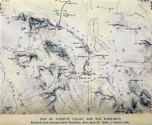
We were en route to the
Rampart Group and had hoped to find a pass through the valley of Simon
Creek over to Tonquin Valley. Because of the amount of spring snow this
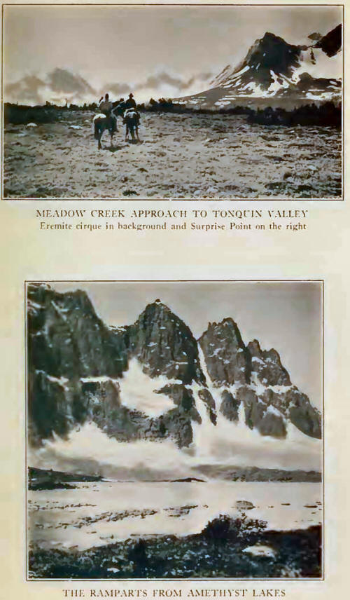
was not possible; but on July 11th, we rode from Jasper, by the Miette
and Meadow Creek trails, to Tonquin Hill. Camp at the southern end of
Amethyst Lakes was reached during the following morning and Surprise
Point was climbed later in the day. On July 13th—eight days after the
start for Mount Hooker—we ascended the Fraser Glacier to the
Erebus-Fraser col; crossed to Simon Glacier, the head of the “North
Whirlpool”; made the first-ascent of Simon Peak (10,899 feet), the high
unclimbed summit of Mount Fraser and the loftiest of the Rampart Group,
and then traversed McDonell Peak (10,776 feet), back to camp. This is no
program for an exhausted climbing party! A week later we were climbing
in the Robson Group. But that is another story.
The ascent of Mount
Hooker was the fulfilment of a great desire. To see and to climb Mount
Brown and Mount Hooker will perhaps not be thought of as a remarkable
alpine ambition. They are probably not the peaks Douglas named; in fact
we remain in ignorance as to precisely where he went, what he did, and
what he named during his few hours at Athabaska Pass. The
Interprovincial Survey has unquestionably done the best thing possible
in perpetuating these classic names by applying them to a lovely peak on
either side of the pass. But the ambition to stand upon them is a deeper
thing than it appears; for the naming of peaks by Douglas, and the
over-estimation of altitude— no matter how strange and ludicrous the
mistake may seem; no matter who was at fault in figuring—these things
first led men in search of great Canadian heights. They came from the
far corners of the earth, following pioneer trails, seeking beauty. And
none there was who returned insensitive to the glory of that mountain
vastness.
So we turned back from
Athabaska Pass, on the Whirlpool trail toward the site of Jasper House,
feeling that we too had come under the spell of this overland route of
the long-ago, and, on Mount Hooker at least, had shared a little in its
adventure.
 |
